How a Newfoundland Fisherman Led Two Norwegians to the Vikings' New World
In the summer of 1960, a Newfoundland fisherman named George Decker walked through wet grass at the northern tip of his island, leading two strangers toward a series of overgrown rectangular mounds near a shallow bay. He had passed these mounds his whole life. The locals called them the old Indian camp, and nobody had ever bothered to dig them up. The two strangers were the Norwegian explorer Helge Ingstad and his wife Anne Stine Ingstad, an archaeologist. They had spent years sailing along the coasts of New England, Nova Scotia, and Labrador asking the same question in every fishing village: do you know any old ruins nobody can explain? Decker took them to the meadow. The Ingstads stopped walking. The shape of the mounds, the orientation toward the bay, the freshwater stream just beyond — every detail matched the layout of Norse farms they had excavated in Iceland and Greenland.
The Ingstads had found what eight centuries of European scholarship had insisted did not exist.
L'Anse aux Meadows is the only verified Viking settlement in the Americas outside Greenland. Its discovery proved that Norse seafarers reached and inhabited North America five hundred years before Christopher Columbus sighted the Bahamas. It also did something stranger and more important. It transformed two medieval Icelandic manuscripts — the Saga of the Greenlanders and the Saga of Erik the Red — from texts dismissed for generations as folklore into reliable historical sources. The mounds in the meadow are the proof that the sagas were never fairy tales. They were a witness statement, and Europe spent eight hundred years refusing to listen.
The story of L'Anse aux Meadows is two stories. One is what happened in the meadow around 1000 CE. The other is what it took to make the world believe it.
Why the Vikings Sailed West: From Iceland to Greenland to the Edge of the Map
The Norse expansion across the North Atlantic was a 250-year leapfrog driven by overpopulation, exile, political collapse in Norway, and the development of the Norse longship — a vessel capable of crossing open ocean in a way no European hull had ever managed before. By the late 9th century, Norse settlers had filled Iceland. By the late 10th, they were running out of farmland there too. The next jump went west.
Erik the Red and the Founding of Greenland's Norse Colonies
Erik Thorvaldsson, known as Erik the Red, was banished from Iceland around 982 CE for committing manslaughter — his second exile in two countries. He sailed west with his family, found the southwestern coast of Greenland, and spent three years exploring the fjords. In 985 CE he returned to Iceland to recruit settlers, calling the new land "Greenland" because, by his own admission, people would be more willing to come if the place sounded inviting. Twenty-five ships left Iceland that summer. Fourteen made it. The Norse settlements at Eystribyggð and Vestribyggð would survive for nearly five hundred years before vanishing entirely in the 15th century, abandoned to the cold and forgotten by the rest of Europe. Greenland was the launching pad. Without it, North America was unreachable; with it, the next island over was a four-day sail across the Davis Strait.
The same cap of ice that hosted Erik's farms would, a thousand years later, host the United States Army's secret nuclear base — Norse turf and Cold War tunnels separated by a millennium and almost nothing else.
Bjarni Herjólfsson and the Storm That Sighted a Continent
The first Norseman to see North America did not mean to. Bjarni Herjólfsson was a merchant sailing from Iceland to Greenland around 986 CE when his ship was driven south by a storm and a fog that lasted days. When the weather cleared, he saw a coastline that did not match any description of Greenland — flat, heavily forested, no glaciers. His crew wanted to land. Bjarni refused. He turned the ship north and continued to his original destination, where he reported what he had seen. He was mocked for not exploring it, sold his ship, and retired.
Fourteen years later, Leif Erikson — Erik the Red's son — bought Bjarni's ship and used Bjarni's directions to find the coast that everyone had laughed at.
Leif Erikson and the Norse Voyages to Vinland Around 1000 CE
The Norse voyages to North America are recorded in two Icelandic manuscripts written down in the 13th century, two hundred years after the events: the Saga of the Greenlanders and the Saga of Erik the Red. The sagas describe four expeditions across roughly fifteen years. They name three lands. They describe encounters with native peoples the Norse called Skraelings — a word whose origin remains contested but which carried clear contempt. For most of the 19th and 20th centuries, mainstream historians treated the sagas as embellished origin stories with little factual basis. The discovery of L'Anse aux Meadows demolished that consensus in a single decade.
The Voyages of Leif, Thorvald, and Thorfinn Karlsefni
Around 1000 CE, Leif Erikson sailed west from Greenland with a crew of 35. He landed first at a region of glaciers and bare stone he named Helluland — the Slab Land. He sailed south and reached a forested, flatter coast he called Markland — the Wood Land. South of Markland he found a place where the rivers held salmon, the grass stayed green into winter, and grapes grew wild. He named it Vinland — the Wine Land — and built houses there. Leif spent one winter and returned to Greenland with timber and grapes.
His brother Thorvald sailed next, around 1003 CE. The expedition went badly. The sagas describe the first recorded violent encounter between Europeans and Indigenous North Americans: Thorvald and his men killed eight Skraelings they found sleeping under boats, an act that triggered a retaliatory attack in which Thorvald was struck by an arrow and died. He was buried somewhere on the North American coast — the first European burial in the Americas, and a grave that has never been found.
Around 1008 CE, the Icelander Thorfinn Karlsefni led the largest expedition: three ships, perhaps 160 settlers, livestock, women, and children. They attempted to establish a permanent colony. They lasted three years. The sagas describe trade with the Skraelings — milk and cloth for furs — followed by escalating violence and an eventual decision to abandon Vinland entirely. Thorfinn's wife Gudrid gave birth during the expedition to a son named Snorri, the first known European child born in the Americas. Gudrid would later return to Iceland, become a nun, and according to the sagas make a pilgrimage on foot to Rome. Her son's descendants are still traceable in Icelandic genealogy.
Helluland, Markland, Vinland: The Three Lands the Norse Named
Modern archaeology and geography map the three saga lands onto specific stretches of the Canadian coast. Helluland is almost certainly Baffin Island — barren, glaciated, exactly as described. Markland is Labrador — densely forested, where the Norse continued to harvest timber for their treeless Greenland colonies for at least three hundred years after the Vinland voyages stopped. Vinland is the harder one. The settlement at L'Anse aux Meadows is at the wrong latitude for grapes; wild grapes grow no further north than the St. Lawrence valley and New Brunswick. This was the central puzzle that delayed acceptance of the Ingstads' discovery for years. The answer turned out to be sitting in the kitchen middens.
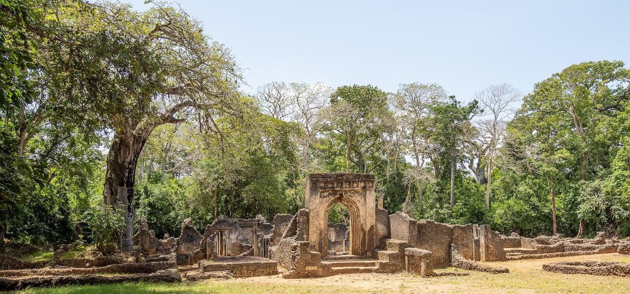
Inside the Norse Outpost at the Tip of Newfoundland
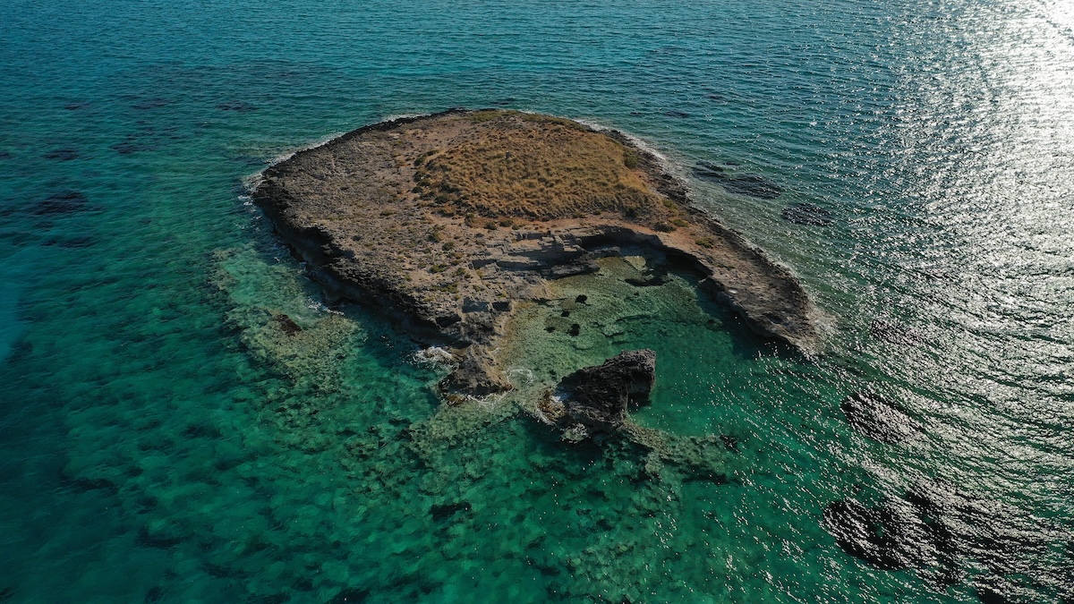
The site at L'Anse aux Meadows occupies a flat coastal terrace overlooking Epaves Bay, sheltered from the open Atlantic by the curve of the Newfoundland coast. The Norse builders chose it for the same reasons they chose every site they ever built: a freshwater stream, a beach for landing boats, and a meadow with peat thick enough to cut into building blocks. Eight structures were laid out across the terrace in a loose cluster. None of them were defensive. There were no palisades, no ditches, no watchtowers. The Norse who built this camp did not expect to be attacked; the lessons of Thorvald's death had either been forgotten or had not yet happened.
The Eight Buildings and the 60-Foot Longhouse
The largest building at L'Anse aux Meadows is a 60-foot turf longhouse with thick walls of stacked sod over a timber frame. Its layout — a central hearth, sleeping benches along the walls, separate cooking and storage areas — matches the skáli form found at Norse farms across Iceland and southwestern Greenland. The structure could have housed perhaps 30 people. Two smaller longhouses, four workshops, and a smithy completed the cluster. Estimated total population at peak occupation: 70 to 90 people. This is not the population of a colony. It is the population of a base camp.
The roofs were gabled, framed in spruce or larch, and covered with peat cut from the bog beyond the terrace. The walls were nearly two meters thick in places. Inside, the buildings would have been warm, smoky, dim, and damp — the smell of wet wool, fish oil lamps, peat smoke, and bodies in close quarters through the long Newfoundland winter.
The First Iron Forge in the Western Hemisphere
A small building set apart from the main cluster contained a stone-lined hearth, slag, and the remains of a clay-walled furnace. This was the smithy. The Norse smelted bog iron — iron oxide nodules that form naturally in peat bogs — using charcoal cut from local trees, and forged the resulting metal into nails, rivets, and boat fittings. The smithy at L'Anse aux Meadows is the earliest documented iron production in the Americas by approximately 500 years. The next time iron would be smelted on the continent would be in 16th-century Spanish Mexico, after the European invasion that everyone remembers.
The 99 iron boat rivets recovered from the site are the most diagnostic Norse artifacts ever found in North America. They are the standard fittings used in clinker-built Viking ships, where overlapping wooden planks are fastened with iron rather than wooden pegs. Indigenous boat-builders did not use iron rivets. Nobody else in 11th-century North America did either. The rivets are the smoking gun.
The Daily Life of Norse Settlers on the Edge of the Known World
For a long time after the Ingstads' first reports, scholars accepted that Vikings had reached Newfoundland but argued the camp had been a brief, all-male reconnaissance party — a few ships of warriors and woodcutters spending one or two seasons before retreating. Three small objects, recovered over several years of excavation, dismantled that reading.
The Bronze Ringed Pin, the Bone Knitting Needle, and the Soapstone Spindle Whorl
A bronze ringed pin was found in the floor of the main longhouse — a Norse cloak fastener of the type produced in Dublin's Hiberno-Norse workshops in the 11th century, identical to examples recovered from sites across Ireland, Scotland, and Iceland. A bone knitting needle came out of one of the workshop floors. The most quietly devastating find was a soapstone spindle whorl — a small disc with a hole in the center, used to weight the spindle when spinning wool into thread. Spinning was women's work in Norse society. So was the knitting. So was much of the textile production that the workshop debris suggests.
The spindle whorl is roughly the size of a poker chip. It is also the artifact that proved Norse women lived at L'Anse aux Meadows. Once you accept that women were present, the entire framing of the site changes. This was not a war party. It was not a one-summer scouting mission. It was a settlement with a domestic component — people preparing wool, sewing, raising whatever children they brought with them — and that means the Norse came here intending to stay long enough that it mattered who could spin thread.
The Butternut Squash That Proved the Vikings Sailed Further South
Among the food remains in the kitchen middens were several butternuts — the hard shells of Juglans cinerea, a tree that does not grow north of New Brunswick. Newfoundland is too cold. The butternuts at L'Anse aux Meadows had to come from somewhere south of the St. Lawrence valley, brought back by Norse ships that had sailed beyond the camp. This finding solved the Vinland latitude problem. L'Anse aux Meadows itself is not Vinland in the saga sense — wild grapes do not grow there. But the camp was a staging point from which Norse expeditions sailed south into territory where grapes did grow, and where butternuts grew, and where the climate matched the saga descriptions exactly. The Norse base was in Newfoundland. Their reach extended at least 800 km further south, into what is now Atlantic Canada and possibly into New England. The sagas had not been exaggerating. The archaeologists had simply been looking in the wrong place.
The Encounter with the Skraelings
The Norse word Skraeling was applied to both the Indigenous peoples the Vikings met in Greenland — the ancestors of the Inuit — and to the peoples they met in North America, who would have included ancestral Beothuk, Innu, and possibly Mi'kmaq groups. The sagas describe both trade and violence. The Norse offered milk products, which the Skraelings had never encountered. They received furs in return. The relationship soured rapidly. The sagas describe a fight at Thorfinn's settlement in which the Norse, despite their iron weapons and superior armor, were nearly overrun by Skraeling warriors using stone tools and surprise. Thorfinn's expedition retreated to its ships. The archaeology at L'Anse aux Meadows has not produced direct evidence of contact — no Skraeling artifacts in the Norse buildings, no Norse goods at nearby Indigenous sites — but the absence is itself information. The Norse left in a hurry.
Why the Norse Abandoned L'Anse aux Meadows After Just a Few Years
The settlement at L'Anse aux Meadows was abandoned in an orderly fashion. The buildings were not burned. There are no graves. No buried hoards, no broken weapons in defensive positions, no skeletal remains in domestic contexts. The Norse packed up what they could carry, walked down to their boats, and sailed away. Nobody ever came back to stay.
Three Years or a Decade? The Debate Over Settlement Length
Older readings of the site, supported by Birgitta Wallace's decades of work for Parks Canada, put the occupation at roughly a decade — a base camp used intermittently across multiple voyages, possibly corresponding to the Karlsefni expedition and one or two others. More recent analysis by the Oxford historian Eleanor Barraclough argues for an even shorter window — perhaps three years — of intensive use, after which the site was emptied and not reoccupied. The new precision of the 1021 CE date supports a brief, concentrated occupation rather than a long, sporadic one. Either way, the timeline is short. By 1030 CE at the latest, the meadow was empty.
Distance, Numbers, and the Limits of Viking Reach
The settlement failed for the same reason every distant outpost in human history fails: the math did not work. Greenland's combined Norse population at its peak was roughly 2,500 people. The settlements were 4,000 km from Iceland and 5,000 km from Norway. They could not afford to lose 90 colonists to Vinland and still hold the homeland. The Indigenous population of North America at the time of contact is estimated at several million. The Norse encountered these populations with a few dozen warriors, no horses, no firearms, and a supply line that ran across the Davis Strait in summer only. The technological gap between Norse iron and Skraeling stone was real but small compared to the demographic gap. The Norse who survived their encounters with the Skraelings concluded what later European explorers would refuse to admit for centuries: the continent was already taken, and they did not have the numbers to take it.
The same calculation would doom the Franklin Expedition eight hundred years later, sailing into the same Canadian latitudes with vastly better technology and the full backing of the British Empire. Iron ships and tinned food did not solve what Norse longships and Norse axes could not solve. The North Atlantic edge of North America has always been a difficult place to keep.
How Helge and Anne Stine Ingstad Found What Academics Said Was a Fairy Tale
Helge Ingstad came to archaeology by accident. He was a Norwegian lawyer turned trapper turned colonial governor turned writer, and by the late 1950s he had become obsessed with the Vinland sagas. Mainstream scholarship in Europe and North America held that the sagas were medieval fiction with possible kernels of memory. Ingstad disagreed. He read the texts as a sailor would read sailing directions and concluded they described a real coastline that could be located. He sold his house, bought a boat, and started looking.
George Decker and the Local Knowledge That Cracked the Case
The Ingstads' approach was direct: sail along the coast, stop in fishing villages, ask the oldest residents whether anyone knew of mounds, ruins, or "old camps" that nobody could explain. In Newfoundland, this method led them to L'Anse aux Meadows in early summer 1960. George Decker, a fisherman in his sixties, told them about the rectangular bumps in the meadow on the edge of the village. He walked them out to the site. The Ingstads recognized the shape immediately. Decker had been looking at a Viking longhouse for his entire life and so had every fisherman in the village before him; the local knowledge that there was something there had survived for generations, but the language to describe what it was had been lost. The professional archaeologists of three continents had missed it. A man who had never published a paper had not.
Anne Stine Ingstad and the Eight-Year Excavation
The actual excavation of L'Anse aux Meadows from 1961 to 1968 was directed by Anne Stine Ingstad, a credentialed archaeologist whose contributions were systematically credited to her husband by the press of the era. She ran the field seasons. She supervised the international team. She wrote the technical reports that established the Norse character of the structures and artifacts beyond academic dispute. Her two-volume scientific publication, completed in 1985, remains the foundational document of the site. Helge promoted the discovery and wrote the popular books. Anne Stine did the science. The site was named the first UNESCO World Heritage Site in 1978, before any of the more famous candidates — before the Pyramids, before the Galapagos, before Machu Picchu. Number one on the list is a meadow in Newfoundland that two people found by asking a fisherman.
The 2021 Solar Storm That Pinned the Norse Date to 1021 CE
For sixty years after the discovery, the dating of L'Anse aux Meadows sat in a 60-year window: somewhere between 990 and 1050 CE, with a mean estimate of 1014. Radiocarbon dating cannot do better than that. In 2021, a team led by Margot Kuitems and Michael Dee at the University of Groningen published a result in Nature that compressed the window to a single calendar year.
How a Solar Storm Became an Archaeological Stopwatch
In 992 CE, a massive solar storm struck Earth. The radiation produced an unmistakable spike in atmospheric carbon-14, and that spike was absorbed by every living tree on the planet that year. The 992 spike shows up as a single bright line in the tree-ring record across continents. The Groningen team examined three pieces of wood from L'Anse aux Meadows that had been cut and worked by Norse axes — the cut marks were preserved in the wood. They counted the rings outward from the 992 spike and found that all three pieces had been felled in the same year: 1021 CE. The Norse were at L'Anse aux Meadows in 1021. They were cutting trees with iron axes. They were living in the longhouses. The date is no longer an estimate. It is a calendar.
This is the precise year the Vikings were in North America. It is also exactly 1,000 years before the date became known.
Visiting L'Anse aux Meadows: The First UNESCO World Heritage Site
L'Anse aux Meadows National Historic Site is operated by Parks Canada and lies at the northern tip of the Great Northern Peninsula of Newfoundland, accessible by Route 436 from St. Anthony, the nearest town. The site is open from June through early October. Outside that window, the road is open but the visitor center is closed and the site is buried in snow.
The Reconstructed Longhouses and the Original Mounds
The site contains two distinct elements. The original Norse foundations — the eight building outlines, the midden, the smithy hearth — are preserved as low grass-covered ridges on the coastal terrace, marked with interpretive signs and walking paths. A short distance away, Parks Canada has built full-scale reconstructions of three of the buildings, including the main longhouse, framed in spruce and roofed with peat exactly as the Norse would have done. Costumed reenactors work the smithy and the loom during summer hours. The reconstructions are educational; the original mounds are the real thing. Visitors are asked to stay on the marked paths to protect the surviving turf foundations, which are fragile and continue to be subject to ongoing low-level archaeological monitoring.
The visitor center holds the artifacts that proved the case: the bronze ringed pin, the bone knitting needle, the soapstone spindle whorl, samples of the iron rivets and slag. The objects are small and unimpressive at a glance. Their meaning is not.
Standing at the Edge of Two Worlds
The meadow at L'Anse aux Meadows is, in one specific sense, the most important place in the Western Hemisphere. The descendants of humans who left Africa tens of thousands of years ago and walked west across Eurasia met, in this meadow, the descendants of the same humans who had walked east through Asia and across the Bering land bridge into the Americas. The two migration streams that had circled the planet in opposite directions converged here, briefly, around 1021 CE. They traded furs and milk. They killed each other. They went home. The encounter was a footnote in their own time and a forgotten one for nearly a millennium.
Standing on the path above the original mounds, looking out across Epaves Bay toward Labrador, the site does not announce itself. There is no monument, no city, no scale. Just a meadow, a stream, and a curve of stone foundations under the grass. The Vikings who built this place sailed away and never wrote down where it was. The fishermen who lived next to it for four centuries called it the old Indian camp because they had no other name for it. The official version of history begins in 1492, when a Genoese sailor working for the Spanish crown landed on a Bahamian island and announced that Europe had discovered a new world. The Norse had been here for almost five hundred years. The meadow remembers what the textbooks forgot.
Frequently Asked Questions
Where is L'Anse aux Meadows located?
L'Anse aux Meadows sits at the northern tip of the Great Northern Peninsula of the island of Newfoundland, in the Canadian province of Newfoundland and Labrador. The site overlooks Epaves Bay, facing the Strait of Belle Isle and the Labrador coast across the water. The nearest town is St. Anthony, roughly 50 km to the southeast, accessible via Route 436. The site is operated by Parks Canada and is open to visitors from June through early October.
Who discovered the Viking settlement at L'Anse aux Meadows?
The Norwegian explorer Helge Ingstad and his wife, the archaeologist Anne Stine Ingstad, identified the site in 1960 after a local fisherman named George Decker showed them a series of overgrown rectangular mounds that residents had called "the old Indian camp" for generations. Anne Stine directed the formal excavations from 1961 to 1968, working with an international team of archaeologists. Her two-volume scientific publication completed in 1985 remains the foundational technical document of the site.
How old is L'Anse aux Meadows and when were the Vikings there?
The Norse occupation dates to approximately 1000 CE, with carbon dating placing it in a window between 990 and 1050 CE. In 2021, researchers at the University of Groningen used a tree-ring spike caused by a massive solar storm in 992 CE to pinpoint the exact year of Norse logging activity at the site to 1021 CE. The Vikings were physically present at L'Anse aux Meadows that year, cutting timber with iron axes and living in the longhouses.
Is L'Anse aux Meadows the same as Vinland?
L'Anse aux Meadows is not Vinland in the strict saga sense. The Vinland Sagas describe a region where wild grapes grew, and grapes do not grow in Newfoundland. Archaeologists found butternut shells at the site, which only grow south of the St. Lawrence valley, indicating that L'Anse aux Meadows was a base camp from which Norse expeditions sailed further south into territory that does match the saga descriptions of Vinland. The settlement was the launching point; Vinland itself was somewhere in modern Atlantic Canada or New England.
How many Vikings lived at L'Anse aux Meadows?
The eight buildings excavated at the site could have housed approximately 70 to 90 people at peak occupation. The settlement was not a permanent colony but a base camp for further exploration, used for boat repair, iron forging, and preparation for southward voyages. The presence of a soapstone spindle whorl and other textile-related artifacts indicates that women lived at the site alongside men, suggesting the Norse intended to stay long enough that domestic activities mattered.
Why did the Vikings abandon L'Anse aux Meadows?
The settlement was abandoned in an orderly fashion within roughly three to ten years of its founding, with no evidence of violent destruction. The reasons combine demographics, distance, and Indigenous resistance. The Norse colonies in Greenland that supplied the expedition had a total population of only about 2,500 people, located 4,000 km away across the Davis Strait. Conflict with the Indigenous peoples the Norse called Skraelings made the settlement difficult to defend. The Norse concluded that the continent was already inhabited by populations they could not displace, and they sailed home.
Why is L'Anse aux Meadows historically significant?
The site is the only confirmed pre-Columbian European settlement in the Americas outside Greenland, proving that Norse seafarers reached and inhabited North America roughly 500 years before Christopher Columbus's 1492 voyage. The discovery transformed the Vinland Sagas from texts dismissed as medieval folklore into reliable historical sources. L'Anse aux Meadows also contains the earliest documented iron production in the Western Hemisphere, predating Spanish colonial smelting in Mexico by approximately 500 years. The site was inscribed as the first UNESCO World Heritage Site in 1978.
Sources
* [Evidence for European presence in the Americas in AD 1021] - Margot Kuitems, Birgitta L. Wallace, Charles Lindsay, et al., Nature (2021)
* [The Norse Discovery of America] - Helge Ingstad and Anne Stine Ingstad, Norwegian University Press (1985)
* [Westward to Vinland: The Discovery of Pre-Columbian Norse House-Sites in North America] - Helge Ingstad, Harper & Row (1969)
* [The Norse Discovery of America: A Critical Analysis of the Norse Sagas Relating to the Voyages of the Vikings to North America] - Birgitta Wallace, Newfoundland Studies (2003)
* [L'Anse aux Meadows National Historic Site of Canada] - Parks Canada Agency (2024)
* [L'Anse aux Meadows National Historic Site - World Heritage List] - UNESCO World Heritage Centre (1978)
* [The Vikings: A History] - Robert Ferguson, Penguin (2009)
* [The Vinland Sagas: The Norse Discovery of America] - translated by Magnus Magnusson and Hermann Pálsson, Penguin Classics (1965)
* [Beyond the Northlands: Viking Voyages and the Old Norse Sagas] - Eleanor Rosamund Barraclough, Oxford University Press (2016)
* [Archaeological Investigations at L'Anse aux Meadows] - Bengt Schönbäck and Birgitta Wallace, Parks Canada Research Bulletin (1976)
* [A Burst of New Evidence for Viking Travels] - NASA Earth Observatory (2022)