A City Floating in the Mist
The first thing that hits you is not the view, but the air. At 2,430 meters above sea level, the air in the saddle between the peaks of Machu Picchu and Huayna Picchu is thin, crisp, and carries the distinct, wet scent of the high Amazonian cloud forest. It is a scent of moss, wet granite, and orchids, a sensory reminder that you are standing on a ecological frontier where the high Andes plummet dramatically into the Amazon basin.
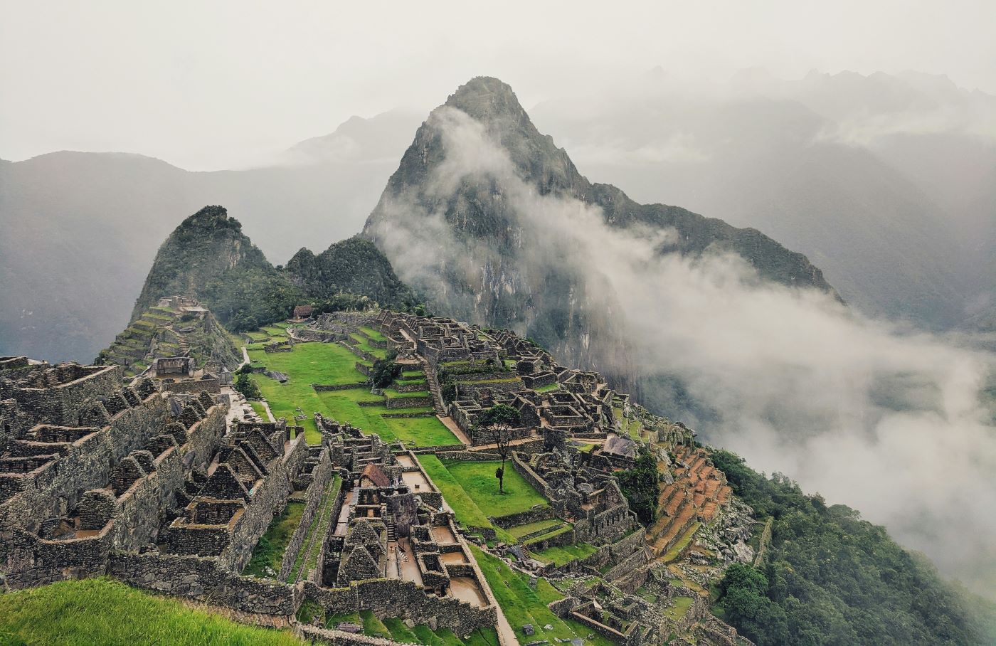
When the morning mist parts—a phenomenon that happens with slow, deliberate theatricality—the grey-white curtain lifts to reveal a scene that defies logical explanation. A complex of grey granite palaces, temples, and storehouses clings to a narrow ridge, surrounded on three sides by the violent, churning waters of the Urubamba River, some 450 meters below. It is a city that feels as though it was not built on the mountain, but rather emerged from it.
For the modern visitor, the initial reaction is often a paralyzed silence. Photographs, no matter how high-definition, fail to capture the verticality of the site. The drop-offs are terrified and immediate. The surrounding peaks—the Apus—loom with a dark, verdant heaviness that makes the stone city feel small, vulnerable, and yet defiantly permanent.
To understand Machu Picchu, one must strip away the modern veneer of tourism—the buses winding up the Hiram Bingham Highway, the crowds at the Watchman’s Hut, the selfie sticks. One must look at this place through the eyes of the people who built it. This was not a fortress designed for war, nor was it a bustling commercial hub. It was a sanctuary in the clouds, a private estate for the divine ruler of the largest empire in the pre-Columbian Americas. It was a statement of power, piety, and an obsessive desire to bind the earth to the sky.
This article explores the human reality of Machu Picchu—not just the mechanics of its construction, but the soul of its purpose. It is an investigation into the life, the worship, and the sudden, silent abandonment of the Incan masterpiece.
The World of the Inca: The Empire of the Four Quarters
To grasp the magnitude of this citadel, one must first understand the civilization that willed it into existence. By the mid-15th century, the Inca Empire—known to its people as Tahuantinsuyo, or "The Four Regions Together"—was the largest and most sophisticated state in the Western Hemisphere. It stretched along the spine of the Andes from modern-day Colombia to Chile, encompassing deserts, rainforests, and snow-capped peaks.
It was an empire built without the wheel, without iron tools, and without a written script. Instead, it was held together by a complex system of labor tax (mit'a), a vast network of roads (Qhapaq Ñan), and a rigid social hierarchy topped by the Sapa Inca, the Son of the Sun.
The Vision of Pachacuti
Machu Picchu is widely believed by archaeologists and historians to have been built as a royal estate for the Sapa Inca Pachacuti (1438–1471). Pachacuti was the Alexander the Great of the Andes, the transformer of the world who expanded the Inca kingdom from a small Cusco valley chiefdom into a sprawling empire.
This site was his personal retreat. It was built around 1450, at the height of imperial power. Unlike Cusco, which was the administrative and political capital, Machu Picchu was a place of leisure, diplomacy, and intense religious communion. It was a warm-weather getaway, lower in altitude than the frigid capital of Cusco, allowing the royal family to enjoy the lush, oxygen-rich air of the cloud forest.
The Chosen People
Because it was a royal estate, the population of Machu Picchu was highly selective. It was never a large city; at its peak, perhaps only 750 to 1,000 people lived here, and many of those were seasonal staff who arrived when the Emperor was in residence.
The permanent residents were the elite caretakers: priests, astronomers, artisans, and the Yanaconas (retainers to the nobility). There was also a significant presence of Aqllas, the "Chosen Women" or Virgins of the Sun, who were selected from across the empire for their beauty and skill in weaving and brewing chicha. Skeletal remains found at the site show a diverse population drawn from the coast, the highlands, and the deep jungle, proving that Machu Picchu was a cosmopolitan microcosm of the empire itself. These were not peasants struggling to survive; they were the privileged support staff of a living god.
Sacred Geography: Listening to the Mountains
For the Inca, the landscape was not inanimate matter to be conquered; it was alive. The earth (Pachamama) and the mountains (Apus) were deities that required respect, payment, and constant dialogue. Machu Picchu’s location was not chosen for its defensibility, but for its sacred geography.
The Apus (Mountain Spirits)
The citadel sits in the center of a dramatic natural amphitheater. It is surrounded by holy peaks: Huayna Picchu to the north, Machu Picchu mountain to the south, the massive Salcantay to the west, and Veronica to the east. In Incan cosmology, these peaks are the protectors of the region.
The placement of the city is deliberate. Key structures within the complex align perfectly with these mountains. The "Sacred Rock" at the north end of the city creates a visual mimicry of the mountain Pumasillo in the distance. The Intihuatana stone aligns with the peak of Huayna Picchu. The entire city is designed to function as a geometric bridge between the mountains and the stars. It is a place where the barrier between the human world and the spirit world was considered thin.
The Intihuatana: The Hitching Post of the Sun
At the highest point of the Urban Sector stands the Intihuatana, a beautifully carved, multi-faceted stone pillar. While popular lore calls it a "sundial," its function was far more profound. It was a ritual tool used to "tie up" the sun during the winter solstice, ensuring that the celestial orb would not drift too far away from the earth, which would bring eternal cold and famine.
The stone is carved from the living bedrock of the mountain. It is not a separate sculpture placed there; it is the mountain itself, shaped by human hands. During the solstice, the priests would observe the shadows cast by the pillar to determine the precise moment for planting and harvesting. It was a scientific instrument wrapped in religious awe, a testament to the Inca’s advanced understanding of astronomy.
The Temple of the Sun
Below the Intihuatana lies the Temple of the Sun, the only round building in the entire complex. It features the finest stonework in the city, with blocks polished to a glass-like smoothness. The tower is built around a large natural rock, which served as an altar.
The temple’s east-facing window is perfectly aligned to capture the first rays of the rising sun on the June solstice. When the light hits the rock altar, it illuminates a specific groove, signaling the beginning of the most sacred time of the year. This interaction between light and stone was the heartbeat of the city’s spiritual life.
Life in the Clouds: The Human Experience
If we strip away the silence of the ruins, what did life actually sound and smell like here in 1460?
A Day in the Life
Imagine the smell of woodsmoke drifting from the thatched roofs of the residential compounds. The air would be filled with the scent of roasting corn and guinea pig (cuy), and the sharp, fermented tang of chicha, the corn beer that fueled both labor and ritual.
The soundscape would be dominated by the rush of the wind through the pass and the constant, soothing burble of water. The Incas were hydraulic masters, and a complex system of 16 fountains cascaded through the city, providing fresh spring water to every sector. The fountains were designed to create a specific acoustic quality—a "white noise" that masked conversations and enhanced the sense of tranquility.
The people here were beautifully dressed. The Incas valued textiles more than gold. The Vicuña and Alpaca wool garments worn by the nobility were intricately woven with geometric patterns (tokapu) that told stories of lineage and status. The flash of brilliant reds (dyed from cochineal beetles) and deep blues would have stood out starkly against the grey stone and green terraces.
Farming the Vertical
The famous green steps—the agricultural terraces—were the engine of the city. But they were also an engineering marvel. They created a micro-climate; the stone retaining walls absorbed the sun’s heat during the day and radiated it back into the soil at night, preventing frost and allowing the Incas to grow crops that normally wouldn’t survive at this altitude.
Farmers worked these narrow strips of land, growing maize, potatoes, and coca leaves. The soil in the terraces was not native to the mountain; it was rich topsoil hauled up from the valley floor, layered over gravel and sand to ensure perfect drainage. This was high-tech farming, designed to sustain the elite population in luxury.
Hierarchy and Order
The city layout reflects the rigid Incan sense of order. A large central plaza divides the site into two distinct sectors: the Agricultural Sector (terraces and storehouses) and the Urban Sector (temples and residences).
Within the Urban Sector, there is a further division. The "Wise Persons" district, where the priests and nobility lived, features complex masonry and private courtyards. The "Three Doorways" district represents a more modest, yet still comfortable, living area for the artisans and retainers. Even the layout of the city reinforced the idea that while everyone had a role in the empire, not everyone was equal.
The Aesthetics of Survival: Architecture in Harmony
The beauty of Machu Picchu lies in its humility. In Western architecture, castles often seek to dominate the landscape, to impose geometry upon nature. Incan architecture seeks to blend with it.
Stone as Art
The famous "Ashlar" masonry—where stones are cut to fit together without mortar so tightly that a knife blade cannot pass between them—is not just about structural integrity. It is an aesthetic choice. The stones are often "pillowed," with slightly convex faces that catch the light and create a soft, organic texture.
Look closely at the walls. You will see that the Incas often incorporated existing bedrock into their walls, rather than blasting it away. A house might have a floor made of natural granite, or a wall that merges seamlessly into a cliff face. This technique, known as "organic integration," creates the illusion that the city grew out of the rock naturally, like a crystal formation.
The Water Channels
Water was sacred, and its movement through the city was choreographed. The main canal brought water from a natural spring on the slopes of Machu Picchu mountain, traveling 749 meters before entering the city.
The first fountain was reserved for the Emperor’s compound, ensuring the Sapa Inca received the purest water. From there, it cascaded down through the 16 distinct fountains, accessible to the priests and the populace. The sight and sound of this water, sparkling in the high-altitude sun and echoing off the stone walls, was a central element of the city’s beauty. It was a reminder that the Incas had tamed the elements not by force, but by clever redirection.
The Silence: Abandonment and Rediscovery
For all its grandeur, Machu Picchu was a short-lived dream. The city was inhabited for less than 100 years. By roughly 1535, it was ghost town.
The Sudden End
Why did they leave? There is no evidence of a battle at Machu Picchu. The stones are not scorched; the walls were not breached. The abandonment was likely quiet and tragic.
As the Spanish Conquistadors ravaged the Inca capital of Cusco in the 1530s, the social order of the empire collapsed. The supply lines that fed Machu Picchu—bringing food, textiles, and news from the capital—would have been severed. Even worse, smallpox likely reached the royal estate before the Spanish soldiers did. The disease decimated the population, killing the laborers and the nobility alike.
The remaining residents likely made the decision to flee, perhaps retreating further into the jungle to the neo-Incan stronghold of Vilcabamba. In a final act of protection, they may have burned the forest trails leading to the citadel, effectively erasing the path and hiding the site from the Spanish invaders. It worked. The Spanish never found Machu Picchu. It slept in the clouds, reclaimed by the jungle, for nearly four centuries.
The Local Secret vs. The "Lost City"
When Hiram Bingham III, the Yale historian, arrived in 1911, he was looking for Vilcabamba, the last refuge of the Incas. He didn't "discover" Machu Picchu in the sense that no one knew it was there.
When he climbed the ridge on that cold July morning, guided by a local innkeeper named Melchor Arteaga, he found indigenous families living among the ruins. The Richarte and Alvarez families were farming the ancient terraces, using the same water channels the Incas had built 400 years earlier. They called the place "Old Peak" (Machu Picchu).
However, to the outside world—to history, science, and the global public—it was indeed lost. Bingham’s genius was not in finding the site, but in recognizing its significance and clearing the vegetation to reveal the architectural masterpiece beneath. His photographs in National Geographic brought the "Lost City" to the world, igniting a fascination that has never waned.
The Modern Pilgrimage: Visiting Today
Today, Machu Picchu is the most visited archaeological site in South America. The silence that Bingham found is gone, replaced by the shuffle of thousands of feet. Yet, the magic remains resilient.
Respecting the Site
Visiting Machu Picchu today requires planning and a shift in mindset. It is no longer a place you can simply wander into. The Peruvian Ministry of Culture has implemented strict circuits to manage the flow of people and protect the soft granite from erosion.
The modern pilgrim must choose their path carefully. Do you take the train from Ollantaytambo, winding along the Urubamba River in comfort? Or do you walk the Inca Trail, a grueling four-day trek that approaches the city through the Sun Gate (Intipunku), replicating the arrival of the ancient elite?
The Experience
The best time to visit is during the shoulder seasons (April-May or September-October), where the likelihood of rain is lower, but the summer crowds have not yet peaked.
Visitors must be prepared for the physical reality of the site. The altitude is significant, the stairs are steep and uneven, and the sun is intense. But the physical exertion is part of the price of admission. As you climb the terraces or hike to the top of Huayna Picchu, you feel the same burn in your lungs that the chasquis (messengers) felt five centuries ago.
There is an ethical weight to being here. Every footstep wears down the stone. Every plastic bottle left behind is a scar. To visit Machu Picchu is a privilege, and it demands a reverence for both the history and the fragility of the structure.
Conclusion: The Echo of an Empire
Machu Picchu stands as a defiant paradox. It is a city built of massive stone that feels as light as a cloud. It is a site of immense human effort that was surrendered back to nature without a fight.
It is the ultimate testament to the Incan worldview—a civilization that did not see itself as separate from the earth, but as a partner to it. They cut the stone to honor the mountain, diverted the water to honor the river, and built their windows to frame the sun.
When you stand at the Guardhouse looking out over the silent, grey ruins, you are not just looking at a postcard. You are looking at a frozen moment in time—a snapshot of a civilization at its absolute zenith, suspended in the mist, waiting for its people to return. They never did, but in the enduring perfection of their walls, they never really left.
Frequently Asked Questions
What is the best time of year to visit Machu Picchu to avoid rain?
The most stable weather occurs during the dry season, from May to September. June and July are the driest months but also the busiest with peak tourist crowds. To balance clear skies with manageable crowds, aim for the "shoulder months" of April or October. Note that the rainy season (December to March) can obscure views, and the Inca Trail is closed for maintenance every February.
How difficult is the hike to Huayna Picchu?
The hike to Huayna Picchu (the tall peak behind the ruins) is strenuous and steep. It requires a specific ticket purchased months in advance. The trail takes about 45–60 minutes to ascend and includes narrow, exposed stairs known as the "Stairs of Death." It is not recommended for those with severe vertigo or low fitness levels. The alternative, Machu Picchu Mountain, is a longer (2-3 hours) but less vertical hike.
Can I buy entrance tickets at the gate?
No. Tickets are not sold at the entrance of the citadel. You must purchase them online in advance through the official Ministry of Culture website or an authorized agency. Tickets are limited by daily capacity and specific time slots. During high season, tickets can sell out 2–3 months in advance. You must enter during your assigned hour, or you will be denied entry.
How does the altitude at Machu Picchu compare to Cusco?
Surprisingly, Machu Picchu is lower than Cusco. Cusco sits at 3,399 meters (11,152 ft), while Machu Picchu is at 2,430 meters (7,972 ft). Most visitors acclaimatize in Cusco for two days before heading down to the Sacred Valley and Machu Picchu. While altitude sickness is less common at the ruins than in Cusco, the physical exertion of climbing the terraces can still cause shortness of breath.
Are there restrooms inside the citadel?
No. There are no toilets inside the archaeological complex. The only facilities are located outside the main entrance gate. Once you scan your ticket and enter the turnstiles, you cannot leave to use the restroom and re-enter (unless you have a specific ticket type that allows re-entry, which is rare under new regulations). Plan accordingly before starting your circuit.
Sources & References
- UNESCO World Heritage Centre – "Historic Sanctuary of Machu Picchu."
- Bingham, Hiram – Lost City of the Incas: The Story of Machu Picchu and Its Builders. (Weidenfeld & Nicolson, 1948).
- Wright, Kenneth R. & Valencia Zegarra, Alfredo – Machu Picchu: A Civil Engineering Marvel. (ASCE Press, 2000).
- Hemming, John – The Conquest of the Incas. (Mariner Books).
- D'Altroy, Terence N. – The Incas. (Blackwell Publishing).
- Reinhard, Johan – Machu Picchu: The Sacred Center. (Lima: The Machu Picchu Historical Sanctuary).
- Burger, Richard L. – "The Life and Death of the 'Lost City'." (Archaeology Magazine).
- Ministry of Culture (Peru) – "Machu Picchu Visiting Regulations and Circuit Maps." (Official Government Protocol).
- Turner, Bethany L. – "Variation in residential history at Machu Picchu." (Journal of Archaeological Science).