The 9/11 Activation: How Mount Weather Served as the Shadow Government
The heavy steel blast doors of Mount Weather do not move for drills. On the morning of September 11, 2001, they groaned open with a purpose that had not been felt since the height of the Cuban Missile Crisis. As the second tower of the World Trade Center collapsed into a plume of pulverized concrete, the Alpha Team—a handpicked cadre of high-ranking federal officials—was already being whisked away from the capital in blacked-out Suburbans and Sea Stallion helicopters. They were not heading for a safe house; they were heading for a tomb that was designed to act as a womb for a new, scorched-earth version of the United States.
The Alpha Team and the September 11 Evacuation Protocols
The air inside the mountain on that Tuesday morning was filtered, chilled, and tasted of nothing. While the rest of the world watched the television in a state of paralyzed horror, the staff at the Mount Weather Emergency Operations Center moved with clinical precision. This is a facility that views a national tragedy not as a shock, but as a trigger for a sequence of pre-ordained maneuvers. The arrival of the Shadow Government changed the internal pressure of the facility. Suddenly, the underground city, which usually hums with the maintenance of servers and empty corridors, was populated by the men and women who would rule over the ashes. They walked through the massive 10-foot-thick reinforced concrete doors, knowing that if those doors stayed shut, the world they knew was likely gone forever.
The physical transition was immediate. Security details in civilian clothes were replaced by tactical teams in full gear. The silence of the mountain was broken by the frantic tapping of keyboards and the low murmur of officials trying to contact family members they had just essentially abandoned. Inside the mountain, there is no weather, no sun, and on that day, no hope for a return to normalcy. The facility began to breathe as a living entity, its lungs being the massive ventilation fans that scrub the air of outside contaminants, ensuring that even if the atmosphere above became a toxic slurry of debris and fallout, the bureaucracy would remain oxygenated.
Continuity of Government (COG) and the Transfer of Executive Power
Continuity of Government protocols are the ultimate insurance policy for an empire. On 9/11, these protocols were not just activated; they were lived. The atmosphere shifted from a sleepy federal outpost to the literal capital of the free world in under sixty minutes. While the President was airborne on Air Force One, Mount Weather became the terrestrial anchor for American sovereignty. The Alpha Team began the process of establishing a parallel bureaucracy. They did not need to ask for permission; the authority was baked into the mountain’s foundations. This was the moment the High Point project was built for—a moment of absolute uncertainty where the only thing that remained certain was the survival of the administrative state.
Records indicate that the mobilization involved shifting the executive authority to a classified list of successors. These individuals were placed in secure rooms equipped with communications gear that bypassed the standard civilian grid. The focus was not on rescue or recovery—that was for the agencies on the surface. The focus inside Mount Weather was on the maintenance of the legal chain of command. If the nuclear suitcase had been opened that day, the orders would have been validated by the ghosts sitting in the hollowed-out granite of Virginia. The psychological toll of this mobilization cannot be overstated; these officials were operating under the assumption that they were the last vestiges of a dying civilization.
Construction and History: From Weather Station to Nuclear Shelter
The Blue Ridge Mountains were once the site of harmless atmospheric study. Before it was a fortress, the peak known as Mount Weather was an outpost for the U.S. Weather Bureau. In the late 1800s, scientists launched kites to measure the winds, unaware that the very ground beneath them would one day be hollowed out to withstand the force of a thousand suns. The transition from a site of science to a site of survival began in earnest when the Cold War turned the American skyline into a target.
The High Point Project: Cold War Engineering in the Blue Ridge Mountains
President Dwight D. Eisenhower understood that the nuclear age required a new kind of architecture. In 1954, the Bureau of Mines began a massive excavation project under the code name High Point. They did not just dig a hole; they carved out a city. The greenstone and granite of the mountain were blasted away using thousands of pounds of dynamite, creating a space that could house up to 2,000 people for months at a time. The project was shrouded in a level of secrecy that rivaled the Manhattan Project. Local residents in the town of Bluemont, Virginia, watched as hundreds of trucks hauled away debris, yet the federal government remained tight-lipped about what was being installed in the mountain’s belly.
This excavation was only one half of a continental defensive posture; if Mount Weather serves as the administrative brain of the shadow government, its defensive fist remains buried thousands of miles west under 2,000 feet of granite at Cheyenne Mountain, the hardened nerve center designed to track incoming strikes.
The engineering required to stabilize the mountain was immense. Workers installed thousands of roof bolts, some reaching twenty feet into the rock, to prevent the ceiling from collapsing under the shockwaves of a near-miss nuclear strike. The excavation created a series of interconnected tunnels and chambers, some large enough to house three-story buildings. This was the birth of the Deep Underground Command Center concept.
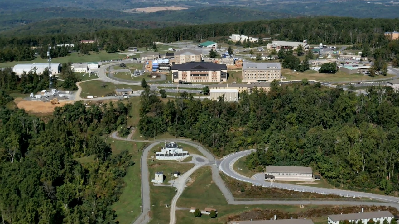
Inside Area B: The 600,000 Square Foot Underground City Layout
The interior of Mount Weather is a masterclass in psychological and structural engineering. It is divided into Area A, the surface, and Area B, the underground. Area B is a 600,000-square-foot labyrinth that functions as a self-contained ecosystem. It features its own internal streets, a private hospital, a crematorium, and a sewage treatment plant. The facility is powered by a massive array of diesel generators and cooled by a lake of chilled water held in a subterranean cavern. To prevent the psychological collapse of the residents, the streets were given names like Atlantic Avenue and Washington Boulevard, and the lighting was programmed to mimic the rising and setting of a sun they might never see again.
The hospital is equipped for major surgery, and the cafeteria is stocked with enough freeze-dried and canned rations to feed an army for a year. But the most striking feature is the office space. Rows upon rows of desks, filing cabinets, and lead-lined safes wait for the arrival of bureaucrats who will never come unless the world is ending. There is a specific smell to Area B—a mix of ozone, old paper, and the sterile scent of industrial cleaning agents. It is a place where time stands still. The clocks are all synchronized to a master atomic clock, ensuring that even if the outside world loses its sense of time, the mountain keeps the beat of the empire.
The 1974 TWA Flight 514 Crash and the Exposure of the Secret Site
Secrecy in a democracy has an expiration date, often dictated by tragedy. For twenty years, Mount Weather existed as a ghost in the machine—rumored but unconfirmed. That changed on a foggy morning in December 1974, when the mountain claimed the lives of nearly a hundred civilians and, in doing so, surrendered its own anonymity.
Why the Flight 514 Tragedy Forced Government Disclosure
TWA Flight 514 was en route from Columbus to Dulles International Airport when the pilots, misled by confusing air traffic control instructions regarding an approach in bad weather, descended too early into the Virginia mist. The Boeing 727 slammed into the ridge of Mount Weather at five hundred miles per hour. All 92 people on board were killed instantly. The wreckage was scattered across the very ridge that housed the most sensitive communications arrays of the American government. When the first responders and the press arrived at the scene, they found more than just a plane crash. They found a barbed-wire perimeter guarded by soldiers with orders to shoot, standing in front of a facility that was not on any map.
The debris from the crash was inextricably linked with the facility's hidden infrastructure. Wreckage was found tangled in the high-gain antennas used for classified communications. As recovery teams worked to identify the remains of the passengers, they were under constant surveillance by federal agents who were less concerned with the dead and more concerned with the security of the mountain. The irony was bitter: a civilian tragedy had punched a hole through the veil of national security. Families of the victims, looking for answers about why their loved ones died, stumbled upon the most guarded secret of the Cold War.
Investigative Journalism and the Declassification of Federal Bunkers
The crash of Flight 514 acted as a pry bar for investigative journalists. The Washington Post and other outlets began asking why a plane crash in the woods was being treated like a breach of national security. The subsequent investigation forced the government to acknowledge the existence of the special facility. While the Pentagon attempted to downplay its significance, labeling it a civil defense site, the cat was out of the bag. The public learned that while they were being told to duck and cover under school desks, their leaders had built a billion-dollar palace of survival.
The disclosure led to a series of congressional inquiries. Lawmakers who had been kept in the dark about the facility's true purpose demanded to know how much tax money was being spent on a bunker they were not invited to. The government’s response was a masterclass in obfuscation, admitting to the site’s existence while refusing to provide details on its capacity or the specific criteria for entry. This era marked a shift in the American psyche—a realization that there was a Breakglass in Case of Emergency government waiting in the wings, and it did not include the taxpayers who funded it.
The Sociology of Survival: Who is Eligible for the FEMA Bunker?
The math of survival is cold, and it does not care about your family. Mount Weather is the ultimate physical manifestation of a hierarchy of human value. It is the Ark, but the invitation list is restricted to the architects of the world's destruction. The most painful reality of the facility is not the threat of nuclear war; it is the quiet, bureaucratic decision of who is essential and who is collateral damage.
The selection process is a cold separation of powers. While Mount Weather was engineered to preserve the executive branch, Raven Rock was carved out as a granite fortress for the military command of the Joint Chiefs, and the legislative branch was assigned its own tomb beneath the manicured lawns of The Greenbrier. This ensured that the three pillars of the state were buried in separate, strategically distant graves.
Essential Personnel Lists and the Hierarchy of Government Survival
The Continuity of Government list is a living document. It is a ranking of human utility. If the sirens wail, a Cabinet Secretary is whisked to the mountain, but their spouse and children are left behind to face the fallout. This is the reality of Mount Weather: the realization that the people tasked with saving the country are required, by law, to abandon their own humanity. There are enough cots for the politicians, the generals, and the technical staff to keep the lights on, but there is no room for the public.
Inside the mountain, the social structure is rigid. Rank does not disappear underground; it is amplified. The quality of your quarters and your proximity to the command center are dictated by your GS-level or military grade. There are specific protocols for how to handle the psychological breakdown of staff who realize their families are likely dead on the surface.
These protocols are not based on empathy; they are based on the maintenance of operational capacity. Sedation and isolation are the primary tools for managing grief in the bunker. It is a sterile, sociopathic environment where the only metric of success is the continued transmission of a radio signal.
Psychological Effects of Long-Term Isolation in Underground Facilities
Living inside Mount Weather is an exercise in clinical isolation. The air is recycled until it feels thin; the silence is heavy, broken only by the hum of the ventilation system. Psychological studies conducted on similar bunkers suggest a rapid onset of bunker mentality—a state of hyper-paranoia and detachment from the surface world. In a true doomsday scenario, the occupants of Mount Weather would be presiding over a graveyard via satellite feed. The sensory reality is one of grey walls, fluorescent lights, and the knowledge that the only thing between you and the end of history is a few hundred feet of rock.
The food is designed for shelf-life, not flavor. The water is treated until it tastes of chemicals. There are no windows, no pets, and no plants that are not plastic. The human brain, deprived of the natural rhythms of the earth, begins to fray. Staff rotations are kept short during peacetime to prevent mountain fever, but in a crisis, those rotations would cease.
The people inside would become the last prisoners of the old world, trapped in a high-tech dungeon while they wait for the radiation levels outside to drop to a level that might allow them to step out into a world they no longer recognize.
FEMA Operations Today: National Cyber Security and Emergency Alerts
Mount Weather did not die with the Cold War. In fact, its mission has expanded. Today, it is officially the Mount Weather Emergency Operations Center, managed by FEMA. It has transitioned from a nuclear hideout into a central hub for the digital and biological threats of the 21st century.
Mount Weather’s Role in Modern Pandemic and Cyber Warfare Response
The threats of the 1950s have been replaced by the invisible terrors of the modern era. Mount Weather now serves as a primary command node for national cyber-defense. In the event of a catastrophic grid failure or a crippling state-sponsored hack, the servers inside the mountain are designed to keep the American financial and administrative systems on life support. During the COVID-19 pandemic, the facility's role in coordinating national logistics once again proved that the mountain is never truly dormant.
The infrastructure has been upgraded to include massive server farms that mirror the data of every major federal agency. This is Data Continuity. If Washington were to be hit by a logic bomb that erased the Treasury's records or the Social Security Administration's database, the mountain holds the backup. The mission has shifted from physical survival to digital resurrection. The staff now includes as many IT specialists and data analysts as it does security personnel. They are the guardians of the American ghost—the digital footprint of a nation that could be wiped out in a nanosecond.
The FEMA National Radio System and the Emergency Alert System Hub
If you have ever heard the jarring tone of the Emergency Alert System on your phone or television, you have felt the reach of Mount Weather. The facility is a primary node for the FEMA National Radio System. It has the capability to override almost all domestic broadcasts, providing a National Level voice for the President. This digital fortress does not operate in a vacuum; it is the western anchor of a global surveillance web that links directly with the Pine Gap facility in the Australian outback—a joint-defense site that acts as the mountain’s eyes in the Eastern Hemisphere, ensuring the American shadow government maintains global situational awareness even from beneath a ridge in Virginia.
The EAS originates from a secure studio inside the mountain. It is designed to be the one voice in a sea of static. The technical complexity of this system is staggering, involving satellite uplinks, hardened landlines, and atmospheric radio bursts that can bypass traditional interference. When the message "This is not a drill" finally plays, it will likely be coming from a man or woman sitting in a soundproof room deep beneath the Virginia soil, looking at a wall of monitors that show a world they are no longer a part of.
Visiting the Perimeter of Mount Weather
Visiting Mount Weather is an exercise in observing the invisible. You cannot take a tour; you cannot buy a souvenir. You can only stand on the periphery and feel the weight of what lies beneath your feet.
Logistics and Security: Driving Route 601 in Bluemont, Virginia
To reach the facility, you must drive along Blue Ridge Mountain Road, also known as Route 601. It is a scenic, winding path that feels like any other Virginia mountain pass until you see the signs. The warnings against photography are frequent and stern. The fences are topped with razor wire that looks too new, and the cameras at the gate follow your car with a mechanical, predatory grace. There is a specific kind of silence here—a high-security silence that feels heavier than the woods around it. The logistics of a visit are simple: you drive by, you look at the gates, and you feel the gaze of the sensors looking back at you.
The local community has a strange relationship with the mountain. They know it provides jobs, but they also know it makes them a Ground Zero target in any conflict. There are no gift shops in Bluemont dedicated to the facility. The mountain is an unspoken presence, a dark neighbor that never invites anyone over. If you park your car for too long on the shoulder of Route 601, a white SUV with government plates will inevitably appear in your rearview mirror. They won't always talk to you; sometimes they just sit there, a silent reminder that you are standing on the edge of a secret that is still very much alive.
The Ethics of State Survival at Sites of National Tragedy
Standing at the gates of Mount Weather, the emotional range is hollow. There is no triumph here, only the grim reality of a species that spent its best resources planning for its own extinction. The ethics of the site are complicated. On one hand, it is a necessary precaution for a dangerous world; on the other, it is a billion-dollar admission that we do not trust ourselves to keep the peace. It is a site of tragedy not because of what has happened there, but because of what might happen—and the fact that we have already decided who gets to walk away from it.
The site forces a confrontation with the concept of National Continuity. We must ask: what is being continued? Is it the people, the culture, and the spirit of a nation, or is it merely the administrative machinery? Mount Weather suggests the latter. It is a monument to the survival of the desk, the file, and the badge. It is a testament to the belief that as long as the paperwork is safe, the country still exists. For the visitor, the experience is one of profound insignificance. You are looking at the place where the world ends for you, and begins again for someone else.
Frequently Asked Questions
What is the primary purpose of the Mount Weather Emergency Operations Center?
The facility serves as the central command node for the Continuity of Government in the United States. While it is managed by FEMA, its primary function is to provide a secure, hardened location for the executive branch and essential federal agencies to operate during a catastrophic national emergency, such as a nuclear strike, large-scale cyber-attack, or global pandemic. It ensures that the administrative and legal functions of the U.S. government remain intact even if Washington D.C. is destroyed.
Where is Mount Weather located and can the public visit it?
Mount Weather is located in the Blue Ridge Mountains near Bluemont, Virginia, approximately 50 miles west of Washington D.C. The facility is a high-security federal site and is strictly closed to the public. There are no tours, visitor centers, or public access points. The perimeter is heavily monitored by armed federal agents and advanced electronic surveillance. Unauthorized entry or photography of the gates is strictly prohibited and enforced.
How many people can the Mount Weather bunker hold during an emergency?
The underground portion of the facility, known as Area B, is designed to house and support approximately 2,000 to 3,000 personnel for several months. This population includes high-ranking government officials, technical specialists, and support staff. The facility is equipped with independent life-support systems, including its own water supply, power generation, and food stockpiles, to facilitate long-term isolation from the outside world.
Was Mount Weather used during the September 11 attacks?
Yes. Following the attacks on the Twin Towers and the Pentagon, Continuity of Government protocols were activated. High-ranking officials were evacuated from Washington D.C. to Mount Weather to ensure the leadership remained secure while the extent of the threat was assessed. This marked one of the few times in history that the "Shadow Government" infrastructure was fully mobilized for a real-world crisis.
Is Mount Weather the same as the Greenbrier or Cheyenne Mountain?
No, though they are part of the same defensive network. Mount Weather is primarily for the executive branch and FEMA operations. The Greenbrier bunker, now decommissioned and open for tours, was designed specifically for the U.S. Congress. Cheyenne Mountain, located in Colorado, is a military installation used by NORAD for aerospace defense and missile warning. Each site has a specialized role in the broader strategy of national survival.
Sources and Citations
- Mount Weather Emergency Operations Center - Federal Emergency Management Agency (2024)
- The History of Continuity of Government - U.S. Army Center of Military History (2022)
- TWA Flight 514: The Accident That Exposed a Secret - National Transportation Safety Board Records (1975)
- Raven Rock: The Story of the U.S. Government’s Secret Plan to Save Itself - Garrett M. Graff (2017)
- The Architecture of Cold War Survival - Library of Congress (2019)
- FEMA National Radio System (FNARS) Technical Overview - Federal Communications Commission (2023)
- Shadow Government: The High Point Project - National Archives (2002)
- The Evolution of the Blue Ridge Fortress - U.S. Geological Survey (2015)
- Continuity of Operations (COOP) Implementation - Government Accountability Office (2004)
- Life in the Bunker: Psychological Profiles of Isolation - Psychological Research Archive (2021)


%2C%20Konjic%2C%20Bosnia.jpg)