An Aerial Perspective of the Nazca Lines
The engine of the Cessna 206 strains against the thin air, a mechanical drone that vibrates through the metal frame and into your bones. Below, the world has been reduced to a monochrome abstraction of beige and rust. You are flying over the Pampa de Jumana, a plateau so hostile and devoid of life that it resembles the surface of Mars more than the coast of Peru.
For the first ten minutes, there is nothing but the "desert varnish"—a dark, oxidized crust of volcanic rock baking under an unrelenting sun. Then, the pilot banks hard to the left, the G-force pressing you against the window, and reality snaps.
Suddenly, the chaos of the desert floor organizes itself. A perfect, stylized hummingbird, over 300 feet long, emerges from the dust. It is etched with a precision that defies the primitive tools of its creators. From this impossible altitude—an altitude the Nazca people could never achieve—the scale of the Nazca Lines becomes a source of intellectual vertigo. It is a terrifying realization: you are looking at a message bottled in stone, left by a civilization that screamed into the void, hoping something in the sky was listening.
Pampa de Jumana Archaeology: The Unforgiving Canvas
To understand the Nazca Geoglyphs Peru is famous for, one must first confront the canvas itself. The Pampa de Jumana is a geographical anomaly, a 450-square-kilometer plateau wedged between the Andes Mountains and the Pacific Ocean. It is one of the driest places on Earth. Rain is a myth here; the region receives less than 4 millimeters of precipitation annually.
It is a landscape of absolute stillness. The ground is covered in a layer of iron-oxide pebbles, darkened to a deep purplish-black by thousands of years of solar oxidation. Underneath this dark crust lies a sublayer of gypsum-rich, lime-colored soil. This unique geology is the secret to the lines' longevity. The high lime content hardens with the morning mist, creating a protective crust that resists wind erosion.
In this noir setting of geological stasis, the Pampa de Jumana Archaeology reveals a chilling preservation. Footsteps left here can last for decades; a line drawn in the dirt can last for millennia. The silence of the pampa is not peaceful—it is heavy, the silence of a held breath that has lasted for two thousand years.
Forensic Archaeology: Investigating the Method of the Nazca Geoglyphs
Dispelling the fog of "ancient alien" conspiracies requires a forensic approach to the site. Treat the pampa as a crime scene of history. The method of creation was not supernatural, but rather a feat of blistering, obsessive human labor.
The technique was subtractive. The Nazca builders did not "draw" lines; they erased the darkness. By carefully removing the top 12 to 15 inches of oxidized dark rock, they exposed the pale, cream-colored sand beneath. This created a high-contrast negative image visible from the surrounding foothills and, theoretically, the heavens.
Archaeological investigations have uncovered the tools of this trade: simple wooden stakes and strings used to chart the trajectories. By using three stakes in a line, the surveyors could maintain a perfect straightness over kilometers, navigating the curvature of the earth with nothing but line-of-sight geometry. The sheer volume of stone moved suggests a workforce mobilized by religious fervor or existential dread. It was an act of mass devotion, requiring thousands of man-hours under a sun that offers no shade and no mercy.
Beneath the Dust: Unearthing the Nazca Civilization History
Who were the architects of this vast open-air temple? Nazca Civilization History places them in the Early Intermediate Period, flourishing between 100 BC and 800 AD. They were not a unified empire like the later Incas, but a loose confederation of chiefdoms bound by a shared culture and a shared terror of their environment.
Far from the "primitive" caricature often painted by mystery hunters, the Nazca were a sophisticated agricultural society. They produced polychrome pottery of exquisite detail, mastered textile weaving, and performed complex cranial surgeries (trepanation). Yet, their existence was a constant negotiation with catastrophe. They lived on the knife-edge of survival, dependent on the seasonal runoff from the Andes to water their crops in the river valleys. When the water failed, their society trembled.
Cahuachi Pyramid: The Silent City of Mud and Ritual
The spiritual nerve center of this civilization was Cahuachi. Located on the south bank of the Nazca River, the Cahuachi Pyramid complex was not a city of the living, but a city of the ritual. It is a sprawling site of adobe mounds and plazas, dominated by the Great Pyramid, which stands over 20 meters tall.
Excavations suggest that Cahuachi was a pilgrimage site. The population did not live here; they traveled here. The lines on the pampa were likely part of this sacred geography, pathways that channeled the faithful toward Cahuachi for great ceremonial gatherings. The site contains evidence of feasting, offerings, and trophy heads—human heads preserved and bound, likely offered to the gods to ensure fertility and water. The emptiness of Cahuachi today mirrors the emptiness of the pampa; it is a stage set for a play that ended centuries ago.
The Hydro-Religious Nexus: Nazca Lines Water Theories and Desperation
For decades, the popular imagination was captured by astronomical theories, but modern science has pivoted toward a more terrestrial, and desperate, explanation: water. The Nazca Lines Meaning is almost certainly tied to the cult of water and fertility.
In a hyper-arid coastal desert, water is not just a resource; it is a deity. The prevailing theory, supported by archaeologists like Johan Reinhard, is that the lines were not images to be seen, but pathways to be walked. They were kinetic rituals. The straight lines often radiate from points near water sources or point toward mountains where the rain clouds gathered.
The geometric shapes—the massive trapezoids and triangles—are thought to be spaces for ritual gatherings, where kin groups would dance or process to petition the mountain gods (apus) for rain. The Nazca Lines Water Theories transform the geoglyphs from static art into active machinery of faith. The lines were a technology of prayer, designed to manipulate the hydrological cycle through ritual intensity.
Mastering the Arid Earth: The Engineering of Puquios
The Nazca obsession with water was not limited to surface rituals; it extended deep underground. Perhaps even more impressive than the lines are the puquios.
These are an intricate system of subterranean aqueducts that tap into the groundwater table. Spiraling stone-lined wells (called ojos or eyes) allow access to the channels for cleaning and ventilation. These masterpieces of hydraulic engineering allowed the Nazca to bring fresh water to the arid surface, turning portions of the desert green.
The existence of the puquios proves that the Nazca possessed a masterful understanding of geology and hydrology. They were not helpless savages begging the sky; they were engineers fighting a war of attrition against the desert. The lines and the aqueducts are two sides of the same coin: one a physical attempt to harness water, the other a spiritual attempt to guarantee it.
The Lady of the Lines: Maria Reiche and Her Solitary Vigil
No discussion of the Nazca Lines is complete without the spectral figure of Maria Reiche Nazca remembers as the "Lady of the Lines." A German mathematician who arrived in Peru in the 1930s, Reiche dedicated her entire life to the study and preservation of the geoglyphs.
For decades, she lived in a simple hut on the edge of the desert, subsisting on meager food and enduring the harsh climate. She became a local legend, a solitary woman often seen sweeping the lines with a household broom to keep them clear of dust. Reiche was the first to physically measure the lines with scientific rigor.
She believed the lines were an astronomical calendar, used to track the rising and setting of stars to determine the agricultural cycle. While her specific theories have been debated and largely superseded by the water-cult theory, her contribution is absolute. Without her fanatical protection, the lines would likely have been destroyed by vehicles and development long before they achieved UNESCO World Heritage status in 1994.
Ancient Peruvian Astronomy: The Calendar Theory Re-Examined
Reiche’s vision of Ancient Peruvian Astronomy posited that the pampa was "The World’s Largest Astronomy Book." She argued that the animal figures represented constellations—the Spider as Orion, the Monkey as the Great Bear. She believed the long straight lines marked the summer and winter solstices.
While Paul Kosok (the first academic to study the lines) and Reiche found some alignments, modern archaeoastronomy has shown that there are simply too many lines for them all to be astronomical. If you draw thousands of lines in every direction, some will inevitably align with stars by chance. However, the connection to the celestial sphere cannot be entirely dismissed. The Nazca were undeniable observers of the sky, and certain lines almost certainly mark the point where the sun rises during the critical planting season, blending the astronomical with the agricultural.
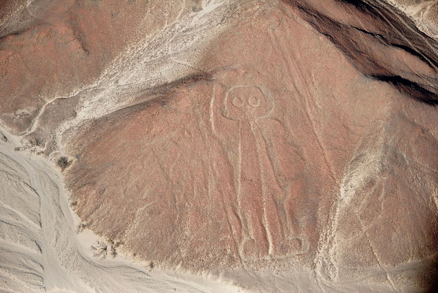
The Biomorphs: Decoding the Hummingbird, The Spider, and The Monkey
The geoglyphs fall into three main categories, but the most iconic are the biomorphs—the animal figures. These are generally considered to be the oldest phase of the Nazca Geoglyphs Peru, dating back to the Paracas culture (the precursor to Nazca) or the early Nazca period.
The zoomorphic choices are telling. The Monkey, the Parrot, and the Pelican are not native to the high desert pampa. The monkey and parrot are Amazonian creatures, implying trade routes that crossed the Andes into the jungle. The spider (specifically the Ricinulei) is found in the rainforest.
These figures represent a connection to distant, water-rich lands. By carving these exotic animals into the dry earth, the Nazca may have been invoking the spirits of the rainforest—a place of abundant water—to come to the desert. The figures are drawn with a single continuous line, reinforcing the theory that they were walked as a ritual path, the faithful following the outline of the sacred beast.
The Great Geometric Grid: Trapezoids and the "Landing Strips" Myth
Overlaying the delicate animal figures are massive geometric shapes: broad trapezoids, triangles, and zig-zag lines. These are generally younger than the biomorphs. In many places, a massive trapezoid ruthlessly cuts through an animal figure, decapitating it or erasing it.
This superimposition suggests a shift in theology. As the climate became drier and the environment more hostile, the delicate animal invocations were deemed insufficient. The society shifted to larger, more labor-intensive geometric forms, capable of holding hundreds or thousands of people. These broad clearings—often mistaken for "landing strips" by pseudo-scientists—were likely open-air temples for mass congregation. They represent an escalation of ritual, a society shouting louder as the gods grew deafer.
The Great Collapse: When the Gods Stopped Listening
The tragedy of the Nazca is that their prayers ultimately failed. Around 500-600 AD, the region was hit by a series of mega-Niño events, causing catastrophic flooding that buried the irrigation canals in mud, followed by decades of punishing drought.
The archaeological record shows a unraveling of society. Cahuachi was abandoned, its pyramids sealed with clay. The construction of lines became more chaotic, more desperate. Nazca Civilization History ends not with a bang, but with a dispersal. The people abandoned the lower valleys and moved into the highlands, absorbed by the rising Wari Empire. The lines were left to the silence of the pampa, a record of a culture that had exhausted its spiritual and ecological capital.
A Fragile Legacy: Preservation in the Anthropocene
Today, the greatest threat to the Nazca Lines is not the wind or the rain, but the Anthropocene. The construction of the Pan-American Highway bisected the pampa, inadvertently cutting the figure of the Lizard in two—a permanent scar of modernity.
Squatters, illegal mining operations, and land traffickers constantly encroach on the protected boundaries. In 2018, a truck driver plowed a semi-trailer over the lines, leaving deep ruts in the ancient canvas. Even well-meaning actions can be destructive; in 2014, Greenpeace activists damaged the Hummingbird geoglyph by walking near it to place a protest banner, disturbing the fragile patina that Maria Reiche spent a lifetime protecting.
Climate change also looms. Increased rainfall in the region, a byproduct of shifting global weather patterns, threatens to wash away the gypsum sublayer that holds the lines together.
Wings Over the Desert: Logistics of Nazca Lines Overflights
To truly comprehend the scale, one must take to the sky. Nazca Lines Overflights depart primarily from the Maria Reiche Neuman Airport in the town of Nazca.
Logistics & Cost:Flights typically cost between $80 and $120 USD, plus a local airport tax. The aircraft are small—Cessna 206s or similar—carrying 4 to 6 passengers.The Experience:It is not a leisure cruise. The pilots execute steep banks (up to 45 degrees) to allow passengers on both sides to see the glyphs. Turbulence is common due to the heat rising from the desert floor. Motion sickness is the rule, not the exception; taking medication beforehand is strongly advised.Safety:Following a series of accidents in the late 2000s, safety regulations have been significantly tightened. Ensure you fly with a reputable operator that adheres to strict maintenance schedules.
The Mirador Observation Tower: A Limited Perspective
For those unable to fly, there is the Mirador, an observation tower located along the Pan-American Highway.
The View:From the top of the metal structure, you can see the Tree and the Hands (sometimes called the Frog).The Comparison:While it offers a moment of connection, the tower is ultimately a disappointment compared to the air. The angle is too shallow to appreciate the geometry. It serves as a stark reminder: these lines were never meant to be seen from the ground. Standing on the tower, you are still a terrestrial observer trying to peer into a celestial conversation.
Ethical Viewing: Responsible Tourism in a Sacred Landscape
Visiting the lines comes with an ethical burden. The pampa is a closed zone. Walking on it is strictly prohibited and constitutes a federal crime in Peru. The footprints you leave today could ruin the aesthetic integrity of the site for generations.
Responsible tourism means:
- Do not support illegal tours: Never pay a local guide to take you onto the pampa in a private vehicle or on foot.
- Respect the flight rules: Fly with certified carriers that respect the altitude restrictions designed to minimize noise pollution and vibration damage.
- Support local museums: Visit the Antonini Museum in Nazca to understand the context of the artifacts and the people, rather than just consuming the visual spectacle of the lines.
Conclusion: The Endurance of Vain Grandeur
As the Cessna touches down on the tarmac, the engine cuts, and the deafness of the desert returns. You are left with a profound sense of melancholy. The Nazca Lines are a testament to the endurance of vain grandeur. They are the world’s most permanent record of an unanswered prayer.
We look down at them today with wonder, but we must remember they were born of fear. They represent a civilization that poured its remaining energy into the earth, carving massive gargoyles and geometries in a frantic bid to bargain with the climate. In the end, the water did not come, and the people vanished.
The lines remain as a Warning in Stone. They remind us that human ingenuity, no matter how monumental, is fragile in the face of environmental collapse. The Nazca people left us a letter we are just beginning to read, a message about the limits of faith and the absolute indifference of nature.
Sources & References
- UNESCO World Heritage Centre: "Lines and Geoglyphs of Nasca and Palpa." UNESCO World Heritage List.
- Reiche, Maria. Mystery on the Desert. Nazi: Nazca Lines, 1949 (and subsequent editions).
- Reinhard, Johan. "The Nazca Lines: A New Perspective on their Origin and Meaning." Editorial Los Pinos, 1986.
- Aveni, Anthony F. Between the Lines: The Mystery of the Giant Ground Drawings of Ancient Nasca, Peru. University of Texas Press, 2000.
- Silverman, Helaine. Cahuachi in the Ancient Nasca World. University of Iowa Press, 1993.
- Lambers, Karsten. The Geoglyphs of Palpa, Peru: Documentation, Analysis, and Interpretation. Lindensoft, 2006.
- National Geographic. "Nasca Lines: The Sacred Landscape." National Geographic Magazine, various articles.
- Sauerbier, Martin. "GIS-based management and analysis of the geoglyphs in the Palpa region." ETH Zurich, 2009.
- Vaughn, Kevin J. The Ancient Andean Village: Marcaya in Prehispanic Nasca. University of Arizona Press, 2009.
- Schreiber, Katharina & Lancho Rojas, Josue. Irrigation and Society in the Peruvian Desert: The Puquios of Nasca. Lexington Books, 2003.
- Rundle, Michael. "Greenpeace apologises for Nazca Lines stunt." Wired UK, 2014.
- Peruvian Ministry of Culture. Official reports on conservation and tourism management in the Nazca region.
- Isla, Johny & Reindel, Markus. "New Studies on the Settlements and Geoglyphs in Palpa, Peru." Andean Past, 2005.
- Hesse, Ralf. "Palaeoenvironmental changes in the Nazca-Palpa region." Heidelberg University, 2008.
- Eeckhout, Peter. "The Archaeology of the Nazca Valley." Bulletin de l'Institut Français d'Études Andines, 2004.