Defining the Neolithic Monolith of Wiltshire
The Anchor of the Salisbury Plain
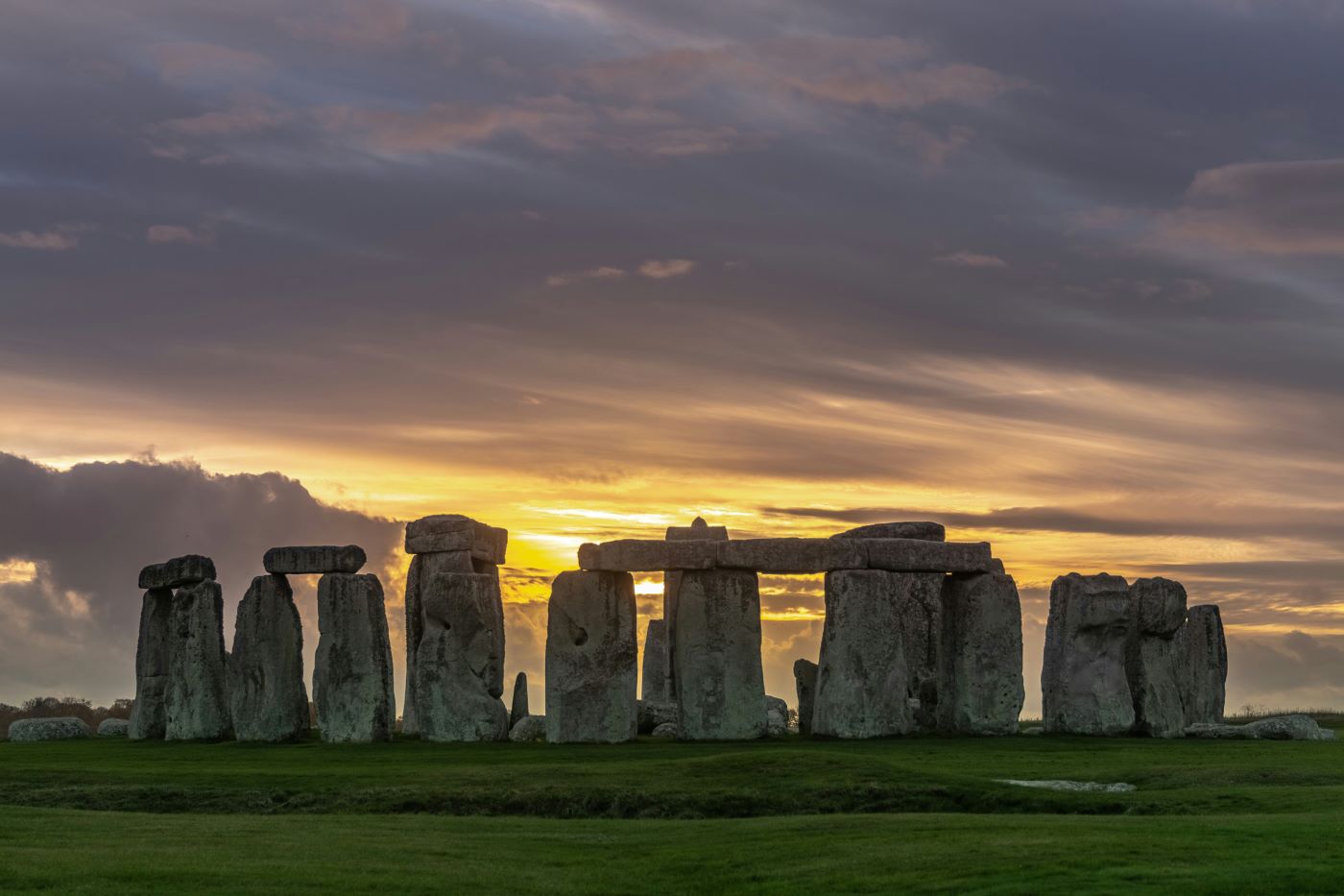
The wind on the Salisbury Plain possesses a distinct, biting clarity, unhindered by the forests that cloak much of the surrounding English countryside. Here, in the heart of Wiltshire, the landscape opens up into a vast, undulating canvas of chalk and grass. It is within this stark theater that Stonehenge stands, not as a random accumulation of rocks dropped by giants, but as a deliberate exercise in Neolithic civil engineering. To approach it is to understand that the setting is as important as the stone. The monument dominates the skyline, a gray, jagged crown sitting atop the green turf, visible for miles in every direction. It is a structure that demands attention, anchoring the viewer to a specific point on the map where the earth seems to rise up to meet the sky.
A Masterpiece of Megalithic Engineering
To define Stonehenge requires stripping away the Victorian romanticism that has clung to it for centuries and facing the raw logistics of its physical reality. It is neither a Druidic temple nor a supernatural manifestation, but a complex earthwork and megalithic arrangement. It is a testament to a civilization that possessed a sophisticated understanding of geometry, leverage, and celestial mechanics long before the arrival of written history. The site is defined by the stark contrast of its materials: the massive sarsen sandstones, hard as iron and weighing as much as a fully loaded coach, and the smaller, spotted dolerite bluestones. Unlike other stone circles in the British Isles, which often consist of unshaped boulders, Stonehenge is unique in its architectural refinement. The stones were not merely erected; they were dressed, smoothed, and shaped to fit a precise geometric vision.
The Stakes of Prehistoric Construction
The existence of Stonehenge represents a project of immense, multi-generational stakes. The builders, lacking the wheel, pulleys, or metal tools, undertook a labor of almost inconceivable difficulty. This was not a weekend task for a small village, but a centralized effort that likely mobilized the resources of the entire island. They sourced the smaller bluestones from the Preseli Hills in Pembrokeshire, Wales, dragging them over one hundred and forty miles across land and water. The larger sarsens were hauled from the Marlborough Downs, twenty miles to the north. The sheer caloric expenditure required to move these monoliths suggests a society with a significant surplus of food and a powerful social or religious hierarchy capable of commanding thousands of workers. It is a site that represents a triumph of logistics over terrain, a refusal to accept the limitations of the local geology.
The Anatomy of the Landscape: Chalk, Rivers, and Sacred Geography
Why Geography Was Destiny for the Stone Circle
Geography acts as destiny on the Salisbury Plain. The location of Stonehenge is not accidental; it is a direct consequence of the underlying geology of Southern England. The region sits upon a vast plateau of chalk, a soft, white limestone that drains water efficiently and prevents the dense growth of woodland. In the Neolithic period, roughly 4,000 to 2,500 BC, while much of Britain was covered in a suffocating canopy of ancient deciduous forest, the chalk downlands remained open. These were natural clearings that offered long sightlines and an unobstructed view of the horizon. This openness was crucial for a culture obsessed with the observation of the sun, moon, and stars. The plain served as a natural stage, a high table where the movements of the heavens could be tracked against the stillness of the earth without the interference of the tree line.
The Avenue and the Processional Route to the River Avon
The monument does not exist in a vacuum but serves as the terminus of a meticulously planned sacred landscape. The primary approach, known as the Avenue, is a prehistoric processional route composed of parallel banks and ditches that wind across the undulating ground for nearly two miles. This ancient roadway links the stone circle to the River Avon at West Amesbury. The connection suggests a ritualistic pathway between the living water and the petrified dead, a route that may have been used to transport the bluestones or to conduct funeral processions. The Avenue is aligned with the sunrise of the summer solstice, guiding the eye and the walker toward the monument's center. It is an intricate manipulation of perspective, designed to heighten the psychological impact of approaching the stones, hiding and revealing the monument as one traverses the dipping terrain.
A Necropolis of Earth: Barrows, the Cursus, and Durrington Walls
To understand the scale of Stonehenge, one must view the plain as a necropolis. The stone circle sits at the center of the densest concentration of burial mounds in Britain. To the north lies the Cursus, a massive Neolithic earthwork enclosure stretching nearly two miles in length, resembling a giant racecourse stamped into the chalk. To the east are the Durrington Walls, the site of a vast settlement where the builders likely lived, feasted, and deposited their trash. The surrounding landscape is scarred with long barrows and round barrows, grassy tumuli that house the remains of chieftains, elders, and the elite of the Bronze Age. This density of funerary architecture suggests that the area was not merely a temple, but a threshold between worlds, a designated zone where the ancestors were anchored to the land through the permanence of stone and the shaping of the chalk earth.
The Legends of Stonehenge: From Merlin to the Druids
The Myth of the Builders and the Giants' Dance
Before the advent of modern archaeology, the silence of the stones was filled with the noise of folklore. The "Myth of the Builders" is a fascinating sociological study in how humans attempt to rationalize the impossible. In the 12th century, the cleric Geoffrey of Monmouth penned the Historia Regum Britanniae, a text that codified the legend of the "Giants' Dance." According to this medieval pseudo-history, the stones were originally healing rocks located on Mount Killaraus in Ireland. The wizard Merlin, acting on the orders of King Aurelius Ambrosius, supposedly dismantled the circle and magically transported it across the sea to the Salisbury Plain. The purpose was to serve as a memorial for British nobles treacherously slaughtered by Saxons during a peace conference. This narrative dominated the popular imagination for centuries, stripping the Neolithic builders of their agency and attributing their engineering prowess to the supernatural intervention of a wizard.
The Druidic Fallacy and the 18th-Century Revival
This magical thinking evolved into the Druidic fallacy of the 17th and 18th centuries. Antiquarians like John Aubrey and William Stukeley, struck by the majesty of the ruins and lacking any method of dating them, confidently proclaimed Stonehenge to be a temple of the Druids, the priestly class of the Iron Age Celts. Stukeley, in particular, popularized the image of white-robed figures performing solstice rituals and sacrifices amidst the sarsens. This association became so deeply embedded in the British cultural consciousness that it sparked a neo-Druidic revival that persists to this day. It is a compelling romantic image, yet it is a historical impossibility. Carbon dating has since proven that the Druids did not arrive in Britain until nearly a thousand years after Stonehenge was completed. The builders of the stone circle had long since vanished by the time the first Druid set foot on the chalk.
Separating Folklore from Archaeological Reality
The reality is that these legends serve a sociological function rather than a historical one. They reflect a deep-seated human need to connect the monumental past with a recognizable narrative. The idea of Merlin or the Druids makes the stones "speak" in a language that later generations could understand, bridging the gap between the known and the unknown. Yet, by stripping away the wizardry and the Celtic priests, we are left with something far more profound: a society of Neolithic farmers and herders who, without the aid of magic, organized a workforce of thousands to realize a vision that would outlast their own civilization by millennia. The true wonder is not in the myth, but in the human determination to create permanence in a world defined by decay.
The Historical Reality: Timeline of Construction and Excavation
Phase I (3000 BC): The Aubrey Holes and the Earthwork Henge
The scientific deconstruction of Stonehenge reveals a timeline far more complex than a single act of construction. Excavation and radiocarbon dating have peeled back the layers of the site to reveal three distinct phases of evolution, spanning over fifteen hundred years. The first phase, beginning around 3000 BC, bore little resemblance to the iconic silhouette seen today. It was a circular earthwork enclosure, a "henge" defined by a ditch and a high inner bank of white chalk. Within this enclosure were dug fifty-six pits, now known as the Aubrey Holes. Excavations have revealed that these holes likely held timber posts or served as cremation burials. This early version of Stonehenge was a cemetery, a place of the dead enclosed by brilliant white walls that would have stood out starkly against the green grass.
Phase II (2500 BC): The Arrival of the Welsh Bluestones
The second phase, arriving around 2500 BC, marked the transition from wood and earth to stone. This was the era of the bluestones. These smaller monoliths, weighing between two and five tons, were arranged in a double crescent at the center of the site. Recent theories, such as the "Blue Stonehenge" hypothesis, suggest that these stones may have originally stood in a circle near the River Avon before being dismantled and moved uphill to their current location. This phase represents a massive expansion of the site's ritual significance, linking the river to the plateau. The transport of these stones from Wales remains one of the greatest mysteries of British archaeology, with theories ranging from glacial transport to human haulage via a network of coastal rafts and rollers.
Phase III: The Sarsen Circle and the Trilithon Horseshoe
The final and most dramatic phase saw the arrival of the sarsens from the Marlborough Downs. The builders erected the massive outer circle of thirty upright stones, capped by a continuous ring of horizontal lintels. Inside this circle, they placed five giant trilithons—structures consisting of two uprights and one lintel—arranged in a horseshoe shape opening towards the northeast. The engineering displayed here is unique among prehistoric monuments. The builders did not simply stack the stones; they shaped them. They used stone mauls to smooth the sarsen surfaces and carved mortise and tenon joints to lock the uprights and lintels together, a technique borrowed directly from woodworking. They even shaped the lintels with a slight curve to maintain the geometry of the circle and tapered the uprights to correct for perspective. This was not rough piling; it was precision architecture designed to withstand the ages.
Visiting Stonehenge: The Modern Experience and Solstice Alignments
Navigating the English Heritage Visitor Center
The modern experience of visiting Stonehenge is a study in managed preservation. The site is operated by English Heritage, which has tasked itself with the delicate balance of protecting the archaeology while accommodating over a million visitors annually. The journey begins at the visitor center, a modern, environmentally integrated structure located over a mile from the stones to preserve the sanctity of the immediate landscape. Here, the context is set through museum exhibits displaying the tools, pottery, and remains found on the site. From the center, visitors take a shuttle bus or walk through the open landscape, approaching the monument slowly. This distance is intentional; it allows the monument to grow on the horizon, restoring some of the awe that the original builders intended for those approaching via the Avenue.
Stone Circle Access and the Inner Sanctum
During standard operating hours, the experience is strictly controlled. A low rope barrier encircles the monument, keeping the crowds at a respectful distance. This separation is necessary to prevent erosion of the earth and damage to the lichen-crusted surfaces of the stones. From the path, the monument appears as a unified mass, but the details of the carvings and the joints are often lost. However, for those who seek a deeper connection, there are "Stone Circle Access" visits offered outside of public opening hours. During these twilight sessions, the barriers are removed, and a limited number of people are permitted to walk among the megaliths. Inside the circle, the scale of the sarsens becomes overwhelming. The texture of the stone, rough and cold to the touch, and the precise fitting of the joints become visible. It is in these quiet moments, when the sun dips below the horizon and the shadows lengthen across the grass, that the true power of the architecture is felt.
The Summer and Winter Solstices: A Modern Pilgrimage
The most intense convergence of past and present occurs during the summer and winter solstices. On these days, English Heritage institutes "managed open access," allowing thousands of people to gather within the stones to watch the sunrise or sunset. It is a chaotic, vibrant mix of neo-Druids, tourists, locals, and travelers. The atmosphere is charged with a strange energy, a blend of festival and church. As the sun aligns with the Heel Stone and the rays strike the center of the monument, the sociological phenomenon becomes the spectacle. It is a modern pilgrimage that mirrors the ancient gatherings, a collective human impulse to witness the turning of the celestial gears. While the summer solstice draws the largest crowds, many archaeologists believe the winter solstice was the more significant event for the builders—a time to feast and pray for the return of the light in the depths of winter.
The Architecture of Time and Human Permanence
Solar Alignment and the Neolithic Calendar
Stonehenge is ultimately a machine for marking time. Its axis is locked to the solar cycle, specifically the midsummer sunrise and the midwinter sunset. The precision of this alignment implies that the monument functioned as a calendar, a way for an agricultural society to track the changing seasons and know when to plant and when to harvest. But it was likely more than just a farmer's almanac; it was a religious instrument. The alignment forces the observer to look up and recognize the cyclical nature of the universe, anchoring the fleeting human lifespan to the eternal rotation of the stars. The light of the sun, framed by the stone trilithons, becomes a sacred event, a reassurance that the order of the world is intact.
Endurance in the Chalk
The monument stands as a defiant assertion of permanence in an impermanent world. The people who built it lived in timber houses that have long since rotted away; their clothes, their language, and their names have vanished into the soil. Yet, they dragged these stones from the mountains and the downs, shaping them with an intensity of purpose that defies the erosion of millennia. In the silence of the Salisbury Plain, Stonehenge remains a profound statement of the human condition: the desire to carve a mark into the earth that says, "We were here," and to ensure that the message lasts long after the voices have fallen silent. It is a reminder that while civilizations may rise and fall, the desire to touch the eternal remains constant.
FAQ
Why are the stones at Stonehenge called "Sarsens" and "Bluestones"?
The term "sarsen" is derived from the medieval word saracen (meaning a stranger or non-Christian), used by locals to describe the massive sandstone blocks found on the Marlborough Downs. They are remnants of a sedimentary layer that once covered the chalk. "Bluestones" is a collective term for the smaller foreign stones, primarily dolerite and rhyolite. While they look gray to the naked eye, they take on a bluish hue when wet or when freshly broken, which distinguishes them from the local rock.
Can you touch the stones at Stonehenge?
During general admission hours, touching the stones is strictly prohibited. Visitors must remain behind a rope barrier that circles the monument to protect the fragile archaeology and rare lichens growing on the rock surfaces. However, English Heritage offers "Stone Circle Access" passes, which are pre-booked visits outside of normal operating hours (early morning or late evening). During these sessions, visitors are allowed to enter the inner circle, though touching is still generally discouraged to preserve the stone.
Is Stonehenge a perfect circle?
The outer sarsen circle was originally designed to be a perfect circle, but it is no longer complete. Of the original thirty upright sarsens, only seventeen remain standing. The lintels that once formed a continuous ring are also largely missing, with only six remaining in place. The inner arrangement is a horseshoe shape, not a circle. The visual gaps are due to thousands of years of weathering, stone theft for local building projects, and structural collapses.
Did slaves build Stonehenge?
There is no archaeological evidence to support the idea of a slave workforce. The construction of Stonehenge occurred in a Neolithic society that likely operated on a system of communal obligation or religious devotion. The isotope analysis of cattle teeth found at the nearby Durrington Walls suggests that people traveled from as far away as Scotland to participate in the construction and the associated feasting. This implies a unified cultural effort or pilgrimage rather than forced labor.
Sources & References
- Stonehenge: History and Stories - English Heritage (2024)
- Researching Stonehenge: Theories Past and Present - University College London (2023)
- The Stonehenge Riverside Project - University of Sheffield (2022)
- Stonehenge's Sarsen Stones Origin Mystery Solved - BBC News (2020)
- Origins of the Bluestones at Stonehenge - Antiquity Journal (2015)
- Feasting at the Durrington Walls - PLOS ONE (2020)
- Radiocarbon Dates from the Stonehenge Environs - Archaeology Data Service (2013)
- The Structural History of Stonehenge - Proceedings of the Prehistoric Society (2018)