A Crossing at the Tuquesa River
The river runs brown and fast over loose stones. A woman steps into it with a backpack tied above her shoulders and a child wrapped against her chest. The current is at her knees. By the third step it is at her thighs. She has walked for four days through jungle that nobody back in her country had described to her, not really. A line of strangers moves around her, holding hands, holding each other up. They are Venezuelan and Haitian and Chinese and Ecuadorian and Afghan. They have already paid the men with rifles at the entrance. They have already buried what they could not carry. Somewhere upstream, on previous days, the bodies of other crossers have washed against the same rocks. She does not know that yet. She knows only that the other side of the river is north, and that north is where the road begins again.
This is the Darien Gap. There is no road through it. There has never been a road through it. And for four years, this jungle was the most-used migration corridor in the Western hemisphere.
The story of this place is the story of geography becoming border policy. For five centuries, every empire that has tried to tame the hundred kilometers of jungle between the Caribbean and the Pacific has failed. The Pan-American Highway, the longest road on Earth, runs unbroken from the Alaskan tundra to the Patagonian steppe except here. The asphalt stops at a town called Yaviza, and on the other side it picks up again in a Colombian beach town called Turbo, and the hundred kilometers between them have eaten conquistadors, naval expeditions, road engineers, and migrants without distinction. By the early 2020s, Washington had stopped fighting the jungle and started using it. The Darien became the cheapest border in the hemisphere. Nature does the work no fence ever could.
The Roadless Wilderness Between Yaviza and Turbo
The Darien Gap is the only piece of the Pan-American Highway that does not exist. The road runs roughly 30,000 kilometers from Prudhoe Bay, Alaska, to Ushuaia, Argentina, and is interrupted in exactly one place: a hundred kilometers of rainforest, swamp, river, and ridge between eastern Panama and northwestern Colombia. On the Panamanian side the asphalt ends at Yaviza, a town of around 4,000 people. On the Colombian side it resumes at the Caribbean port of Turbo. In between are the Darien Province of Panama and the Chocó Department of Colombia. There are no roads. There are no power lines. There is no telephone signal. The jungle absorbs all of it.
The Geography That Defeated Every Empire
The land between Yaviza and Turbo is one of the most biologically dense regions on the planet. It receives between three and five meters of rainfall a year. The Darien National Park, a 5,790-square-kilometer UNESCO World Heritage Site established by Panama in 1980, covers most of the Panamanian side. The Serranía del Darién, a low coastal mountain range, runs through the middle of it. The Atrato River swamps blanket much of the Colombian side: vast tracts of standing water and mangrove that have never been mapped accurately.
The region is home to jaguars, harpy eagles, fer-de-lance vipers, bushmasters, and four species of crocodile. The mosquitoes carry malaria. The botfly lays its eggs in human skin. Cholera, dengue, and yellow fever circulate in the rivers. The Spanish colonial empire abandoned its first attempt at colonizing the region, Santa María la Antigua del Darién, founded in 1510, within a generation. The Scottish Darien scheme of 1698 collapsed in two years and bankrupted half of Scotland. Every imperial power that has tried to put a road through this country has eventually walked away.
The Embera, Wounaan, and Guna Peoples of the Darien
The jungle is not empty. Three indigenous nations live in it: the Embera, the Wounaan, and the Guna. The Embera and Wounaan are riverine peoples who build stilted longhouses along the Tuira, Chucunaque, and Sambú river systems. The Guna live primarily on the Caribbean coast and the San Blas archipelago, where they run a semi-autonomous territory, the Comarca Guna Yala, won from Panama in 1925 after an armed uprising.
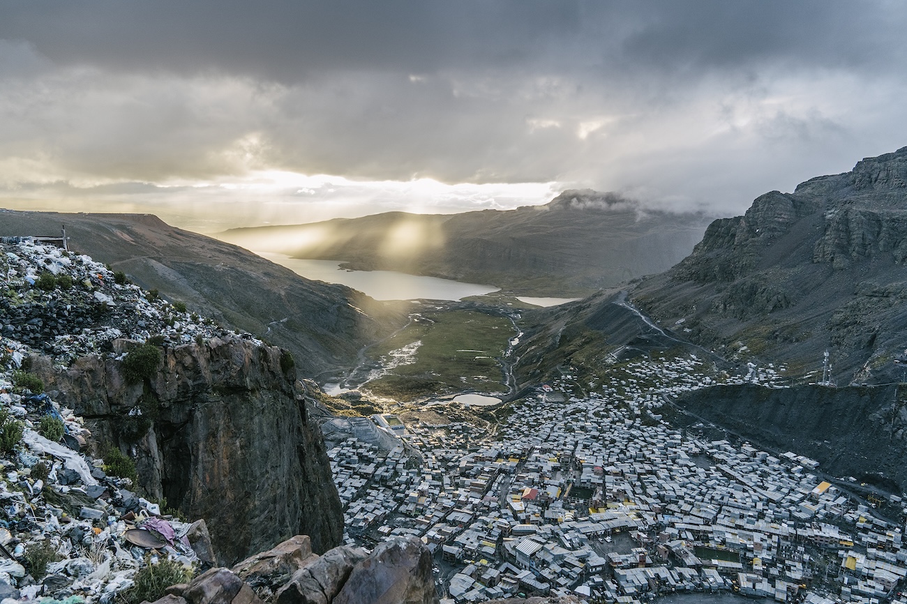
For most of the twentieth century, these communities lived in deep isolation. They traded with the coastal towns. They sent occasional representatives to Panama City. Their territory was almost entirely impassable to outsiders without a guide. After 2021 that changed completely. The Embera village of Bajo Chiquito, the first inhabited place reached by migrants emerging from the jungle on the Panamanian side, became the front line of a humanitarian crisis nobody had planned for. A village of 400 people was suddenly receiving 2,000 strangers a day.
The Pan-American Highway's Only Defeat
Lieutenant Isaac Strain's 1854 Expedition
On the morning of January 17, 1854, the U.S. Navy sloop-of-war Cyane anchored in Caledonia Bay on the Atlantic side of the Darien isthmus. The Cyane carried Lieutenant Isaac G. Strain and twenty-six other men, officers and seamen of the United States Darien Exploring Expedition, dispatched by Secretary of the Navy James C. Dobbin under direct orders from President Franklin Pierce. Their mission was to survey a possible route for a sea-level canal between the Atlantic and the Pacific.
Strain was thirty-three years old. He had explored the interior of Brazil, the Argentine pampas, and the peninsula of Baja California. He carried the journals of an Englishman named Lionel Gisborne, who had crossed the same isthmus a few years earlier and declared it almost level: a forty-mile walk through gentle country. Strain believed him.
What Strain encountered instead was a wilderness that did not match Gisborne's maps in any particular. Rivers ran in directions they were not supposed to run. Mountains stood where Gisborne had drawn flat country. The indigenous guides his party hired in Caledonia Bay vanished into the trees the moment they were paid. Within two weeks the men had run out of food and were chewing on their boots. By the end of their ninety-seven days in the jungle, six of his crew were dead of starvation. The survivors had stripped to bones. They had discussed eating their companions. They emerged on the Pacific coast in March 1854, weighing on average half what they had weighed in January, and reported to Washington that no canal could ever be built across the Darien.
That single expedition closed the question of a Darien canal route in the American government's mind for the next half-century. When the Panama Canal was finally constructed, at the Isthmus of Panama much further west where the country narrows and the terrain flattens, it was built in deliberate avoidance of the Darien country to its east. Strain's bones became the canal builders' compass.
Why the Road Stops at Yaviza
The Pan-American Highway was conceived at the Fifth International Conference of American States in Santiago, Chile, in 1923. The idea was a single road connecting every capital in the Americas. By 1963, every section was complete except the Darien stretch.
There were three serious attempts to close the gap. The first, in the 1950s and 1960s, ran into geological reports identifying the terrain as the worst imaginable for road construction: porous limestone, vertical mudbanks, daily flash floods, six months a year of impassable wet season. The second, in the 1970s, ran into a U.S. Department of Agriculture quarantine concern. Foot-and-mouth disease was endemic in Colombian cattle, and a finished road would expose the disease-free American livestock industry to a continental epidemic. The third, in the 1990s and 2000s, ran into environmental lawsuits from American conservation groups and political resistance from the Embera and Guna nations, who recognized correctly that a road would mean the end of their way of life.
The funding has not returned. The Panamanian government, since 1980, has formally opposed completing the road. The asphalt ends at Yaviza in 1975 and has not advanced a kilometer since.
The Gulf Clan and the Industrialization of the Crossing
The Clan del Golfo and the Toll-Road Cartel
The Darien Gap was not always a migration corridor. For most of the twentieth century the people moving through it were drug traffickers, gold smugglers, and Colombian guerrillas of the FARC and ELN. In the 2010s, a Colombian paramilitary-turned-narco-paramilitary organization called the Autodefensas Gaitanistas de Colombia, better known as the Clan del Golfo or Gulf Clan, consolidated control of the entire Caribbean Colombian coast and the southern entrance to the Darien.
The Gulf Clan was founded in 2008 by remnants of the demobilized United Self-Defenders of Colombia, the right-wing paramilitary federation that had fought the FARC and run cocaine through Urabá for two decades. By 2020 it was the largest criminal organization in Colombia, with an estimated 9,000 armed members and a presence in twenty-four of the country's thirty-two departments. Its territory covered the entire stretch of coast from the Gulf of Urabá to the Panamanian border, every embarkation point on the route to the Darien. Its lineage runs straight back to the same paramilitary economy that produced Hacienda Nápoles and the Medellín Cartel a generation earlier; the cocaine business never left, it just changed its uniform.
When migration through the Gap began to scale in 2021, the Gulf Clan saw a business opportunity that did not require shooting anyone. They built a toll road. For roughly $350 per adult and $200 per child, the cartel sold migrants a guided package: transport from Necoclí to the coastal town of Capurganá, accommodation in tents on the beach, and an armed escort to the Colombian-Panamanian border. The cartel issued receipts. It set fixed prices. It coordinated boat traffic. By 2022, Colombian and U.S. authorities estimated the Gulf Clan was earning around $57 million a year from migrants alone, a side business to its cocaine empire that ran with the efficiency of a regional bus company.
Necoclí, the Beach Town That Became a Migrant Bottleneck
Necoclí is a Caribbean resort town of around 20,000 people on the Gulf of Urabá, six hours by bus from Medellín. Before 2021, it was a quiet fishing and tourism town. After 2021, it became the largest informal migrant staging area in the world.
Migrants arrived in Necoclí from across South America to board the boats to Capurganá, where the jungle began. At its peak, in late 2021 and again in 2023, more than 25,000 people were stranded on the town's beaches at any given time, waiting for boat tickets that the Gulf Clan and its associated boat operators rationed deliberately. Whole families slept on the sand. Children begged. Cholera and dysentery spread. The Colombian government declared multiple states of emergency in the municipality. None of it stopped the flow. Necoclí became the first stop on a corridor that ran 4,000 kilometers from the Colombian Caribbean to the Texas border, and the town's economy reorganized around it within months.
The Numbers That Broke Every Forecast
The crossing figures from Panama's National Migration Service tell the story without commentary.
In 2012, the figure was 3,430. In 2013, it was 3,140. In 2020, 8,594. In 2021, the number jumped to 133,726. In 2022, 248,283. In 2023, 520,085. In 2024, 302,203. In August 2023 alone, just under 82,000 people crossed the Gap, more than the entire annual figure for any year before 2021. By February 2024, 37,166 crossed in a single month. Twelve months later, in February 2025, the figure was 408. By June 2025 it was 10. The calendar year 2025 total was 3,091.
The collapse was not because the jungle had become safer or the journey easier. It was because the political weather in Washington had changed, and the migrants, who are not stupid, had heard.
What Happens Inside the Jungle
The Route from Capurganá to Bajo Chiquito
The crossing takes between four and ten days on foot. From Capurganá or Acandí on the Colombian Caribbean coast, the route climbs steeply through the Serranía del Darién mountain range, crests at the border around 600 meters of elevation, and descends along the headwaters of the Tuquesa and Tuira rivers into Panama. The trail is unmarked. The Gulf Clan's escort ends at the border ridge. After that, migrants are on their own, or in the hands of secondary smugglers whose business model is less regulated and considerably more violent.
The terrain alternates between waist-deep mud, vertical climbs along root systems, river crossings that can rise four meters in an hour during a tropical downpour, and stretches of jungle so dense the column has to walk single file for kilometers. The most dangerous sections are the river crossings on the Panamanian side. The Tuquesa, the Membrillo, and the Marragantí rivers all rise rapidly and have killed thousands of people whose bodies were never recovered. Panamanian authorities recovered 229 bodies between 2021 and 2024. The actual death toll is unknown and almost certainly an order of magnitude higher.
The Rape Trees and the Bodies in the Rivers
Médecins Sans Frontières operated medical points in Bajo Chiquito, Lajas Blancas, and San Vicente from April 2021 to September 2025. In that period the organization conducted 163,000 medical consultations, 8,100 mental health consultations, and treated 1,955 survivors of sexual violence. The vast majority were women, but a significant minority were men.
The crime was systematized. Armed gangs operating on the Panamanian side of the border, distinct from the Gulf Clan but tolerated by it, set up ambush points along the trail. They robbed everyone. They stripped men and women separately. They raped the women in groups and released them to continue. In some sections of the trail, MSF teams documented "rape trees" where the underwear of the victims was deliberately hung as a marker of territory. The Panamanian state, which controls the Darien Province in name only, made no serious attempt to dismantle these operations until 2024.
A 2025 monitoring report jointly issued by the UN Human Rights Regional Office for Central America, the Panamanian Ombudsman, and the Costa Rican Ombudsman found that the vast majority of those who attempted the northward crossing reported having experienced or witnessed violence in transit. The most consistently affected group was women traveling without male relatives.
Bajo Chiquito and the Embera Reception
Bajo Chiquito is an Embera village of around 400 people on the Tuquesa River. It is the first inhabited place that migrants reach on the Panamanian side of the Darien, the place where, after four to ten days in the jungle, exhausted and often injured travelers stagger out of the trees and find food, water, and a phone signal for the first time since Colombia.
The village reorganized its economy around the influx within months. The Embera men charged five dollars per person to ferry migrants in their wooden canoes downriver to Lajas Blancas, the Panamanian government's migrant reception camp. The women sold soup at three dollars a bowl, fried plantains at a dollar, charged phones, sold satellite calls. By 2023 the village was earning more cash in a week than it had in the previous decade. The reaction inside the community was mixed. The elders complained that the language was being lost, that the children watched videos on phones instead of fishing, that the strangers brought disease. The younger Embera, who had hard currency for the first time in their lives, mostly disagreed.
The Embera Cacique General, the highest political authority of the Embera and Wounaan in Panama, issued repeated complaints to the Panamanian government throughout 2022 and 2023, asking for support, security, and recognition. The government's response was to install the Lajas Blancas reception camp downstream and ferry the migrants out as fast as possible. The Embera were left to manage the upstream traffic themselves. Like the indigenous communities around Ciudad Perdida further south, they found themselves administering a piece of territory the state was happy to leave them alone with until the moment it became inconvenient.
The Crisis That Reversed the River
Panama's Mulino Government and the Razor Wire
José Raúl Mulino took office as president of Panama on July 1, 2024. He had campaigned on a single concrete promise: he would close the Darien. Within days of his inauguration, his government installed razor wire along the most-used jungle trails on the Panamanian side, posted border police at the entrances to the camps, and signed an agreement with the United States under which Washington would fund deportation flights of non-Panamanian migrants out of Panama back to their countries of origin.
The numbers began to fall almost immediately. They fell from roughly 30,000 a month in mid-2024 to fewer than 5,000 by the end of the year. They were already collapsing before Donald Trump took the oath of office in Washington on January 20, 2025. What Trump's inauguration did was finish the demolition.
Within hours of being sworn in, the new American president signed Executive Order 14159, "Protecting the American People Against Invasion." The order suspended the CBP One asylum-appointment app, which until that morning had been the principal lawful entry path used by Darien-crossing migrants. It expanded expedited removal procedures. It cut off federal aid to non-governmental organizations supporting migrants in Mexico and Central America. The first deportation flight under the new bilateral agreement landed in Panama on February 13, 2025, carrying migrants from China, India, Iran, and Afghanistan, countries to which the United States had no direct removal agreement. Panama would receive twenty-two such charter flights over the course of 2025.
By February 2025, the monthly crossing figure had fallen to 408. By June, it was 10. The migrants who would have walked through the Darien in 2025 had instead stayed in Caracas, in Port-au-Prince, in Guayaquil, in the Mexican cities at the other end of the corridor like Tijuana, where the route ended for those who had reached that far.
The Reverse Migration of 2025 and 2026
The jungle, which had carried people north for four years, began to carry them south. Through the spring and summer of 2025, migrants who had reached Mexico or the United States and been turned back, or who had abandoned the journey in transit and run out of money, began to retrace the corridor in reverse. By December 2025, more than 22,000 such reverse migrants had passed through Panama heading south, the overwhelming majority of them Venezuelans trying to return home or to resettle in Colombia or Ecuador.
The reverse journey is in some ways more brutal than the original one. The Panamanian government's official position is that southbound migrants are not its problem; it provides no reception infrastructure for them. The boat fare from Colón on the Panamanian Caribbean coast to the Colombian coast costs around $280, which more than half of returning migrants cannot afford. Many are stranded for weeks in remote coastal villages, sleeping in churches, in school courtyards, on beaches. MSF, which had concluded its main Darien operations in early September 2025 amid the collapse of northbound traffic, reopened a three-month emergency response in Colón Province for the reverse flow.
The jungle itself, for the first time in five years, was nearly empty. The Lajas Blancas camp was closed. The Bajo Chiquito river dock, which had handled 2,000 people a day at the peak, handled none. The Embera women who had been selling soup went back to fishing. The Gulf Clan, whose Darien revenues collapsed by an estimated 95 percent, redeployed its men back into the cocaine trade. The trail through the Serranía del Darién began, in places, to be reclaimed by jungle.
The Atlas Entry: Visiting the Edge of the Gap
The Darien Gap is not a place that tourism reaches in any meaningful sense. The interior of the jungle is closed by Panamanian government decree and by the practical reality that no road, no airstrip, and no commercial transport enters it. Independent travel through the corridor is illegal on both the Colombian and Panamanian sides, and the few foreign journalists and researchers who have completed the crossing in the past decade have done so either embedded with migrant convoys or under armed cartel escort.
What can be visited is the edge of the gap. On the Panamanian side, Yaviza, the terminus of the Pan-American Highway and the last point reachable by road, is a six-hour drive from Panama City. Access requires a Panamanian government permit obtained through SENAFRONT, the National Border Service. The town is small and lethargic and surrounded on three sides by impenetrable forest. The road ends. Beyond it is wilderness. The Darien National Park is technically open to visitors at certain marked entrances, but requires advance permits, a registered guide, and often an armed escort. Most travelers do not get past the park headquarters at El Real.
On the Colombian side, Capurganá and Sapzurro on the Caribbean coast, accessible only by boat from Necoclí or Acandí, sit at the literal edge of the jungle. The towns are quiet now. The tourism trade has slowly returned. From Capurganá's main beach, the dense green wall of the Darien begins about a kilometer inland. Local guides will walk visitors to the border itself, where a small concrete marker on a hilltop trail separates Colombia from Panama. From that marker, on a clear day, you can see nothing but rainforest in every direction.
What this place asks of a visitor is not respect for ruins. There are no ruins here. The Darien did not build anything. It only ate things: Spanish conquistadors, Scottish colonists, American naval expeditions, Pan-American Highway engineers, drug-trade fortunes, and most recently a million human beings on their way to somewhere most of them never arrived. Standing at the edge of it, the question is not what was lost. The question is what gets called a border, what gets called a wilderness, and which name a state finds more convenient at any given moment.
Frequently Asked Questions
Where exactly is the Darien Gap?
The Darien Gap is the roughly 100-kilometer stretch of jungle, swamp, and mountain that separates eastern Panama from northwestern Colombia. It spans the Darien Province of Panama and the Chocó Department of Colombia, and contains the Darien National Park on the Panamanian side. On the Pan-American Highway, it sits between the Panamanian town of Yaviza and the Colombian port of Turbo, the only stretch of road missing along the entire 30,000-kilometer route from Alaska to Argentina.
Why does the Pan-American Highway stop at the Darien Gap?
Three successive attempts to complete the road have failed. In the 1950s and 1960s, geological surveys identified the terrain, porous limestone, vertical mudbanks, and a six-month wet season, as the worst imaginable for road building. In the 1970s, the United States blocked completion over fears that finished asphalt would let foot-and-mouth disease spread north from Colombia into the disease-free American cattle industry. In the 1990s and 2000s, environmental lawsuits and resistance from the Embera and Guna indigenous nations halted further plans. The Panamanian government has formally opposed completion since 1980.
How many people have crossed the Darien Gap?
Between 2021 and 2024, around 1.2 million people walked through the Darien Gap on their way north toward the United States, according to Panama's National Migration Service. The peak year was 2023, with 520,085 crossings, and the peak month was August 2023, with just under 82,000 people in a single month. Crossings then collapsed under the combined pressure of Panama's new border-closure policies and the second Trump administration's immigration crackdown. In June 2025, only 10 migrants crossed.
Is it possible to visit the Darien Gap legally?
The interior of the Darien is effectively closed to tourism on both the Panamanian and Colombian sides. Independent crossings are illegal. Visitors can travel as far as Yaviza on the Panamanian side, with a SENAFRONT permit, and to Capurganá and Sapzurro on the Colombian side, which are accessible only by boat from Necoclí or Acandí. From Capurganá, registered local guides can walk visitors to the international border marker, but no further. Trekking into the Darien National Park requires advance permits, a guide, and often an armed escort.
Who controls the Darien Gap?
No single authority controls the Darien Gap. On the Colombian side, the Caribbean coast and the entrance to the jungle are dominated by the Clan del Golfo, also called the Gulf Clan or Autodefensas Gaitanistas de Colombia, a paramilitary-turned-narco organization with around 9,000 armed members. On the Panamanian side, the Embera, Wounaan, and Guna indigenous nations govern most of the inhabited territory under varying degrees of state recognition, while the Panamanian National Border Service, SENAFRONT, manages the official entry points. Armed gangs operating independently of the Gulf Clan control sections of the trail itself.
Why did Darien Gap crossings collapse 99% in 2025?
The collapse was triggered by two simultaneous policy shifts. Panama's new president, José Raúl Mulino, took office in July 2024 and immediately moved to close the Darien transit camps, install razor wire on the most-used trails, and sign a deportation-flight agreement with the United States. Six months later, in January 2025, the second Trump administration suspended the CBP One asylum app, expanded expedited removals, and launched bilateral deportation operations through Panama. Monthly crossings fell from 37,166 in February 2024 to 408 in February 2025, and to just 10 by June 2025.
Sources
The Darkest Jungle: The True Story of the Darien Expedition and America's Ill-Fated Race to Connect the Seas — Todd Balf (2003)
Darien Exploring Expedition (1854) — Joel Tyler Headley, Harper's New Monthly Magazine (1855)
Migración Irregular por Darién (Statistical Bulletins) — Servicio Nacional de Migración de Panamá (2021-2025)
Monthly Migration Through Panama's Darién Gap — Washington Office on Latin America (WOLA) (2025)
Forced to Flee: A Journey Through the Darién Gap — Médecins Sans Frontières (2023)
MSF Concludes Activities in Panama Amid Drastic Drop in Migration Flows — Médecins Sans Frontières (2025)
Monitoring in Motion for Migrants in the Darien Gap — UN Human Rights Regional Office for Central America (2025)
The AGC: From Drug Lords to Criminal Insurgency — InSight Crime (2022)
Migrant Crossings at the Darien Gap Continue to Plummet — U.S. Department of Homeland Security (2025)
The Pan-American Highway and the Darien Gap Problem — Inter-American Development Bank Historical Archives (1971)
Crossroads: The Darien Gap and the Future of Migration — Refugees International (2024)
The Darien: A National Park Threatened by Migration and Deforestation — UNESCO World Heritage Centre (2024)