The Phantom Waka: Te Wairoa's Warning Before the 1886 Eruption
Thirty-one days of May 1886 had passed without incident when a boatload of tourists and their Māori guides rounded a headland on Lake Tarawera and saw something that should not have been there. A large war canoe — ornate, high-prowed, crewed by standing figures — moved across the water ahead of them in total silence. The tourists called out. The figures did not respond. The canoe held its course, then vanished.
No waka of that description existed on the lake. The Ngāti Tuhourangi people who lived at Te Wairoa had not launched one. The tourists returned to the village shaken, and their account reached Tūhoto Ariki, the aged tohunga who served as the community's spiritual authority. His verdict was immediate and unambiguous. The waka wairua — a spirit canoe — was an omen of death. A catastrophe was coming, and it would take the village with it.
The European residents received this prophecy with the polite condescension that characterised most colonial interactions with Māori spiritual life in the 1880s. Te Wairoa was a prosperous settlement. Tourists arrived by the coachload. Hotels were full. The Pink and White Terraces across the lake generated a steady flow of international visitors, and the local economy depended on it. An old man's warning about a ghost canoe was not enough to interrupt business.
Eleven days later, the mountain exploded.
Te Wairoa's destruction is not simply a story of geological violence. It is a story about what happens when a sacred landscape is converted into a commercial product — and what happens when the people who understood that landscape best are ignored. The Māori communities around Lake Tarawera had lived with the volcanic plateau for centuries, reading its geothermal moods, respecting its tapu boundaries, treating the terraces as part of a living spiritual ecology. The Victorian tourism industry saw something else: a natural wonder to be marketed, a revenue stream with hot springs. Te Wairoa was the place where those two worldviews coexisted, uneasily, until the earth settled the argument.
The Pink and White Terraces: The Eighth Wonder of the Natural World
What Were the Pink and White Terraces?
The Pink and White Terraces were twin formations of cascading silica on the shores of Lake Rotomahana, a small geothermal lake roughly five kilometres from Te Wairoa. Over thousands of years, mineral-rich water from underground hot springs had deposited layer upon layer of silica sinter, creating broad, crescent-shaped terraces that descended from the hillside to the lake's edge like frozen waterfalls. The White Terraces — Te Tarata, meaning "the tattooed rock" — covered roughly three hectares and glowed an almost translucent white. The Pink Terraces — Otukapuarangi, "the fountain of the clouded sky" — were smaller and flushed with a soft rose tint from trace minerals in the water.
Visitors who saw them struggled to describe what they were looking at. The pools were warm enough to bathe in, the silica smooth as porcelain beneath the feet, the colours shifting with the angle of sunlight. European travellers compared them to Pamukkale in Turkey but insisted Te Tarata was finer. By the 1870s, international guidebooks were calling the terraces the eighth wonder of the natural world, and the claim was not contested. No equivalent formation existed anywhere on earth at that scale and in that state of preservation.
Guide Sophia Hinerangi and the Lake Tarawera Tourist Trade
The terraces could only be reached by crossing Lake Rotomahana in a boat, which meant the Māori communities who controlled access to the lake also controlled the tourism economy. Sophia Hinerangi, a Ngāti Tuhourangi woman known internationally as Guide Sophia, became the most famous figure in this arrangement. Fluent in English and Māori, sharp, commercially astute, and by all accounts an electrifying storyteller, Sophia led tourists across the lake and up the terraces for decades. She met visiting dignitaries, was photographed by international press, and built a reputation that extended well beyond New Zealand.
Te Wairoa itself transformed around this trade. The village had been a Māori settlement long before European contact, but by the 1880s it was a hybrid community — Māori families, European hoteliers, a schoolteacher, a trader. The Rotomahana Hotel, run by a settler named Joseph McRae, accommodated tourists who stayed overnight. A second hotel operated nearby. Guide houses and whare lined the village's main path. The entire settlement existed, functionally, as a staging post for one natural attraction five kilometres away.
That dependency made Te Wairoa prosperous. It also made the village existentially fragile. The economy ran on a single geological formation, and the geological formation sat on one of the most active volcanic zones on the planet. The Taupo Volcanic Zone had produced eruptions of extraordinary violence for millennia. The hot springs that built the terraces were themselves evidence of the magma system churning below. Te Wairoa's residents — Māori and European alike — lived on the surface of a system they did not fully understand, and the one man who claimed to understand it had just told them to leave.
The Mount Tarawera Eruption of 10 June 1886
How the Mount Tarawera Eruption Unfolded
The first earthquake struck at approximately 12:30 AM on 10 June 1886. Residents of Te Wairoa and surrounding villages felt the ground roll beneath them — deep, sustained tremors unlike the minor geothermal shudders they were accustomed to. Within an hour, Mount Tarawera's summit began to glow.
What followed was not a conventional cone eruption. The mountain did not blow its top. Instead, a rift tore open along the entire length of the summit ridge — roughly seventeen kilometres of the earth's crust splitting apart in a line. The eruption was basaltic, explosive, and devastating. Columns of ash, rock, and superheated steam shot into the sky. The noise was heard in Auckland, more than 250 kilometres away. Witnesses in Rotorua described the sky turning black, then red, then black again, as lightning crackled through the ash cloud.
The rift did not stop at the mountain. It extended southwest through Lake Rotomahana, detonating the geothermal system beneath the lake floor. The resulting hydrothermal explosions were among the most violent phases of the entire event — the superheated water and steam blasting craters into the lakebed, obliterating the shoreline, and sending a pyroclastic surge of mud, ash, and rock across the surrounding landscape.
The Burial of Te Wairoa: What Happened to the Village
Te Wairoa, five kilometres from the rift, was directly in the fallout path. Within minutes of the eruption's onset, heavy volcanic debris began raining onto the village. This was not fine ash drifting from a distant plume. It was dense, wet mud mixed with rock fragments — falling in darkness, in freezing winter temperatures, with the ground still shaking beneath the buildings.
Sophia Hinerangi acted fast. She gathered a group of roughly sixty tourists and local Māori into her whare — a solidly built structure with thick walls — and held the door while the village buried itself around them. The whare held. Sophia and every person inside survived the night.
Others were not as fortunate. At the Rotomahana Hotel, Joseph McRae and his family were trapped as the building's roof collapsed under the weight of falling mud. McRae's wife and several of their children died in the wreckage. McRae himself survived, badly injured, and spent the remaining hours of darkness pinned in the ruins, listening to the mountain tear itself apart.
The schoolteacher's house collapsed. Whare across the village buckled. The Māori settlement of Moura, closer to the mountain, was buried entirely — almost no one survived. Further along the rift, the villages of Te Ariki and Waingongoro were obliterated with little warning and even less chance of escape. These smaller communities are often absent from popular accounts of the disaster, which tend to focus on Te Wairoa's European tourists. The Māori death toll across all affected settlements was significantly higher than the European one.
Mount Tarawera Eruption Death Toll and Rescue
By morning on 10 June, the eruption was subsiding, but Te Wairoa was unrecognisable. The village lay under a thick blanket of mud and ash — in places over two metres deep. Trees had been stripped bare or buried to their branches. The air was choked with fine particulate. The landscape between Te Wairoa and Lake Rotomahana had been rearranged: new craters had opened, streams had been dammed or redirected, and the lake itself had changed shape.
Rescue parties began arriving from Rotorua later that day, working through ash and debris to reach survivors. The confirmed death toll across all affected villages exceeded 120 people, though the exact number remains uncertain — some Māori communities did not maintain European-style records, and the burial of entire settlements made body recovery incomplete. Contemporary estimates ranged from 120 to over 150.
Tūhoto Ariki: The Tohunga Who Survived Four Days Buried in Volcanic Ash
The search for survivors continued for days after the eruption. On 14 June — four full days after the mountain had torn itself open — rescuers digging through the collapsed remains of a whare near the edge of the village heard a voice beneath the rubble.
Tūhoto Ariki was alive.
The tohunga had been buried under the wreckage of his home, trapped in a pocket of air beneath collapsed timber and volcanic debris. He was severely burned, dehydrated, and injured. He was also reportedly over one hundred years old, though his exact age is disputed — some accounts place him in his eighties. Regardless of the precise number, his survival was extraordinary. He had lain beneath metres of ash and rubble through four winter nights, in temperatures near freezing, without food or water, while the landscape above him cooled and settled.
His rescue made headlines across New Zealand and internationally. The man who had predicted the eruption — who had read the phantom waka as a death omen and warned the village to leave — had outlasted the disaster itself. The story had the structure of myth, but it was documented by multiple eyewitnesses and recorded in official rescue reports.
What followed was less mythic and more familiar. Tūhoto Ariki was taken to Rotorua, where he was housed in a tent and — according to multiple contemporary Māori accounts — put on public display. European visitors came to see the old priest who had predicted the eruption and survived burial. He was exhibited like a curiosity, a living artefact of the disaster. He died within weeks of his rescue, and his community attributed his death directly to the stress and indignity of his treatment. The man who had understood the mountain better than anyone was, in the end, consumed not by the eruption but by the same tourism economy that had ignored his warning.
How the Pink and White Terraces Were Destroyed
The Loss of Te Tarata and Otukapuarangi
The Pink and White Terraces ceased to exist on the night of 10 June 1886. The hydrothermal explosions that ripped through Lake Rotomahana destroyed the formations entirely — or so it was believed for over a century. The lake itself was transformed beyond recognition. Before the eruption, Rotomahana had been a small, warm, geothermally active lake. After it, a massive crater lake filled the void left by the explosions, swallowing the original shoreline and everything on it. The terraces — Te Tarata and Otukapuarangi — disappeared beneath the new lake's surface.
The loss was felt globally. The eighth wonder of the natural world had been erased in a single night, and nothing comparable existed to replace it. Victorian-era photographs and paintings became the only surviving records of formations that had taken thousands of years to build. For the Ngāti Tuhourangi, the loss was deeper than scenic — the terraces were taonga, treasures of spiritual and ancestral significance, and their destruction was a wound in the cultural landscape that persists today.
In 2011, a research team from the University of Waikato and GNS Science conducted sonar surveys of the expanded Lake Rotomahana and announced that they had identified what appeared to be remnants of the Pink Terraces on the lake floor, partially intact beneath layers of sediment. The findings were contested — subsequent studies questioned whether the formations were genuinely terrace remnants or new geothermal deposits — but the possibility that fragments of Otukapuarangi might survive, buried underwater, remains an open line of scientific inquiry.
The Excavation of Te Wairoa: New Zealand's Buried Village Uncovered
The buried village lay largely undisturbed for decades. Vegetation reclaimed the site. The ash compacted into a dense layer of soil. Te Wairoa became a place name associated with a historical event rather than a physical location — until systematic excavation began in the 1930s.
What emerged was a volcanic time capsule. The ash had sealed the village so completely that building foundations, domestic tools, cooking implements, and personal belongings were preserved in situ, frozen in the positions they had occupied on an ordinary winter evening. A whare's walls still stood to partial height. Iron pots sat in cold hearths. Glass bottles lay where they had fallen from shelves. Pompeii had been sealed by Vesuvius in the same way — kitchens mid-meal, shops mid-transaction, bodies mid-flight — and had taken nearly two centuries of excavation to reveal the full texture of a Roman city frozen in a single afternoon. Te Wairoa offered the same forensic gift on a smaller, more intimate scale: not a metropolis but a village, not an ancient civilisation but a community within living memory, its Māori and European artefacts lying side by side in the same ash layer.
The excavations continued in phases through the twentieth century, each campaign revealing more of the village's layout and material culture. Tūhoto Ariki's whare was identified and partially excavated. The foundations of the Rotomahana Hotel were uncovered. The site yielded taonga alongside European trade goods, iron tools next to carved Māori implements — a physical record of the hybrid community that had existed before the eruption, and of the two very different ways of understanding the landscape that community had contained.
Te Wairoa Today: The Buried Village Archaeological Site
Visiting the Buried Village of Te Wairoa: What to See Today
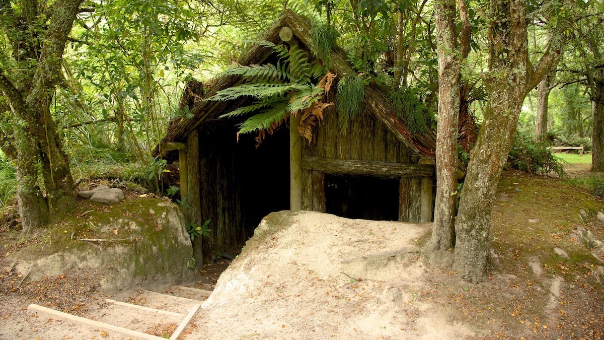
The Buried Village of Te Wairoa operates today as a heritage and archaeological site, located roughly fifteen kilometres from Rotorua on the shore of Lake Tarawera. The site is managed in partnership with the local Ngāti Tuhourangi iwi, and the excavated village foundations, walking trails, and on-site museum form the core of the visitor experience.
The museum houses artefacts recovered from the excavations — domestic items, tools, photographs, and personal effects — alongside a detailed account of the eruption and its aftermath. Outside, visitors walk through the excavated remains of the village itself: the exposed walls of Tūhoto Ariki's whare, the outlines of European-built structures, and the thick ash layer still visible in cross-section along the trail cuttings. The path continues through regenerated bush to Te Wairere Falls, a waterfall that survived the eruption and now cascades through vegetation that has grown over the buried landscape.
The site draws visitors year-round, though it operates on a quieter scale than Rotorua's major geothermal attractions. Guided tours are available and recommended — the guides, many of whom are Ngāti Tuhourangi descendants, provide oral history and cultural context that the museum panels cannot replicate.
How to Get to Te Wairoa and What to Expect
Te Wairoa is accessible by car from Rotorua (approximately twenty minutes) via Tarawera Road. The Buried Village site charges an entry fee that includes museum access, the archaeological walk, and the waterfall trail. Allow two to three hours for a full visit. Lake Tarawera itself is visible from the site and accessible for swimming and boating in warmer months — the mountain that destroyed Te Wairoa rises directly across the water, its rift line still visible along the summit.
Rotorua's geothermal areas — Wai-O-Tapu, Te Puia, and Hell's Gate — are all within a short drive and offer context for the volcanic system that produced the 1886 eruption. Te Wairoa's accessibility makes it unusual among volcanic burial sites. Plymouth, Montserrat — the only other modern capital city buried by an eruption — remains locked inside an exclusion zone nearly three decades after Soufrière Hills consumed it, its buildings still encased in pyroclastic debris with no excavation planned. Te Wairoa's ash has been carefully peeled back. Plymouth's never will be.
Te Wairoa is not a dramatic ruin. The walls are low. The ash is quiet. The bush has grown back. Standing in the excavated village, the most unsettling thing is how ordinary it all looks — foundations of houses, a path between buildings, the outline of a room where someone once slept. The catastrophe is not visible in the ruins. It is visible in the silence: the absolute absence of the community that filled these structures on the last evening anyone lived here. The village stopped mid-sentence, and the sentence is still legible in the dirt.
FAQ
What happened to Te Wairoa in 1886?
Te Wairoa was a Māori-European village on the shores of Lake Tarawera in New Zealand's North Island. On the night of 10 June 1886, Mount Tarawera erupted along a seventeen-kilometre rift, burying Te Wairoa and several surrounding settlements under metres of volcanic mud and ash. Over 120 people were killed across the affected area. The eruption also destroyed the Pink and White Terraces, silica formations on nearby Lake Rotomahana that had been regarded as the eighth natural wonder of the world.
Who was Tūhoto Ariki and how did he survive?
Tūhoto Ariki was an elderly tohunga (Māori spiritual leader) living at Te Wairoa at the time of the eruption. He had publicly warned the village of coming destruction after a phantom war canoe — a waka wairua — was sighted on Lake Tarawera eleven days before the eruption. He was buried under the rubble of his collapsed whare during the disaster and was found alive by rescue parties four days later on 14 June 1886. He died within weeks of his rescue, reportedly weakened by being put on public display for European visitors in Rotorua.
What were the Pink and White Terraces?
The Pink and White Terraces were cascading silica sinter formations on the shores of Lake Rotomahana, near Te Wairoa. The White Terraces (Te Tarata) covered roughly three hectares and the Pink Terraces (Otukapuarangi) were smaller and tinted rose by trace minerals. Built up over thousands of years by geothermal spring deposits, they were considered the eighth wonder of the natural world by Victorian-era travellers. Both formations were destroyed in the Mount Tarawera eruption of 1886, though sonar surveys in 2011 suggested fragments of the Pink Terraces may survive underwater.
Can you visit the Buried Village of Te Wairoa?
The Buried Village of Te Wairoa is an archaeological and heritage site open to visitors year-round, located approximately fifteen kilometres from Rotorua via Tarawera Road. The site includes excavated village foundations, a museum displaying artefacts recovered from the ash, and a walking trail through regenerated bush to Te Wairere Falls. Guided tours are available and recommended, with many guides descended from the Ngāti Tuhourangi iwi who lived at Te Wairoa before the eruption.
Who was Guide Sophia Hinerangi?
Sophia Hinerangi was a Ngāti Tuhourangi woman who became New Zealand's most famous tourist guide in the nineteenth century, leading international visitors across Lake Rotomahana to the Pink and White Terraces. Fluent in English and Māori, she was commercially astute and well known beyond New Zealand. During the 1886 eruption, she sheltered roughly sixty tourists and locals in her reinforced whare and is credited with saving all of their lives.
Is Te Wairoa compared to Pompeii?
The comparison is frequently made and structurally earned. Both Te Wairoa and Pompeii were communities sealed by volcanic material in a matter of hours, preserving buildings, domestic tools, and personal belongings in the positions they occupied at the moment of burial. Te Wairoa's excavation from the 1930s onward revealed a similar time-capsule effect — cooking implements in hearths, glass bottles on shelves, and building foundations intact beneath the ash layer.
Sources
- [The Tarawera Eruption, Lake Rotomahana, and the Origin of the Pink and White Terraces] - R.F. Keam, published in the Journal of Volcanology and Geothermal Research (2016)
- [Te Tarata and Otukapuarangi: Sonar Imaging of the Pink and White Terraces] - de Ronde, C.E.J. et al., GNS Science (2011)
- [The Eruption of Tarawera: A Report to the Surveyor General] - S. Percy Smith, Government Printer, Wellington (1886)
- [Tarawera and the Terraces: The Story of the 1886 Eruption] - Ron Keam, published by the author (1988)
- [Guide Sophia: The Life of Sophia Hinerangi] - Paul Tapsell, in The Dictionary of New Zealand Biography, Te Ara — the Encyclopedia of New Zealand
- [The Phantom Canoe and Other Legends of the Tarawera Eruption] - James Cowan, in Fairy Folk Tales of the Maori (1925)
- [Volcanic Hazards and the Tarawera Rift] - B.F. Houghton et al., Bulletin of Volcanology (2004)
- [The Buried Village of Te Wairoa: Archaeological Investigations 1986–2006] - Alexy Simmons, in Archaeology in New Zealand (2009)
- [Guide to the Hot Lakes District and a History of the Tarawera Eruption] - Charles Blomfield, published by Whitcombe & Tombs (1906)
- [Tūhoto Ariki: Prophecy, Survival, and Cultural Memory in Post-Eruption Rotorua] - Nēpia Mahuika, in Te Pouhere Kōrero: Māori History, Māori People (2015)