The Silent Capital: Geography and the Looming Shadow of Soufrière Hills
On the southern coast of Montserrat, a jagged speck of emerald in the Lesser Antilles, lies the only buried capital city in the modern Western Hemisphere.
Plymouth is not merely an abandoned settlement; it is a metropolitan corpse, a Georgian grid of streets and government seats frozen in a suffocating embrace of andesite and tephra. Once the commercial and cultural heartbeat of the island, Plymouth today is a monochrome study in silence, located deep within the Exclusion Zone V—a designation that marks the boundary between human territory and the sovereign domain of the Soufrière Hills Volcano.
Since the cataclysmic eruptions of 1995–1997, clocks here have remained stopped, possessions lie exactly where they were dropped, and the tropical sun beats down on a grey wasteland where 4,000 people once lived, loved, and traded. To walk here is to tread on the roof of a library or the spire of a church, forcing a confrontation with the terrifying fragility of civilization against the geologic timeline.
The Geology of Soufrière Hills and the Tectonics of Tragedy
To understand the destruction of Plymouth, one must first interrogate the architect of its demise: the Soufrière Hills Volcano. This complex stratovolcano is not a singular conical peak like Mount Fuji, but a chaotic assemblage of lava domes located at the intersection of the Caribbean and North American tectonic plates. The mountain produces andesite lava, a viscous, sticky magma that does not flow like a river but rather piles up, building massive, unstable domes at the summit. These domes grow until they become structurally unsound, eventually collapsing under their own weight.
The topography of Montserrat conspired against its capital. Plymouth was built on a fan of ancient pyroclastic deposits, a geological hint that the volcano had destroyed this specific sector before, thousands of years prior. The terrain above the city formed a natural funnel; the ghauts—steep, ravine-like valleys carved by tropical rains—acted as superhighways for the volcanic debris. When the lava dome collapsed, the resulting pyroclastic density currents were channeled by these ghauts directly into the heart of the city. There was no geological barrier to shield the port; the land itself was shaped to deliver the mountain’s wrath to the sea, with Plymouth standing tragically in the crosshairs. The science of the disaster was written in the landscape long before the first foundation stone of the city was laid, a geographical destiny that remained dormant until the late 20th century.
The Urban Layout of Pre-Eruption Plymouth
Before the sky turned to stone, Plymouth was the quintessential Caribbean capital, renowned for a unique architectural vernacular that blended British Georgian pragmatism with West Indian vibrancy. It was not a sprawling metropolis, but a dense, intimate hub where the island’s administrative, commercial, and maritime lives intersected. The town was laid out in a grid pattern facing the Caribbean Sea, anchored by stone-cut government buildings, a bustling public market, and the blackened sands of the port which served as the island’s primary lifeline to the outside world.
In the early 1990s, the streets were lined with businesses that signaled a thriving, modernizing economy: Barclays Bank, the W.H. Bramble Airport nearby, the cinema, and the distinct stone churches that served as community pillars. The population density was significant for such a small island, with nearly 4,000 of the island's 12,000 residents living within the capital's limits. Visitors described a town of narrow streets and stone-walled warehouses, where the smell of sea salt mixed with the spices of street food. It is vital to visualize this vibrancy—the noise of the taxi stands, the color of the painted shutters, the humidity of the crowded market—to understand the magnitude of the silence that reigns today. This was not a hamlet; it was the seat of government, the center of healthcare, and the repository of the island's history, all situated just four kilometers from the crater of a volcano widely believed to be extinct.
The Psychology of Living in the Shadow of a Sleeping Giant
For generations, the Soufrière Hills were viewed not as a threat, but as a benevolent backdrop to Montserratian life. The mountain provided the fertile soil that allowed the island to live up to its moniker, "The Emerald Isle of the Caribbean." The lush rainforests covering the slopes were sources of water, timber, and recreation. The concept of an eruption was relegated to the realm of distant history, absent from the living memory of the population. There was a profound psychological dissociation between the people and the peril; the volcano was a landscape feature, not a loaded weapon.
This sense of security was shattered not instantly, but through a slow, agonizing erosion of normalcy. When the initial rumblings began, the cultural relationship with the mountain shifted from reverence to betrayal. The psychological trauma inflicted on the residents of Plymouth was unique; they were not immediately wiped out by a sudden blast, but rather subjected to a long siege. They watched the mountain smoke and steam for months, oscillating between the comfort of their homes and the uncertainty of shelters in the north. This period created a complex dissonance, where the familiarity of the daily commute existed alongside the terrifying visual of a growing ash plume. The denial was a survival mechanism. To accept the reality of the volcano was to accept the end of their lives as they knew them, a realization that many fought until the very moment the evacuation orders became mandatory.
Chronicle of Collapse: The Awakening and the Pyroclastic Deluge of 1997
The Seismic Overture: Warning Signs of July 1995
The prelude to the destruction of Plymouth began on July 18, 1995, a date now seared into the collective consciousness of the Montserratian diaspora. It started not with lava, but with steam. Phreatic eruptions—explosions caused by groundwater flashing to steam upon contact with hot magma—heralded the awakening of the Soufrière Hills. For the residents of Plymouth, the initial signs were subtle but ominous: a sulphurous stench drifting on the trade winds and fine layers of dust settling on car windshields.
The initial scientific response was a scramble to deploy monitoring equipment on a mountain that had been largely quiet for 400 years. Seismographs began to scream with harmonic tremors, the rhythmic underground heartbeat that signifies magma moving toward the surface. The chaos of these early weeks was characterized by confusion. Evacuation orders were issued and rescinded in a chaotic rhythm. The southern part of the island, including Plymouth, was evacuated multiple times in late 1995. These were the "dress rehearsals" for the end of the world, creating a logistical nightmare as the government attempted to move a third of the population to the rudimentary facilities in the safer northern zone. It was a time of fear, but also of spectacle, as residents watched the venting steam, unaware that the magma rising beneath them was chemically primed to be explosively violent.
The Era of Uncertainty and the False Hope of 1996
The year 1996 introduced a cruel psychological torture known locally as "yo-yoing." As the volcano's activity waxed and waned, the boundaries of the unsafe zones were constantly redrawn. Residents of Plymouth were periodically allowed to return to their homes to clean off the ash, tend to their businesses, and attempt to reclaim a semblance of normalcy. This created a false sense of hope—a belief that perhaps the worst was over, or that the volcano could be lived with, managed like a moody neighbor.
During these interludes, Plymouth became a surreal landscape. Residents would sweep ash from their porches while wearing dust masks, the grey mountain looming over them, puffing smoke. The government kept essential services running; the banks opened, and the port operated, despite the ever-present threat. This period was critical in the tragedy because it exhausted the population. By the time the final, decisive evacuations were ordered, many were suffering from "evacuation fatigue," a dangerous complacency born of repetition. The fluctuating danger levels eroded trust in the scientific predictions, leading some to stay in the danger zone longer than they should have, protecting their property from looters rather than their lives from the lava. This era of uncertainty paralyzed decision-making, leaving the capital vulnerable when the volcano finally decided to escalate its assault.
The Day the Sky Turned Black: The Cataclysm of August 1997
The final death knell for Plymouth did not come in a single moment, but the decisive blow was struck in August 1997. Following a massive collapse of the lava dome, a series of pyroclastic flows—avalanches of superheated gas and rock—surged down the northern and western flanks of the volcano. While the town had been evacuated of permanent residents, the destruction of the infrastructure was absolute. The eruption on August 3 and the subsequent flows throughout the month turned noon into midnight.
Witnesses from the safe zones and boats offshore described a vertical column of ash collapsing under its own weight, transforming into a horizontal hurricane of black clouds that raced toward the sea. This was not a slow creep of lava; it was a deluge. The flows engulfed the W.H. Bramble Airport, twisting steel girders like wet pasta, before pouring into Plymouth. The heat was so intense it ignited buildings instantly. Wooden structures vaporized; stone buildings were battered by boulders the size of cars carried within the flow. The sky turned a bruised purple-black, blotting out the sun completely. When the cloud lifted, Plymouth was gone. In its place was a grey, smoking moonscape. The harbor, once deep enough for cargo ships, was extended hundreds of meters out to sea by the deposition of millions of tons of volcanic material. The capital had not just been damaged; it had been buried.
Frozen in Ash: The Science of Pyroclastic Preservation and Zone V
Anatomy of a Pyroclastic Flow: Physics, Speed, and Heat
To comprehend the state of Plymouth today, one must understand the physics of the weapon that killed it: the pyroclastic flow, or nuée ardente (glowing cloud). Unlike the slow-moving red rivers of basaltic lava seen in Hawaii, these flows are fluidized mixtures of solid to semi-solid fragments and expanding gases that behave like a liquid but move with the speed of a formula one car. Racing at speeds exceeding 100 kilometers per hour (62 mph) and reaching temperatures of up to 700°C (1,300°F), a pyroclastic flow offers no possibility of escape.
The flows that buried Plymouth were gravity-driven avalanches resulting from the collapse of the lava dome. The gas within the mixture reduces friction between the particles, allowing the mass to travel great distances with terrifying momentum. When this superheated mass hit the buildings of Plymouth, the thermal shock shattered glass and ignited any combustible material instantly. However, as the flow lost momentum and settled, it encased the non-combustible structures—stone walls, concrete foundations, metal safes—in a dense, cohesive matrix. This is why Plymouth is referred to as a modern Pompeii; the mechanism of burial was nearly identical, preserving the hard skeleton of the city while incinerating its soft tissue.
The Stratigraphy of Ruin: Analysis of the Ash Layers
The burial of Plymouth was not a singular event but a stratigraphic process involving distinct layers of deposition. The initial layers were composed of coarse blocks and ash from the pyroclastic surges, which smashed doors and filled the ground floors of buildings. Following the initial eruptions, heavy tropical rains mobilized the loose ash on the volcano's flanks, creating lahars—volcanic mudflows with the consistency of wet concrete.
These lahars flowed into the city, filling the spaces between the pyroclastic debris and rising steadily, floor by floor. As this mud dried, it hardened into a material almost as durable as man-made concrete. Today, an excavation of Plymouth would reveal a timeline of destruction in the soil profile: the pre-1995 soil at the bottom, followed by layers of fine ash from early venting, then the chaotic, rock-filled deposits of the major flows, and finally, the crust of cemented mud. In some areas, the burial is over 12 meters (40 feet) deep. This accretion process means that the "ground level" a visitor walks on today is actually the level of the second-story balconies or the rooftops. The true streets of Plymouth are sealed in an airless, lightless vault beneath meters of hardened earth.
The Creation and Enforcement of the Exclusion Zone (Zone V)
In the wake of the destruction, the government of Montserrat, in conjunction with the British Foreign and Commonwealth Office, established the Exclusion Zone. This area, covering the southern two-thirds of the island, is one of the most strictly regulated geographical entities on Earth. Zone V, which encompasses Plymouth, is the area of highest risk, where entry is legally prohibited without specific authorization.
The zone is not merely a line on a map; it is a physical border patrolled by the Royal Montserrat Police Force. Gates block the roads leading south, and maritime patrols monitor the coastline to prevent unauthorized landings. The classification of Zone V is based on the continuous threat of the volcano, which, though currently in a state of pause, is still active. The dome could collapse again, or explosive activity could resume with little warning. The Exclusion Zone serves a dual purpose: it protects human life from volcanic hazards, but it also inadvertently acts as a preservation seal for the ruins. By restricting human traffic and looting, the zone has kept Plymouth in a state of suspended animation, a time capsule of 1997 protected by the threat of death.
Navigating the Forbidden: Dark Tourism Within the Exclusion Zone
Bureaucracy of the Buried: MVO Permits and Police Escorts
Entering Plymouth is not a simple matter of driving south. It is a logistical operation that requires navigating a web of bureaucracy designed to ensure safety. Access is strictly controlled by the Montserrat Volcano Observatory (MVO) and the police. Prospective visitors must engage a certified tour guide who has undergone specific training in volcanic hazards and emergency evacuation protocols. These guides are the gatekeepers of the grey zone; without one, the gates remain locked.
The process involves radio checks with the observatory to confirm the volcano’s current hazard level. If the sulfur dioxide emissions are too high, or if there is seismic instability, tours are summarily cancelled. Upon entry, visitors are logged in and out, their movements tracked. This rigorous protocol underscores the reality that Plymouth is not a theme park; it is an active disaster zone. The experience begins with a safety briefing that details the sound of a pyroclastic flow and the direction of escape—a sobering reminder that the "attraction" here is a killer that is merely sleeping.
Walking the Grey Wastes: A Sensory Audit of the Dead City
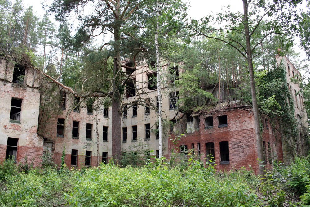
Crossing the Belham River Valley—the effective border of the safe zone—the world changes palette. The vibrant greens of the tropical north fade into a spectrum of greys, rusts, and browns. Walking into Plymouth is a sensory experience defined primarily by what is missing. There is no sound of traffic, no hum of electricity, no birdsong. The silence is heavy, broken only by the wind whistling through hollowed-out windows and the crunch of tephra under boots.
The air in Plymouth tastes different; it is metallic, often laced with the sharp tang of sulfur drifting down from the crater. The heat is intensified by the lack of shade and the dark ground absorbing the tropical sun, creating a convection oven effect. Visually, the scale is disorienting. A visitor might approach a small concrete curb, only to realize it is the top of a door frame. Second-story windows look out at ankle level. The "ground" is littered with the detritus of a panicked evacuation: a rusted typewriter, a twisted bicycle, the skeleton of a bus half-submerged in the road. It is a landscape of profound melancholy, where the sheer volume of the volcanic material forces the brain to constantly recalibrate the scale of the destruction.
Icons of the Fall: The Flora Fountain and the Buried Hotel
Within the sea of grey, certain landmarks serve as navigational beacons and yardsticks for the depth of the burial. The Flora Fountain, once a modest centerpiece of a busy intersection, is now almost entirely swallowed, its top barely poking above the ash like a buoy in a concrete ocean. It allows visitors to visualize the depth of the flow, realizing they are standing ten feet above the original street level.
Perhaps the most striking ruin is that of the Montserrat Springs Hotel. Once a luxury resort, it now stands as a brutalist monument to decay. The pool is filled with ash, a grey solid where blue water once shimmered. The reception desk is entombed, with room keys and ledgers still rotting behind the counter. Papers, menus, and phone books from 1995 lie scattering across the floor, their dates frozen in time. The juxtaposition of leisure and catastrophe is stark here; the ghostly remains of a holiday paradise destroyed by the very nature tourists once came to admire. These icons are not just ruins; they are gravestones for a way of life that ended abruptly on a Tuesday afternoon.
The Impermanence of Empire: Reflections on a Modern Atlantis
The Human Cost of Displacement and the Diaspora
The burial of Plymouth was not just a geological event; it was a demographic catastrophe. The eruption forced the migration of over 7,000 people, more than half of the island's population. Many fled to the United Kingdom, settling in cities like Preston and Birmingham, creating a "Montserrat within a distinct land." This diaspora represents a profound cultural trauma—a generation of islanders who can never go home because "home" is buried under twenty feet of rock.
For those who remained, life shifted to the north of the island, a cramped existence where government offices operate out of converted houses and the sense of temporary displacement has stretched into decades. The loss of Plymouth was the loss of the island’s archive, its ancestral properties, and its gathering places. The grief is palpable in the stories of the elders who remember the music in the streets of Plymouth, a memory that becomes more fragile with each passing year. The tragedy of Plymouth is the tragedy of a severed root system, a community forced to transplant itself while watching its original garden turn to stone.
Nature’s Reclamation and the Future of the Green Island
Yet, even in this desolation, there is a quiet resilience. Nature, indifferent to human tragedy, is beginning to reclaim Plymouth. Tough, pioneer species of ferns and grasses are rooting in the ash, breaking up the concrete crust. The heavy rains carve new channels, slowly excavating parts of the city while burying others deeper. The "Green Island" is fighting the grey.
Plymouth stands as a definitive memento mori for the modern age. It challenges the assumption of permanence that underpins our cities. We build with steel and stone, believing our footprint is indelible, but Plymouth proves that civilization is merely a thin veneer over a volatile planet. As the jungle slowly creeps back over the ruins of the Governor’s House and the vines choke the clock tower, the city serves as a reminder that we are temporary tenants on this earth. The volcano did not destroy Plymouth out of malice; it simply did what volcanoes do, and in the process, it created a monument to the sublime, terrifying power of the natural world—a modern Atlantis that we can still touch, before the jungle finally hides it forever.
FAQ
Is it safe to visit Plymouth today?
Visiting Plymouth is generally considered safe provided strictly defined protocols are followed. The city lies within Zone V, the highest risk area of the Exclusion Zone. Entry is illegal without a police permit and a certified tour guide who is in radio contact with the Montserrat Volcano Observatory (MVO). The MVO constantly monitors seismic activity, gas levels, and dome stability. If the threat level rises, all access is immediately suspended. Visitors should be aware they are entering an active volcanic zone where risks, though mitigated, cannot be entirely eliminated.
Can tourists enter the buried buildings?
Entering the structures themselves is highly discouraged and often forbidden by guides due to severe structural instability. The buildings have been subjected to extreme heat, heavy ash loads, and years of neglect, making roofs and floors prone to collapse. Furthermore, many buildings are buried up to the second floor, meaning "entry" would require climbing through windows into spaces with uncertain floor integrity. Most tours conduct the experience from the street level (which is effectively the second-story level), allowing visitors to look into, but not enter, the ruins.
How does one travel to Montserrat and book a tour?
Montserrat is accessible via a 20-minute flight or a ferry ride from the neighboring island of Antigua. Once on the island (specifically in the safe Northern Zone), visitors must book a tour through a certified operator. These operators handle the necessary paperwork, including the police permits required to cross the Belham River into the Exclusion Zone. It is advisable to book these tours in advance, as they are subject to weather and volcanic conditions.
What is the current status of the Soufrière Hills Volcano?
The volcano is currently classified as being in a state of "unrest." While there has been no major dome collapse or extrusion of lava in recent years, the volcano is not extinct. It continues to emit volcanic gases and exhibits periods of seismic activity. The lava dome remains massive and potentially unstable. The MVO maintains a comprehensive alert level system (0-5), and daily life on the island is dictated by these scientific readings.
Sources & References
- Montserrat Volcano Observatory: Activity Reports & Science - MVO Staff (2024)
- The Soufrière Hills Eruption: A Chronology - Geological Society of London (2002)
- Montserrat: Living with a Volcano - BBC News (2015)
- Polynesian and Caribbean Narratives of Volcanic Displacement - Journal of Postcolonial Writing (2013)
- Ash to Cash: The Economics of Dark Tourism in Montserrat - National Geographic (2019)
- The Exclusion Zone: 20 Years After the Blast - The Guardian (2015)
- Government of Montserrat: Tourism & Access Division - GoM (2023)
- Pyroclastic Density Currents and the Destruction of Plymouth - Smithsonian Institution Global Volcanism Program (1998)
- Geographies of Disaster: The Soufrière Hills Eruption - The Geographical Journal (2008)