The Romanesque Bell Tower That Still Rises From the Reschen Pass Reservoir
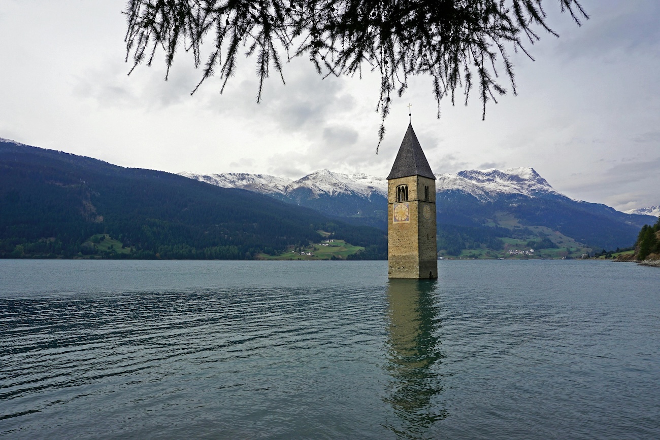
The photograph is one of the most widely reproduced images of Alpine Italy. A square Romanesque tower in pale stone, capped with a steep pyramidal roof, rises directly out of a still glacial lake. Snow-capped mountains stand behind it. In winter, when the lake freezes solid, visitors walk out across the ice and touch the base of the tower. It appears on postcards, on Instagram, on the cover of the Netflix series that took its name from the village that lies beneath it. Most people who photograph it do not know what they are looking at.
The bell tower at the southern end of Lago di Resia is not a ruin. It is not a charming relic of a vanished medieval village that slowly subsided into the water. It is the only remaining structure of a community that was forcibly erased by the Italian state in July 1950, against seven years of organised resistance from the people who lived there. The villagers were German-speakers. The Italian government was the same one that had been democratising itself for five years after the fall of Mussolini. The plan to flood the valley had been approved under fascism in 1939 and was completed under the Republic with a dam four times taller than the original fascist design.
This is the central fact of Lago di Resia, and it does not appear on the postcards. The tower in the photograph is not a relic. It is a tombstone.
The Two South Tyrolean Villages Beneath Lago di Resia
The Reschen Pass is a low Alpine saddle at the top of the Vinschgau valley, where the headwaters of the river Adige rise and the road to the Inn valley climbs over into what is now Austria. The pass has been a trade and military route since Roman times. The valley below it, narrow and high, held a series of small German-speaking farming villages dating to the early Middle Ages. The two that mattered for the dam project were Graun, on the western shore of a small natural lake, and Reschen, two kilometres to the north on a separate smaller lake. Both were Tyrolean villages of perhaps three hundred to five hundred souls. Their economies were cattle and hay and the seasonal traffic over the pass.
The church of St. Catherine at Graun was the village’s central building. Its tower had been raised in the early 14th century in the Romanesque style that was already old-fashioned at the time it was built but standard for South Tyrolean parish churches of that era. The nave and roof were later medieval, with subsequent Baroque interior renovations. The tower carried four bells. The oldest dated to 1530.
The Annexation of South Tyrol and the Italianisation Programme
South Tyrol was Austrian territory until 1919. The Treaty of Saint-Germain, signed at the end of the First World War, transferred the German-speaking province from the dismembered Austro-Hungarian Empire to the Kingdom of Italy. Italy had not been promised the region in the Treaty of London in 1915 only because its strategic value was undeniable; the alpine watershed gave whoever controlled it command of the southern approaches to central Europe. The German-speaking population, roughly two hundred and fifty thousand people, found themselves citizens of a country whose language they did not speak and whose government had no historical claim on their loyalty.
Mussolini’s regime began a systematic Italianisation programme from 1922 onward. German was banned from schools, from official documents, from public signage. Place names were translated into Italian: Bozen became Bolzano, Brixen became Bressanone, Meran became Merano. The village of Graun became Curon Venosta. Reschen became Resia. German-speaking teachers were dismissed and replaced with Italian-speakers from the south. The use of German in public was punishable by fine and, after 1934, by imprisonment. Tens of thousands of Italian workers from the south were resettled into the province to dilute the German-speaking majority. The German Tyroleans called this period the Etschland years and remembered it as foreign occupation rather than national integration.
The dam project at the Reschen Pass was conceived within this political context. The decision to flood two German-speaking villages was not coincidence. It was continuity.
The Montecatini Hydroelectric Scheme and the Mussolini-Era Decision to Flood the Valley
The Montecatini company was one of fascist Italy’s largest industrial conglomerates, with extensive holdings in chemicals, mining, and hydroelectric generation. In the late 1930s the company identified the upper Adige valley as suitable for a major hydroelectric reservoir. The two existing natural lakes at the Reschen Pass — the Reschensee and the Mittersee — could be combined into a single larger artificial lake by damming the river at the south end of the valley. The water would feed turbines downstream and supply power to the industrial north.
The 1939 Approval Under Fascist Italy
The original plan, approved by the Italian government in 1939, called for a dam approximately five metres high. This would have raised the water level of the natural lakes modestly, enlarging the combined reservoir but leaving the villages of Graun and Reschen intact above the new shoreline. A few low-lying meadows and farms would have been lost. The villages themselves would have survived.
Construction was scheduled to begin in 1940. The Second World War intervened. Italy entered the war in June 1940, and major civil engineering projects in the Alpine north were suspended. The 1939 approval sat in Montecatini’s files for the duration of the conflict. South Tyrol was occupied by German forces after Italy’s 1943 armistice and was administered as the Operationszone Alpenvorland until the end of the war. The villagers of Graun and Reschen spent those years in a peculiar limbo — formally Italian citizens, effectively under German rule, fighting in both armies depending on circumstance, waiting to see which state they would belong to when the shooting stopped.
When the war ended, they belonged to Italy. The new Italian Republic, founded in 1946, inherited the fascist-era dam project along with everything else. Montecatini’s engineers reopened the file.
The Postwar Decision to Build Twenty-Two Metres Instead of Five
The critical decision was made in the late 1940s. Montecatini’s engineers and the Italian state’s energy planners revised the dam upward. The new plan called for a structure twenty-two metres high — more than four times the original fascist proposal. The hydroelectric output would more than triple. The reservoir behind the dam would expand from a modest enlargement of the existing lakes into a single body of water nearly six kilometres long.
The villages of Graun and Reschen could not survive the higher plan. At twenty-two metres of impoundment, the valley floor where they stood would lie under more than fifteen metres of water at the deepest point. The 163 houses of Graun, the village’s two churches, its school, its inn, its cemetery, and its centuries of accumulated barns, stables, walls, and paths would all be submerged. The same applied to the smaller settlement at Reschen.
The Italian Republic chose the higher plan. The decision was made on grounds that were officially technical and economic: greater power output, better return on investment, more efficient use of the watershed. The political fact that the lower plan would have spared two German-speaking villages, and the higher plan would not, was not officially part of the calculation. It was, however, the practical outcome.
Seven Years of Legal Resistance and the Cable From Rome That Came Too Late
The villagers organised. The mayor of Graun, Otto Plangger, led a delegation to Rome in 1947. They were received politely and told that the project was a matter of national infrastructure planning and could not be altered. They hired lawyers in Bolzano and filed administrative appeals. The appeals were denied. They wrote to the Vatican, asking for the intervention of Pope Pius XII on the grounds that two consecrated medieval churches were to be destroyed. The Vatican response was sympathetic but non-committal. They sent letters to the German-language press in Austria and Switzerland, where the story attracted coverage and outrage but produced no political pressure capable of stopping the Italian state.
The Bishop of Bressanone, Joseph Gargitter, took up the case in 1949. He wrote directly to the Italian Minister of Public Works arguing that the destruction of the medieval parish church at Graun violated the Lateran Concordat between Italy and the Holy See. The argument was technically correct and politically ignored. The bishop continued to press the case through 1949 and into 1950.
On 8 July 1950, a cable arrived at the parish office in Graun from the Vatican. The content of the cable has been reported in different versions in the South Tyrolean historical literature. The substance was an appeal to the Italian government, communicated through the bishop’s office, for a stay of execution on the flooding. The cable arrived twenty-four hours before the floodgates were opened. It made no difference. The project was already in its final phase, the houses were already demolished, the bells had been removed the previous summer. The Vatican had no mechanism to halt the flow of water from a dam built by an Italian state company under the authority of the Italian Republic. The cable was filed in the parish archive.
The Flooding of Graun in July 1950 and the Erasure of the Village
The mechanical sequence of erasure began the previous year and proceeded with administrative precision.
The Demolition of 163 Houses and the Removal of the Bells
On 18 July 1949, the four bells of the church of St. Catherine were lowered from the tower by a crew working under the supervision of the parish priest, Alfred Rieper. The oldest bell, dated 1530, weighed approximately eight hundred kilograms. The others were 18th and 19th-century replacements. All four were transported out of the valley by truck. Two were eventually rehoused in the new church of Curon Venosta built on the hillside above the lake. The other two were sent to other parishes in the diocese. The tower at Graun was empty for the first time in six centuries.
Through the autumn of 1949 and the spring of 1950, the houses of Graun were systematically dynamited. The decision to demolish rather than allow them to be submerged intact was made on engineering grounds: floating debris in the new reservoir would damage the dam machinery. 163 buildings were reduced to rubble in the months before flooding. The villagers had been compensated at rates determined by state assessors. The payments were small. They covered, in most cases, less than half the cost of replacement housing in the new village being built on higher ground.
The medieval church of St. Catherine was deconsecrated on 18 May 1950 in a final mass attended by most of the displaced villagers. The nave was then demolished. The tower was left standing.
The Eleven Days the Water Rose
The floodgates were opened on 9 July 1950. The valley took eleven days to fill.
The villagers watched from the new settlement on the hillside above. The contemporary accounts collected by South Tyrolean historians in the decades since describe the experience in terms that vary in detail but converge in substance. The water rose slowly at first, filling the low meadows. Then it covered the foundations of the demolished houses. Then it rose above the streets, the village square, the lower walls of the buildings that had been spared demolition because they were too distant from the centre to matter. The two churches were already rubble. The water moved across the floor of the valley in a brown line that advanced by metres each hour.
The bell tower of St. Catherine stood at the centre of what had been the main square. The water reached its base on the third day. By the seventh day it covered the small Romanesque door at the foot of the tower. By the ninth day it stood at the level of the first row of windows. On the eleventh day the rising stopped. The water had reached the planned operating level. The top six metres of the tower remained above the surface. The pyramidal roof, the belfry arches, the upper section of the stone shaft. Below that lay the village.
Why the Tower Was Not Demolished
The decision to leave the tower standing was not sentimental. It was legal. The Romanesque bell tower at Graun was a protected historical monument under heritage protection laws dating to the Austrian period before 1919. South Tyrolean monument protection statutes had been ported into Italian law during the fascist period and retained by the Republic afterward. Demolishing a registered monument required a specific authorisation that the Ministry of Public Works was not willing to seek for a building that could be physically left in place at minimal cost.
The compromise was bureaucratically convenient and visually unforgettable. The valley was drowned. The village was erased. The tower remained, because removing it would have required an additional paperwork step that the Italian state declined to take. The single most photographed image in Alpine Italian tourism exists because of a clerical decision in a Rome ministry to avoid filing one more form.
The Folklore of the Bells Ringing Under the Ice
The bells were removed in July 1949. This is documented. The parish records list the date, the names of the crew, the weights of the four bells, and their eventual destinations in other South Tyrolean parishes. Every adult in Curon Venosta knows this.
The story that the bells still ring continues anyway.
The Local Story That Refuses to Die
Residents of the new Curon Venosta have insisted for seventy-five years that on cold winter nights, when the lake freezes solid and the ice expands and contracts in the temperature swings of the Alpine dark, the church bells of Graun can be heard ringing under the surface. The story is told by people whose grandparents watched the flooding and by their own grandchildren who never saw the original village. It is told to tourists, who often repeat it as fact in travel articles. It is told without irony and without explanation. It is also told without the slightest belief that it is literally true.
The mechanical reality is that the bells are not in the tower. They were transported out of the valley a year before flooding and rehoused in standing churches in Curon Venosta and elsewhere in the diocese, where they continue to ring on Sunday mornings in their new locations. The tower in the lake is empty. The bells that ring on cold winter nights under the ice cannot be ringing because they are not there.
The legend persists because it is not really about acoustics.
How Communities Mourn Through Stories They Know Are Not True
The folklore of the sunken bells is one of the clearest documented cases in European ethnographic literature of a community using a story it knows to be false to express a truth that the historical record cannot hold. The villagers of Curon Venosta lost their homes, their farms, their cemeteries, and their parish church to a state that did not speak their language and did not consider their objections worth answering. The compensation was inadequate. The legal remedies were exhausted. The flood happened. There was nothing left to do.
The story of the bells is the residue of that powerlessness. It is a refusal to accept that the erasure was total. The state took the houses, took the church, took the bells themselves, but it cannot take the sound the bells once made, and on cold nights when the ice cracks and groans across the surface of the reservoir, that sound returns. The grief of the displaced has nowhere institutional to go. It goes into the story. The story is therefore not a charming local superstition. It is the village’s only surviving form of resistance.
Curon Venosta Today and the Ethics of Photographing a Drowned Village
The new Curon Venosta sits on the western hillside above the lake, looking down at the tower. It was built in the early 1950s with state compensation funds and the displaced villagers’ own savings. The houses are modern, the streets are wider than the streets of the drowned village, and the new parish church holds two of the bells from St. Catherine. A small museum in the village preserves photographs, parish records, and personal artifacts donated by the families who lost their homes. The museum tells the story plainly and without softening it.
The tower is accessible from the main road that runs along the eastern shore of the lake. In summer it stands fifty metres offshore and can be observed from the bank or, with caution, reached by boat. In winter, when the lake freezes from December through March, visitors walk out across the ice and touch the base of the tower. The ice can be unreliable in the shoulder months and several tourists have fallen through over the decades, though no fatalities have been recorded in recent memory.
The dam at the southern end of the reservoir still operates. It generates approximately 285 million kilowatt-hours per year for the Italian national grid, the same purpose for which it was built. The water that powers the turbines is the same water that drowned the village. The two facts are not separable.
In 1972 the Italian Republic and the German-speaking population of South Tyrol reached an autonomy settlement that granted the province extensive self-government, restored German as a co-official language, and reinstated German-language schools and place names. The names Graun and Reschen returned to official use alongside Curon Venosta and Resia. The settlement came twenty-two years after the flood. It did not return the village.
In 2020 the Italian streaming production Curon, distributed internationally by Netflix, used the bell tower as the visual anchor of a supernatural mystery series. The tower’s image circulated to a global audience that mostly did not know what they were looking at. Tourism to the lake increased substantially. The museum in the village reports more visitors and the same number of detailed questions about the actual history.
The most useful comparison in the Atlas is to Villa Epecuén, the Argentine spa town that was drowned in 1985 by a hydrological accident and emerged again from receding salt water in the 2000s. Villa Epecuén was destroyed by infrastructure that failed. Lago di Resia was destroyed by infrastructure that worked exactly as designed. The Argentine town’s drowning was a tragedy of negligence. The South Tyrolean villages’ drowning was a tragedy of completion.
Standing on the eastern shore of the lake in mid-winter, with the tower visible across the ice and the western mountains rising white behind it, the visitor is asked to understand two things at once. The first is that the image is beautiful. The second is that the image exists because two villages were destroyed by a government that did not regard the people who lived in them as fully its own. Both are true. The tower does not resolve them. It is in the water because the dam works.
Frequently Asked Questions About Lago di Resia and the Sunken Bell Tower
Where is Lago di Resia located?
Lago di Resia is a hydroelectric reservoir in the upper Vinschgau valley of South Tyrol, in the northeast of Italy, three kilometres from the Austrian border at the Reschen Pass. The lake sits at approximately 1,498 metres above sea level. The bell tower is at the southern end, near the village of Curon Venosta. Coordinates are approximately 46.8083° N, 10.5414° E. The site is accessible by road year-round.
When was the bell tower built and which village did it belong to?
The Romanesque bell tower belonged to the church of St. Catherine in the village of Graun, in German-speaking South Tyrol. The tower was built in the early 14th century in the Romanesque style typical of Tyrolean parish churches. The nave and main body of the church were medieval with later renovations. The church was deconsecrated and demolished in 1950 before the flooding of the valley. Only the tower was left standing.
Why was the village of Graun flooded?
Graun and the neighbouring village of Reschen were flooded in July 1950 to create a hydroelectric reservoir for the Italian electricity grid. The original dam project had been approved under Mussolini’s fascist regime in 1939 with a five-metre dam that would have spared the villages. After the war, the Italian Republic revised the project to a twenty-two-metre dam, which drowned both villages. Approximately 163 houses were demolished before the flooding and several hundred German-speaking South Tyroleans were displaced.
Are the bells still in the tower?
No. The four bells of St. Catherine were removed from the tower on 18 July 1949, a year before the flooding. They were transported out of the valley by truck. Two of the bells were rehoused in the new church of Curon Venosta built on the hillside above the lake. The other two were sent to other parishes in the Diocese of Bressanone. The tower in the lake has been empty since 1949. The persistent local legend that the bells still ring on cold winter nights is folklore.
Can you walk to the bell tower today?
Yes, in winter. The lake freezes solid from approximately December through March most years, and visitors regularly walk across the ice to reach the tower. The ice can be unreliable in the shoulder months of early winter and late spring, and tourists are advised to check current conditions with the local tourist office in Curon Venosta before walking out. In summer the tower stands fifty metres offshore and can only be reached by boat.
What is the Netflix series Curon about?
Curon is an Italian supernatural drama series released by Netflix in 2020, named after Curon Venosta and using the sunken bell tower as the principal visual reference. The series uses the historical setting as a backdrop for a fictional mystery involving doppelgängers and family secrets. The actual history of the flooding and the South Tyrolean cultural context play limited roles in the narrative. The series substantially increased international tourist awareness of the site.
Sources
Versunkene Heimat: Die Geschichte des Reschenstausees — Franz Thaler, Athesia Verlag (2003)
Das Dorf, das es nicht mehr gibt: Graun im Vinschgau und der Reschensee — Florian Eller (2010)
South Tyrol: A Minority Conflict of the Twentieth Century — Antony Alcock, Macmillan (1970)
The Italianisation of South Tyrol, 1922–1939 — Rolf Steininger, in Modern Italy journal (2003)
Tirol unter dem Faschismus: Die Italianisierung Südtirols 1922–1943 — Claus Gatterer (1968)
South Tyrol: A Concise History — Hans Heiss and Carlo Romeo, Athesia (2018)
Diocese of Bolzano-Bressanone parish records: Graun parish archive, 1949–1950 — Diözesanarchiv Brixen
Montecatini and the Italian Hydroelectric Industry, 1920–1960 — Renato Giannetti, Business History Review (1991)
The Lateran Pacts and the Protection of Sacred Buildings in Italian Public Works Law — Pontifical Lateran University legal review (1952)
Curon Venosta municipal historical records and museum collections — Comune di Curon Venosta
The South Tyrol Autonomy Statute of 1972 — Italian Parliamentary Archives
Folklore and Memory in Displaced Alpine Communities — Reinhard Johler, Institute for European Ethnology, University of Tübingen (2008)