The Eye of the Sahara That Astronauts Used to Find Their Way
In June 1965, two American astronauts looked down on the Sahara and saw an eye looking back.
Ed White and James McDivitt were flying the Gemini IV mission, the flight on which White became the first American to walk in space. From 200 kilometers up, the western Sahara was a blank sheet of beige — no rivers, no roads, almost nothing to fix a position against. Then, on the Adrar Plateau of Mauritania, a shape resolved out of the haze: a set of concentric rings, dozens of kilometers across, pressed into the desert like a thumbprint in clay. It was too round, too symmetrical, too deliberate-looking to be natural. The astronauts photographed it. NASA flagged it as a landmark. For the men in orbit, the Richat Structure became a fixed point in an empty world — a target painted on the planet.
For anyone standing inside it, there was nothing to see at all.
That contradiction is the whole story of the Richat Structure. It is one of the most spectacular accidents on the surface of the Earth, a thing so geometrically perfect that it looks designed — and because it looks designed, human beings have spent decades refusing to accept that nobody built it. The Eye of the Sahara is a Rorschach test made of rock. People have read into it a meteorite strike, an alien beacon, and a drowned super-civilization, and the one explanation they resist hardest is the boring, magnificent truth: that wind and time can carve a bullseye 40 kilometers wide out of solid ground, and that no one needs to have meant it.
This is a story about pattern and the human hunger for it. We are a species that sees faces in clouds and messages in static, and the Richat is the largest inkblot we have ever found.
What the Eye of the Sahara Actually Is
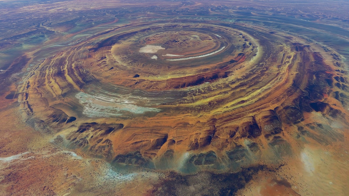
The Richat Structure measures roughly 40 kilometers across, a tight cluster of concentric ridges sitting slightly recessed in the surrounding plateau near the old caravan town of Ouadane, in Mauritania’s remote Adrar region. From above, the rings look like ripples frozen mid-spread. At the center sits a low dome of shattered rock, a chaotic mass called a siliceous megabreccia — stone broken and re-fused, the wreckage of whatever forces lifted this place skyward.
French geographers were the first outsiders to map it, in the 1930s, and they called it the Richat buttonhole — a small, almost domestic word for something that would later be photographed from space. Locals had their own name: Guelb er Richat, with rīšāt meaning feathers in Hassaniya Arabic. They also called it tagense, after the round leather mouth of the pouch used to draw water from a desert well. The people who actually lived beside it saw a well-opening. The astronauts saw an eye. Everyone has always seen the Richat as something other than what it is.
The structure is not, despite its appearance, the result of anything dropping out of the sky. The rings are layers of sedimentary rock — sandstone, limestone, quartzite — laid down over hundreds of millions of years, then bent upward into a dome, then planed flat by erosion. Harder layers resisted the wind and stood up as ridges. Softer layers wore down into the valleys between them. The result is a set of circular cliffs called cuestas, arranged like the contour lines on a topographic map made real. The whole thing is recessed because the inside eroded faster than the rim. That is the entire mechanism. Wind, water, time, and rock of unequal toughness.
It is a textbook of deep geological process, and in October 2022 the International Union of Geological Sciences formally recognized it as one of the first 100 geological heritage sites on Earth. The Eye earned its place in the canon of natural wonders. It did not stay there long. The internet had other plans.
How the Richat Structure Formed: The Crater That Wasn’t
For most of the twentieth century, the answer seemed obvious. A perfect circle 40 kilometers wide in the middle of a desert — what else could it be but the scar of a colossal meteorite?
The impact theory had everything going for it except evidence. Round shape, massive scale, a flat desert canvas with nothing to compete for the eye. It matched the profile of known craters like Arizona’s Barringer or Australia’s Wolfe Creek. Geologists assumed for decades that the Richat was the same kind of wound, just older and bigger.
The problem was the rocks. An impact of the size required to gouge a 40-kilometer hole would leave unmistakable fingerprints — shocked quartz, melted glass, the violent chemistry of stone hit hard enough to flash into a new state. Field teams went looking for that signature. It was not there. The rock layers were not slammed downward and inverted, as an impact would leave them. They were folded gently upward, oldest at the center, exactly as you would expect from something pushed from below rather than struck from above.
The real engine sat underground. Sometime in the Cretaceous, more than 100 million years ago, a mass of molten igneous rock forced its way up beneath the sedimentary layers and shoved them into a broad dome, like a bubble rising through thick syrup. The dome later partly collapsed in on itself. Then erosion took over and spent the next hundred million years doing the patient work of carving the rings we see now. No cosmic violence. Just pressure from beneath and weather from above, working in slow agreement.
The Eye of the Sahara was demoted from a scar of cosmic collision to a masterpiece of erosion. For scientists, that was a more interesting answer, not a lesser one. For the wider world, “deeply eroded magmatic dome” was never going to compete with what came next.
The Atlantis Theory and the Eye of the Sahara
Around 360 BC, the Greek philosopher Plato described a city that has never been found and almost certainly never existed.
In two dialogues, Timaeus and Critias, Plato told of Atlantis: a mighty island empire beyond the Pillars of Hercules, laid out in concentric rings of land and water around a central citadel, rich in metals and elephants, sunk beneath the sea in a single catastrophic day and night around 9,600 BC. Most classicists read Atlantis as exactly what it appears to be — a moral fable, a rhetorical device Plato built to make a point about the corruption of great powers. He was a philosopher inventing a parable, not a historian filing a report. Atlantis was meant to be a lesson, not a place.
The trouble began the moment someone matched a description to a shape.
The Concentric Rings That Launched a Thousand Videos
The Richat Structure has concentric rings. Plato’s Atlantis had concentric rings. For a certain kind of mind, that is not a coincidence. It is a key turning in a lock.
The match, on its surface, is seductive. Plato wrote of alternating rings of land and water around a central island; the Richat presents alternating ridges and valleys around a central dome. Plato gave Atlantis a diameter; a portion of the Richat lands in the same ballpark. Plato said Atlantis sat beyond the Pillars of Hercules — the Strait of Gibraltar — and the Richat sits to the southwest, in roughly the right direction. Plato’s city drowned; the Sahara, the argument goes, was once green and wet, threaded with lakes and rivers before it dried into sand. Lay those points side by side and a pattern seems to assemble itself, ring by ring.
It is the same instinct that made astronauts see an eye and made the meteorite theory feel inevitable. The Richat is built, by pure accident, in the shape of something we are primed to recognize. Plato handed the world a circular city. The Sahara held up a circular ruin. The human brain did the rest.
How a Fringe Claim Became a Mainstream Obsession
In September 2018, a YouTuber published a video, and the Eye of the Sahara stopped belonging to geologists.
The channel was Bright Insight, run by a host named Jimmy, and the video laid out the case that the Richat Structure was Atlantis — not a metaphor for it, not an inspiration, but the literal drowned city Plato described. The presentation was confident and tightly edited. It cited the concentric rings, the matching diameter, a waterway outlet on the southern edge, salty groundwater everywhere except beneath the center, mountains to the north. It tied the destruction date to the Younger Dryas, a real period of climate chaos around 12,000 years ago. It mapped Plato’s measurements onto satellite imagery and let the overlay do the persuading.
It worked. The video drew half a million views within days and climbed past 3.7 million within months. Tabloids on three continents ran with it — British papers, Australian outlets, German and Vietnamese press picking up the African Atlantis. The theory jumped from a YouTube channel into the bloodstream of mainstream curiosity, the way a good story does when it gives people permission to believe something wonderful. Within a year, “Eye of the Sahara Atlantis” was a search term that millions typed in earnest.
The appeal was never really about Plato. It was about the same thing that has always drawn people to the Richat: the refusal to accept that something this perfect could be an accident. A drowned civilization is a more satisfying author than erosion. It gives the rings a maker. It gives the desert a secret. It turns a geology lesson into a treasure map. The same hunger sends people to the Nazca Lines, where vast figures scratched into the Peruvian desert get read as runways for visitors who never came.
Why Archaeologists Say the Eye of the Sahara Is Not Atlantis
The case collapses on contact with the ground itself.
Archaeologist Sean Rafferty has pointed out the obvious structural problem: beyond superficially being circular, the Richat matches almost nothing in Plato’s account. It is a geologically ancient natural formation sitting far inland in a desert — and Plato’s Atlantis was an island, surrounded by ocean, sunk into the sea. A landlocked dome on a high plateau is close to the opposite of a drowned maritime empire. The skeptic Steven Novella catalogued the smaller failures: two concentric rings are not unusual enough to mean anything, the Richat’s rings are broken and incomplete in places rather than the clean nested circles Plato described, and there is no trace of the central canal Plato said connected them all. Count carefully and the structure has the wrong number of rings.
The fatal absence is simpler than any of that. There is no city. A metropolis the size Plato described, home to a metal-working naval empire, would leave debris no flood could fully erase — foundations, walls, ceramics, metalwork, roads, graves, the dense rubble of habitation. The Richat has produced none of it. No buildings. No human remains. No layer in the soil that says people lived here in numbers, at the time the theory requires. The Eye of the Sahara has been studied, mapped, and walked across, and it has yielded the one thing a lost city cannot afford to lack: nothing.
What the desert holds instead is older and, in its own way, more haunting than Atlantis.
Life at the Eye: Stone Tools and the Green Sahara
People did live at the Richat. They simply lived there a very long time before Plato was born — and they left behind something far more real than a myth.
The Acheulean Tools Scattered Across the Eye of the Sahara
Walk the ground inside the rings and you can find stone tools lying in the open, shaped by hands that have been dust for hundreds of thousands of years.
The Richat is littered with Acheulean artifacts — hand axes and worked flint from one of the oldest toolmaking traditions known, a craft that predates our own species. These are not the relics of a single lost city. They are the scattered evidence of an immense human and pre-human presence, deposited across a span of time so vast it makes Plato’s 11,600 years look recent. Someone knelt on this plateau, struck a core of stone with another stone, knapped an edge sharp enough to butcher an animal, and moved on. They did this for an unfathomable stretch of generations. The Eye of the Sahara did not need an advanced civilization to make it remarkable. It already had the deep, anonymous tide of human beginnings washing across it.
The irony is sharp enough to cut. The Atlantis theory asks the Richat to hold the ruins of a fictional super-city 11,600 years old, and rejects the dome’s natural origin as too dull to believe. Meanwhile the actual ground holds the toolkit of real people far older than that, hiding in plain sight, ignored because flint hand axes do not trend on YouTube. The genuine human story of this place is more astonishing than the invented one. It just refuses to flatter us.
The Green Sahara the Desert Erased
The Sahara was not always sand, and that single fact is the seed of every Atlantis dream.
For long stretches over the last ten thousand years and earlier, North Africa was green — a landscape of lakes, rivers, grassland, and the animals that follow water. Herders moved cattle across what is now bone-dry desert. Rock art elsewhere in the Sahara records the elephants, giraffes, and human figures of that wetter world. The land the Richat sits in was, at times, alive in ways that are almost impossible to picture standing in the heat today. Then the climate turned, the rains retreated, the lakes died, and the desert advanced and swallowed all of it — the same slow burial that left medieval libraries stranded in the sand at Chinguetti, a few hundred kilometers south.
This is the grain of fact the myth grows around. The “drowned” Sahara is real — it was drowned not by ocean but by its own former abundance vanishing. The Atlantis theory takes that genuine, documented transformation and uses it as a plausible-sounding stage for a city that was never there. The Green Sahara is the truth that makes the lie believable. The desert really did erase a world. It just was not a world of metal-walled citadels and elephant-drawn chariots. It was a world of grass and water and the people who followed both, and when it died it left no city behind to find — only the wind, and the rings, and the tools half-buried in the sand.
Visiting the Richat Structure Today
Reaching the Eye of the Sahara is harder than seeing it from orbit, and that is not entirely a joke.
The structure lies deep in the Adrar region of Mauritania, near Ouadane — a town founded in 1487 as a Saharan trading post, now a near-ghostly settlement on the edge of one of the emptiest landscapes on the continent. There are no easy roads to the rings and no infrastructure waiting at the end of them. Visitors generally arrive through the city of Atar, hire a 4x4 and a local driver who knows the desert, and cross open terrain to reach the formation. Some travelers fly in by small aircraft or take a balloon flight specifically to see from above what is impossible to grasp from the ground. This is the same harsh, beautiful country that runs the iron ore train across 700 kilometers of emptiness and lets the Atlantic chew apart the hulls at the Nouadhibou ship graveyard. Mauritania’s security situation has historically made parts of the country difficult and at times inadvisable for foreign travel; anyone going should check current advisories and travel with experienced local guides rather than alone. The Sahara is not a place that forgives improvisation.
The strangest part of standing inside the Richat Structure is how little there is to confirm you have arrived. From the center, the great eye dissolves. The rings flatten into ordinary ridges and shallow valleys, the kind of low desert relief you could mistake for nothing. The bullseye exists only from above, in the photographs taken by satellites and astronauts and balloon passengers — a shape your own eyes, standing in the middle of it, cannot assemble. You have to leave the ground to believe it.
There is a quiet lesson in that, and it is worth sitting with before chasing the legend any further. The Eye of the Sahara is genuinely one of the most extraordinary objects on the planet, the product of forces measured in hundreds of millions of years, recognized by geologists as a wonder of the natural world. It needs no drowned empire to deserve attention. The pull toward Atlantis says less about Mauritania than about us — about how badly we want the patterns we see to have been put there on purpose, by someone, for a reason. Stand in the middle of the rings, where the shape disappears and there is only sand and stone and the enormous silence, and the real mystery is not whether a lost city sleeps beneath your feet. It is why the truth of this place — that no one made it, that time and wind did all of it — feels so much harder to hold than the fairy tale.
Frequently Asked Questions About the Richat Structure
Is the Richat Structure really Atlantis?
No credible evidence supports the claim. The theory rests almost entirely on the fact that both the Richat Structure and Plato’s Atlantis are described as having concentric rings, but the resemblance falls apart on inspection. The Richat is a landlocked geological dome on a high desert plateau, while Plato described Atlantis as an island surrounded by ocean that sank into the sea. No ruins, foundations, artifacts, or human remains of a lost city have ever been found there. Most archaeologists and classicists regard Atlantis as a fictional moral fable Plato invented, not a real place.
How was the Eye of the Sahara formed?
The Richat Structure is a deeply eroded geological dome, not a meteorite crater. More than 100 million years ago, a mass of molten igneous rock pushed up from beneath the surface, bending the overlying sedimentary layers into a broad dome. Over the following ages, wind and water erosion stripped the dome down at different rates — harder rock layers stood up as circular ridges while softer layers wore into valleys between them. The result is the bullseye of concentric rings visible today.
Why can astronauts see the Richat Structure but people on the ground can’t?
The structure is enormous — about 40 kilometers across — but its rings are low and gently sloped, making them nearly indistinguishable from ordinary desert terrain at ground level. The circular pattern only resolves into a clear eye when viewed from a great height. Astronauts on the 1965 Gemini IV mission photographed it and used it as a navigational landmark precisely because it stands out so sharply from orbit while blending into the landscape up close.
Where is the Richat Structure located?
The Richat Structure sits in west-central Mauritania, in the remote Adrar region of the Sahara Desert, near the historic caravan town of Ouadane. Most visitors reach it by traveling through the city of Atar and crossing open desert by 4x4 with a local guide. The area is isolated, with little infrastructure, and travel advisories for the region should be checked before any visit.
What does “Richat” mean and what do locals call it?
Locally the formation is known as Guelb er Richat. In Hassaniya Arabic, rīšāt means feathers. It is also called tagense, after the round leather opening of the pouch traditionally used to draw water from desert wells. French geographers who first mapped it in the 1930s referred to it as the Richat buttonhole, a far more modest name than the Eye of the Sahara it later earned from above.
Have any artifacts been found at the Richat Structure?
Yes, but not the kind Atlantis proponents hope for. The structure is scattered with Acheulean stone tools — hand axes and worked flint from one of the oldest toolmaking traditions known, dating back hundreds of thousands of years and predating modern humans. These genuine artifacts reflect an immensely deep human and pre-human presence in the region during periods when the Sahara was greener. They are far older than the roughly 11,600-year timeframe the Atlantis theory requires, and no trace of a built city has ever been recovered.
The “Eye of Africa” (Richat Dome, Mauritania): An Isolated Cretaceous Alkaline–Hydrothermal Complex — Matton, G. & Jébrak, M., Journal of African Earth Sciences (2014)
Eyeing the Richat Structure — NASA Earth Observatory / NASA Science (2022)
Richat Structure, Mauritania — U.S. Geological Survey (2024)
The First 100 IUGS Geological Heritage Sites — International Union of Geological Sciences (2022)
Timaeus and Critias — Plato, trans. Desmond Lee, Penguin Classics (c. 360 BC)
Could the ‘Eye of the Sahara’ Be the Lost City of Atlantis? — Steven Novella, NeuroLogica (2019)
Atlantis and the Richat Structure: An Archaeological Assessment — Sean M. Rafferty, University at Albany (2019)
Frauds, Myths, and Mysteries: Science and Pseudoscience in Archaeology — Kenneth L. Feder, Oxford University Press (2020)
The Eye of the Sahara: Richat Structure Geology — BBC Sky at Night Magazine (2024)
Abrupt Onset and Termination of the African Humid Period — deMenocal, P. et al., Quaternary Science Reviews (2000)