A Collision of Empires at Slavkov u Brna
The Geopolitical Earthquake
On the rolling, frost-hardened hills of southern Moravia, near the quiet town of Slavkov u Brna in the modern Czech Republic, the geopolitical architecture of Europe was violently dismantled and reconstructed in the span of a single winter day. Here, on December 2, 1805, the armies of three empires collided in what history would immortalize as the Battle of the Three Emperors. It was a day that began in a thick, blinding fog and ended under the crimson glow of a setting sun that illuminated the ruin of the Third Coalition. The engagement was the culmination of a campaign that had seen the French army march from the shores of the English Channel to the heart of Central Europe in a display of logistical velocity never before seen in modern warfare.
The Stakes of December 2nd
On this ground, Emperor Napoleon I of France achieved his tactical zenith, shattering the combined might of Tsar Alexander I’s Russian Empire and Emperor Francis II’s Holy Roman Empire. The victory was so total, and the devastation so complete, that it did not merely decide a campaign; it dissolved the thousand-year-old Holy Roman Empire and established French hegemony across the continent. To walk these fields today is to traverse the physical landscape of a masterclass in military deception, where the terrain itself was weaponized to humiliate the old monarchies of Europe. The battle effectively ended the Third Coalition, leaving Britain alone to face France, and redrew the map of German-speaking Europe, planting the seeds for modern Germany.
The Prelude: The Long March to Moravia
The Ulm Maneuver and the Chase
To understand the slaughter at Austerlitz, one must understand the desperation that preceded it. In the autumn of 1805, Napoleon had executed the "Ulm Maneuver," a sweeping encirclement of the Austrian army in Bavaria that resulted in the capture of General Mack’s entire force without a major pitched battle. However, the victory at Ulm had pulled the Grande Armée deep into Austrian territory, stretching their supply lines to the breaking point. As winter set in, Napoleon found himself in Vienna, but the war was far from won. The remnants of the Austrian forces had linked up with the arriving Russian colossus—an army fresh, eager, and commanded nominally by the cautious veteran General Mikhail Kutuzov, but spiritually led by the young, aggressive Tsar Alexander I.
The Hunter Becomes the Hunted
By late November, the strategic situation for France was deteriorating rapidly. Prussia was threatening to join the Coalition, which would place 200,000 fresh enemies on Napoleon’s northern flank. Archduke Charles of Austria was marching from Italy with another massive army to threaten the French rear. Napoleon could not afford a long winter occupation; he needed a decisive, war-ending victory immediately. He needed the Allies to attack him on ground of his choosing, and he needed them to do it before Prussia mobilized. Thus, the stage was set not for a standard engagement, but for a high-stakes gamble where the Emperor of the French would risk his entire crown on a single throw of the dice.
The Strategic Deception: Luring the Bear and the Eagle
The Fiction of Collapse
The road to Austerlitz was paved with a carefully cultivated illusion of frailty. By late November 1805, Napoleon commanded a force of roughly 73,000 men, a deceptively fragile number compared to the combined bulk of the 85,000 to 90,000 Russian and Austrian troops gathering on the horizon. A lesser commander might have retreated to secure lines, but Napoleon chose to lean into the appearance of impending collapse. He ordered his troops to look bedraggled and fearful. He abandoned the town of Austerlitz and, most critically, the Pratzen Heights—the commanding plateau that dominated the local topography.
The Diplomatic Ruse
This psychological theater was performed with consummate skill. In the days preceding the battle, Napoleon sent his aide, General Savary, to the Allied camp to propose an armistice. Savary was instructed to act nervous and evasive. When the arrogant young Russian aide-de-camp, Prince Dolgorukov, visited the French lines, Napoleon allowed him to see "confusion" and "fear" among the French staff. Dolgorukov returned to Tsar Alexander reporting that the "Corsican upstart" was on the verge of retreat. This confirmed the Tsar’s biases; he dismissed the prudent warnings of General Kutuzov, who sensed a trap. The Allied war council, dominated by the Austrian Chief of Staff Weyrother, drew up a complex plan to crush the "fleeing" French army. They believed Napoleon was trapped, and that a decisive blow against his right flank would cut him off from Vienna and drive his broken forces into the mountains of Bohemia.
The Terrain as Protagonist: The Fog, The Heights, and The Stream
The Topography of the Trap
The geography of the Austerlitz battlefield was not a passive backdrop; it was the primary mechanism of the slaughter. The topography is dominated by the Pratzen Heights (Pratecký kopec), a broad, undulating plateau that runs roughly north-to-south and commands the center of the field. By abandoning this key position, Napoleon allowed the Allies to occupy the high ground, further cementing their belief that the French were retreating.
To the west of the heights lay the Goldbach valley, a depression containing the villages of Telnice and Sokolnice, bordered by the Goldbach stream. The stream itself was not a mighty river, but in the freezing December mud, its banks were marshy and difficult to cross for artillery and cavalry. To the south, the freezing waters of the Satschan and Menitz ponds formed a natural barrier, a cold anvil against which the French hoped to crush the enemy.
The Fog of War
Atmospherics played a role as significant as the terrain. On the night of December 1st, a thick fog descended upon the region. On the morning of the battle, this dense, heavy mist settled into the valleys, shrouding the lower ground in an opaque white veil. This fog was Napoleon’s greatest ally. While the Allied troops on the Pratzen Heights enjoyed a clear view of the upper elevations and the "retreating" French fires, the French IV Corps, commanded by Marshal Soult, lay concealed in the valley bottom of the Kobylnitz stream, completely invisible to the enemy observers above. The Allies looked down and saw only the weak French right wing clinging to the villages along the Goldbach, apparently ripe for destruction. They could not see the steel trap waiting in the mist at the foot of the plateau, coiled and ready to strike at the center of their line.
The Battle of the South: The Anvil of the Iron Marshal
The Allied Offensive Begins
The battle opened at roughly 7:00 AM on the French right (southern) flank, just as Napoleon had predicted. The Allied plan, drafted by Weyrother, called for a massive "left hook." Four of the five Allied columns—nearly 40,000 men—were ordered to descend from the Pratzen Heights, storm the villages of Telnice and Sokolnice, and turn the French right.
The fighting in these villages was savage, confused, and desperate. The French defense initially relied on Legrand’s division, a thin line of infantry that was quickly overwhelmed by the sheer weight of the Russian advance. Telnice fell, then was retaken, then fell again. The French were pushed back house by house, fighting in the orchards and the freezing mud of the Goldbach banks.
The Arrival of Davout
Just as the French line seemed poised to break, the strategic depth of Napoleon’s plan revealed itself. The French III Corps, under the command of Marshal Louis-Nicolas Davout—the "Iron Marshal"—arrived on the field. Davout’s men had performed a superhuman feat of endurance, force-marching seventy miles (110 km) from Vienna in just forty-eight hours. Exhausted but disciplined, Davout’s brigades, specifically the Friant Division, threw themselves directly into the fray at Telnice and Sokolnice.
The arrival of III Corps stabilized the line. The fighting in the south devolved into a brutal stalemate of attrition. The Allies, seeing the French resistance stiffen, committed more and more of their reserves from the Pratzen Heights into the valley, obsessed with breaking the right flank. They were feeding thousands of men into the "anvil," unaware that they were stripping their own center bare to do so.
The Lion’s Leap: The Strike at the Center
"One Sharp Blow"
At approximately 8:00 AM, the moment of decision arrived. Napoleon, watching from his command post on Zhuráň Hill, saw that the Allied center on the Pratzen Heights was significantly thinned. The sun began to burn through the mist—the legendary "Sun of Austerlitz"—and the Emperor turned to Marshal Soult. "How long will it take you to move your divisions to the top of the Pratzen Heights?" he asked. Soult replied, "Less than twenty minutes, Sire." Napoleon waited a moment longer, then gave the order: "Very well. You will wait another quarter of an hour and then finish this war with one sharp blow."
The Ascent of Saint-Hilaire and Vandamme
At 9:00 AM, the order was given. In a maneuver that would come to be known as the "Lion’s Leap," the divisions of Generals Saint-Hilaire and Vandamme emerged from the dissipating fog and began their ascent of the Pratzen Heights. The psychological shock was profound. The Allied commanders, including General Kutusov who was still on the heights, were stunned to see waves of blue uniforms surging up the slopes they believed to be empty.
The fighting for the crest of the Pratzen was intense. The Russian regiments that remained—many of them inexperienced or exhausted—fought bravely, launching desperate bayonet charges to throw the French back. But the French infantry, drilled to perfection and buoyed by the surprise, fired devastating volleys that shattered the Russian formations. By 11:00 AM, the French were masters of the heights. The Allied army was effectively cut in two.
The Clash of Giants: The Battle of the Imperial Guards
The Russian Grand Duke's Counterattack
The battle was not yet won. Realizing the disaster unfolding in the center, Grand Duke Constantine, commanding the Russian Imperial Guard, launched a furious counterattack to retake the Pratzen Heights. This was the elite of the Russian military—the Preobrazhensky and Semenovsky regiments, giants of men loyal to the Tsar. They crashed into the French division of Vandamme, breaking the first line and capturing a French Eagle standard—a deep humiliation for the Grande Armée.
Napoleon Plays His Final Card
Witnessing his line waver, Napoleon committed his own reserves: the Cavalry of the Imperial Guard, led by Marshal Bessières. The resulting clash was one of the most famous cavalry engagements of the Napoleonic Wars. The French Mamelukes, Grenadiers à Cheval, and Chasseurs à Cheval collided with the Russian Horse Guards in a swirling melee of sabers and lances atop the plateau. The painting by Gérard famously depicts this moment, but the reality was a gruesome, close-quarters slaughter.
The French Guard prevailed. The Russian Guard was broken and driven back. With the failure of this last desperate counterattack, the Allied center ceased to exist.
The Northern Flank: Lannes vs. Bagration
The Duel on the Santon
While the drama unfolded in the center and south, a separate, equally intense battle was raging on the northern flank along the Olomouc road. Here, Marshal Jean Lannes, arguably Napoleon’s most talented subordinate, faced Prince Bagration, the most capable of the Russian generals.
This sector was anchored by the Santon Hill, a small prominence that Napoleon had ordered fortified with trenches and an 18-gun battery. Bagration attempted to flank the French left, but Lannes, supported by Murat’s cavalry, executed a disciplined, flexible defense. Once the center had collapsed, Lannes switched to the offensive, pushing Bagration back methodically. Unlike the rout in the south, the retreat in the north was orderly, largely due to Bagration’s skill, but it removed the northern pincer from the equation, allowing Napoleon to focus entirely on annihilating the Allied left.
The Destruction of the Allied Left
The Pivot South
By early afternoon, the situation for the Allies was catastrophic. With the Pratzen Heights secured and the Russian Guard defeated, Napoleon ordered Soult’s corps to pivot ninety degrees to the south. They were no longer attacking; they were acting as a door closing on the trap.
Soult’s men marched down from the heights into the rear of the Allied columns that were still locked in combat with Davout in the Goldbach valley. The Allied troops, pinched between Davout’s immovable defense and Soult’s crushing advance, were thrown into a chaotic panic. Command and control disintegrated completely.
The Myth and Reality of the Satschan Ponds
As the Allied left wing collapsed, thousands of fleeing Russian and Austrian troops were driven toward the only escape route remaining: the frozen expanses of the Satschan and Menitz ponds. This phase has been mythologized in art and literature, most notably by Leo Tolstoy in War and Peace, who depicted French artillery smashing the ice and drowning tens of thousands of men in the freezing water.
The reality, revealed by modern archaeology and historical inquiry, is less apocalyptic but no less grim. Napoleon did order his artillery to fire on the ice to cut off the retreat. However, when the ponds were drained and excavated days after the battle (and again in modern times), the number of drowned soldiers recovered was in the dozens or low hundreds, not thousands. Most of the "drowning" casualties were actually men trapped in the marshy mud of the littoral zones or those who succumbed to hypothermia. Yet, even without the exaggerated death toll of the ponds, the devastation was absolute. The Allied army lost over 27,000 men (killed, wounded, and captured) and 180 guns. The French losses were roughly 9,000.
The Aftermath: A Red Sun Sets on the Holy Roman Empire
The Treaty of Pressburg
The guns fell silent as the winter night descended, but the political reverberations of Austerlitz would shake the foundations of Europe for a decade. The immediate consequence was the Treaty of Pressburg, signed on December 26, 1805. Austria was forced to withdraw from the war and cede vast swathes of territory: Venetia was given to the Kingdom of Italy, while Tyrol and Vorarlberg were ceded to Bavaria. Austria lost 4 million subjects and was reduced to a second-rate power.
The End of the Reich
More profoundly, the defeat compelled Francis II to abdicate his title as Holy Roman Emperor in August 1806, formally ending the Holy Roman Empire of the German Nation—an institution that had stood since the coronation of Charlemagne in 800 AD. In its place, Napoleon created the Confederation of the Rhine, a collection of German client states that served as a buffer for France. The Russian army limped back to the east, beaten and humiliated, Alexander’s dreams of martial glory shattered. Napoleon was now the undisputed master of Europe, his reputation as a military genius cemented into a legend that would terrify his adversaries until Waterloo.
The Modern Site: Walking the Fields of Slavkov
The Landscape of Memory
Today, the battlefield of Austerlitz remains remarkably preserved, an open landscape of agrarian fields that allows the modern visitor to read the terrain much as the commanders did in 1805. Unlike Waterloo, which has been encroached upon by suburban development, the rolling hills of Moravia remain quiet, agricultural, and stark.
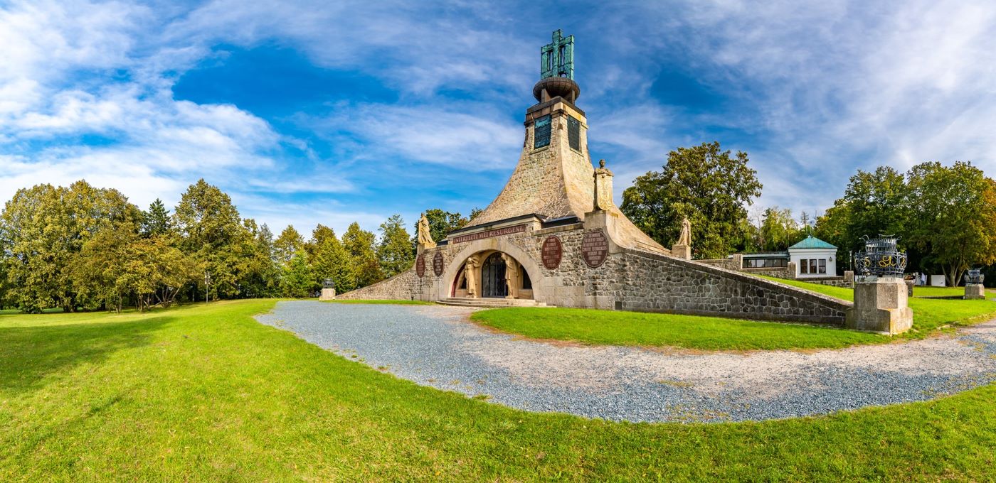
The Mohyla míru (Cairn of Peace)
The centerpiece of the site is the Mohyla míru, or Cairn of Peace, located on the pivotal Pratzen Heights. Constructed between 1910 and 1912, this Art Nouveau monument is distinct in its purpose: it honors the dead of all nations, rather than celebrating the victor. It takes the form of a quadrilateral pyramid, over 26 meters high, topped with a brass cross. Inside, a chapel with extraordinary acoustics offers a space for reflection, while an underground ossuary holds the remains of soldiers recovered from the fields. Adjacent to the monument, a modern multimedia museum provides a rigorous breakdown of the campaign, featuring artifacts recovered from the soil—rusted bayonets, shako plates, and the personal effects of men who died for empires that no longer exist.
Zhuráň and Santon Hills
To the north lies Zhuráň Hill, the command post where Napoleon stood to oversee the opening phases of the battle. A small granite map atop the hill orients the visitor, allowing one to gaze down into the mist-prone valley where the deception was orchestrated. It was here that Napoleon famously slept in his carriage the night before the battle.
Further north, near the Brno-Olomouc road, is Santon Hill, a small prominence that anchored the French left flank. Fortified with trenches and artillery in 1805, it remains a distinct landmark, crowned by a small white classicist chapel (Chapel of the Virgin Mary of the Snows). The chapel was there during the battle; the French unroofed it to use the walls as embrasures, but it survived the cannonade and remains a poignant symbol of the local population’s endurance.
The Old Post Office at Pozořice
Another key site is the Old Post Office (Stará Pošta) in Pozořice. This historic building served as Murat’s headquarters and, following the battle, was the site where Napoleon met with the Austrian emissary Prince Liechtenstein to discuss the ceasefire. It now houses a museum focusing on the cavalry engagements and the diplomatic aftermath.
Pilgrimage to the Battlefield: Logistics and Access
The Approach from Brno
Visiting Austerlitz requires a deliberate journey, best undertaken from the nearby city of Brno, the second-largest city in the Czech Republic, which serves as the logistical gateway to the region. The battlefield is not a single compact park but a sprawling landscape covering several square kilometers of active farmland and villages. While public buses run from Brno to the town of Slavkov u Brna (where the spectacular baroque castle that hosted the armistice negotiations stands), fully appreciating the tactical nuance of the field requires a car or a specialized guide.
Navigating the Landscape
The drive from Brno takes approximately twenty minutes, leading the traveler out of the urban sprawl and into the undulating countryside. The sites are widely spaced; the distance between the Goldbach valley and the Pratzen Heights is roughly 4-5 kilometers. For the historical pilgrim, the recommended route is chronologically driven:
- Start at Zhuráň Hill: Survey the panorama and understand the French starting position.
- Descend to Telnice/Sokolnice: Visit the villages to see the "anvil" where Davout held the line.
- Ascend the Pratzen Heights: Drive up to the Cairn of Peace to stand where the Russian center collapsed.
- End at Slavkov Castle: Visit the town of Slavkov u Brna to see the famous balcony where Napoleon addressed his troops and the hall where the armistice was signed.
The Coda: Echoes Across the Moravian Plain
A Silence Heavy with History
Ultimately, Austerlitz is more than a tactical diagram etched into the earth; it is a graveyard of empires. As the sun sets over the Pratzen Heights today, casting long shadows across the wheat fields that once drank the blood of 30,000 men, the silence is profound. The land remains much as it was when the "Sun of Austerlitz" rose to herald the zenith of the Napoleonic era. It stands as a permanent, physical testament to the day when the old world died in the mud, and a new, terrible modernity was born in the fire of French cannon. To stand on the heights is to feel the weight of that history—the ambition of the Eagle, the hubris of the Bear, and the tragic twilight of the Holy Roman Empire.
Frequently Asked Questions (FAQ)
1. Where is the Austerlitz battlefield located today?
The battlefield is located in the Czech Republic (Czechia), approximately 20 kilometers (12 miles) east of Brno in the region of Moravia. The area centers around the town of Slavkov u Brna (historically Austerlitz). It is easily accessible by car or public bus from Brno. The site is not a single enclosed museum but a protected landscape zone covering several villages and fields that appear much as they did in 1805.
2. Can you visit the Pratzen Heights?
Yes, the Pratzen Heights (Pracký kopec) is the centerpiece of the battlefield visit. The hill is dominated by the Mohyla míru (Cairn of Peace) memorial and a modern museum annex that offers an excellent multimedia interpretation of the battle. Visitors can walk the plateau where the decisive clash occurred. It functions as an open-air museum, and access to the grounds is free, though the museum interior requires a ticket.
3. Is the story about thousands drowning in the frozen lakes true?
This is largely a myth propagated by Napoleon’s own 30th Bulletin of the Grande Armée. While French artillery did fire on the ice to cut off the Russian retreat across the Satschan and Menitz ponds, archaeological excavations have debunked the claim of catastrophic drowning. When the lakes were drained shortly after the battle, only a few dozen cannons, about 180 horses, and very few human bodies were recovered, not the thousands often depicted in art.
4. When does the annual Austerlitz reenactment take place?
The commemorative events take place annually on the weekend closest to December 2nd (the anniversary of the battle). The main event is a large-scale reenactment usually held near the village of Tvarožná (under the Santon Hill), featuring thousands of uniformed participants from across Europe, cavalry, and artillery. Smaller ceremonies and a pious act of remembrance also occur at the Cairn of Peace on the Pratzen Heights during the same weekend.
5. How much time should I budget for a visit?
To fully appreciate the scale of the battlefield, budget at least half a day (4–5 hours). A recommended itinerary includes starting at the Cairn of Peace and museum on the Pratzen Heights (1.5 hours), driving to the Santon Hill (30 mins), and finishing at Slavkov Castle in the town of Slavkov u Brna (1–2 hours). If you plan to hike the yellow tourist trails between villages, allow for a full day.
Sources & References
Books & Academic Texts:
- Chandler, David G. The Campaigns of Napoleon. Scribner, 1966. (The definitive operational history).
- Duffy, Christopher. Austerlitz 1805. Seeley Service, 1977. (Excellent tactical analysis of the terrain).
- Goetz, Robert. 1805: Austerlitz: Napoleon and the Destruction of the Third Coalition. Greenhill Books, 2005. (The modern revisionist standard, particularly regarding the frozen lakes).
- Castle, Ian. Austerlitz 1805: The Fate of Empires. Osprey Publishing, 2002. (Visual guide to unit movements).
- Markham, Felix. Napoleon. Mentor, 1963. (Biographical context).
- Tolstoy, Leo. War and Peace. (Specifically Books 3 and 4 for the literary/cultural impact of the battle).
Live Digital Resources:
- Project Austerlitz (Austerlitz.org): The official portal for the annual commemorations and historical data.
- Slavkov Castle (Zámek Slavkov): Official visitor site for the chateau and armistice history.
- Muzeum Brněnska (Museum of the Brno Region): Curators of the Cairn of Peace Memorial.
- Napoleon.org: The Foundation Napoleon’s extensive archive of bulletins and correspondence from 1805.