The Descent Ritual That Made the Yungas Road the World's Most Dangerous
A driver coming down the old Yungas Road keeps his door open and his head out the window. He has to. The road is barely three meters wide in places, the rock wall scrapes his left mirror, and the only way to know where his right wheels are is to look. So he leans into the wind, eyes locked on the strip of mud between his tire and the lip, where the mountain simply ends and 600 meters of wet air begins. His passenger leans out the other side and calls the gap. A hand-width. Half a hand-width. The cloud is so thick that neither of them can see the river at the bottom of the gorge. They can only feel the truck tilt as the outer tires find the soft edge.
This is not recklessness. This is the rule. On the entire length of the road, vehicles drive on the left — the opposite of the rest of Bolivia — for one cold-blooded reason: it puts the descending driver on the cliff side, where he can judge his own margin instead of trusting the man coming up. Descending traffic has no right of way and must yield to the outer edge. The country rewrote the physics of how its citizens drive because the alternative was worse.
The North Yungas Road was built to connect a landlocked, mountain-locked country to the green lowlands it could not reach. It became the most efficient way that country had ever invented to kill its own people. Coca farmers, soldiers, schoolchildren, market women with crates of fruit lashed to the roof — for seventy years they went over the side in trucks and buses by the hundreds, year after year, until the road earned a name no one disputes. El Camino de la Muerte. The Death Road. The cruelest part is what came after: once the killing slowed, the tourists arrived precisely because of it.
How Bolivia Lost a War and Carved a Road Into the Cliff by Hand
Bolivia in the 1930s was a country that had just lost almost everything. The Chaco War against Paraguay, fought from 1932 to 1935 over a barren scrubland the size of a small nation, cost Bolivia roughly 60,000 dead and a humiliating defeat. The country emerged broke, broken, and acutely aware of a strategic weakness it could no longer ignore: its capital, La Paz, sat trapped on the high altiplano at nearly 3,600 meters, cut off from the fertile Yungas valleys and the Amazon lowlands by a wall of mountains.
A road would fix that. The government decided to drive one straight down the eastern face of the Cordillera Oriental, through cloud forest and across near-vertical slopes, linking the cold city above to the warm coca country below. There was no money for machines and no machines for the terrain. So the labor came from the war that had just ended.
The Chaco War Prisoners Who Built the Death Road
Paraguayan prisoners of war carved the road out of the mountain with picks, shovels, and dynamite. Bolivia held thousands of captured soldiers after the Chaco War, and many were put to work cutting a ledge into a cliff that engineers with modern equipment would hesitate to touch today. They worked in constant rain, in fog that erased the edge of the world, on slopes where a single loosened section of earth could carry a man off the mountain. Men died building it. The exact number is not recorded, which is its own kind of answer about how those lives were valued.
The road that resulted was less a road than a scar — a shelf of dirt and rock pinned to the side of a gorge, three meters wide where it was generous, slick the moment it rained, and open on one side to a fall that nothing survived. The men who cut it were prisoners of a war over empty land, building a passage they would never use, in a country that was not theirs. Local legend later held that the road's appetite for the dead was their revenge. It is a story Bolivians still tell, and it is easy to understand why they need it.
The Impossible Geography of a 3,500-Meter Plunge
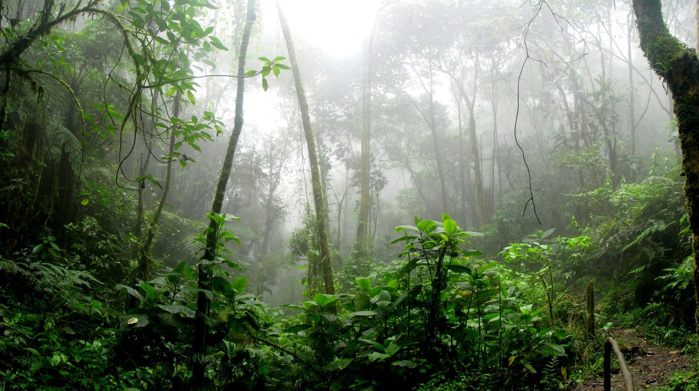
The numbers explain the danger better than any adjective. The road climbs first to La Cumbre pass at roughly 4,650 meters, where the air is thin and the cold cuts, then plunges to around 1,200 meters at the town of Coroico in under 64 kilometers. That is a vertical drop of more than 3,400 meters across the span of a short drive — the altiplano's frozen rock giving way to dripping subtropical jungle in the space of a few hours. The descent passes through cloud forest that hangs in permanent mist. Waterfalls spill directly across the track and chew the surface to mud. The drops beside the road reach 600 meters of unbroken vertical. There are no guardrails. There never were.
Why the Death Road Killed 200 to 300 People Every Year
The Yungas Road did not need malice to kill. It needed only ordinary days. Fog dropped visibility to a few meters without warning. Afternoon rain turned the dirt to grease. Rockfalls and landslides reshaped the track overnight. Two vehicles meeting on a stretch too narrow for both forced one of them to reverse, blind, toward an edge it could not see — and Bolivia's aging fleet of overloaded buses and freight trucks, brakes worn, tires bald, did this several times a day, every day, for decades.
The Left-Hand Rule and the Human Traffic Lights of the Death Road
The inverted left-side driving law was the road's most famous safety measure, and it tells you everything about the level of danger that such a measure was considered helpful. Putting the descending driver on the outside let him gauge his own clearance over the abyss instead of guessing. But the rule could only do so much on a track where two trucks physically could not pass without one of them crawling backward along the precipice.
So men stood at the worst bends and did the job no sign could do. Locals called them the human traffic lights — figures posted at blind curves to watch for oncoming vehicles and wave drivers through one at a time, hour after hour, in the rain and the fog, on the edge of a 600-meter fall. Some took the work after the road had already taken their families. The road did not pay them. The drivers did, in coins, for the chance to round a corner without dying.
The 1995 Verdict and the Crosses That Line the Road
The Inter-American Development Bank made the title official in 1995, when a report named the North Yungas Road the most dangerous road in the world. By then the estimate of 200 to 300 deaths a year had hardened into accepted fact, and the evidence stood along the entire route in plain sight. White crosses marked the bends where buses had gone over. Rusting hulks of trucks lay far below, too deep in the gorge to recover, slowly vanishing into the green. In one stretch in the mid-1990s, witnesses counted twenty-six vehicles going off the edge in a span of weeks — roughly one every two weeks, a rate of attrition that would close any road in a wealthier country and simply became routine here.
The Death Road's body count put it in grim company with Bolivia's other great engines of death. At Potosí, a silver mountain four centuries earlier had swallowed an estimated eight million lives to fill Spanish treasuries; the Yungas Road swallowed its hundreds a year to move coca and freight. Both were infrastructure. Both ran on the understanding that the people feeding them were replaceable.
The Devil's Curve Disaster and the Deadliest Crash in Bolivian History
On July 24, 1983, an overloaded bus came down the Yungas Road and lost control on a turn the locals called the Curva del Diablo — the Devil's Curve. It went over the edge into the ravine below. More than a hundred passengers were aboard. None of them survived. It remains the worst road disaster in the history of Bolivia.
There is no roll call of who they were, because they were ordinary — the kind of people who filled the buses every day, packed into the aisle, riding down to the Yungas to sell, to work, to go home. The bus that carried them was the everyday machine of the road: too full, too heavy, too worn, taking a curve it had taken a thousand times. A memorial of crosses marks the spot now. It is one cluster among many along the route, distinguished only by the number of the dead.
A Road Used to Murder the Regime's Enemies
The Death Road did not kill only by accident. In November 1944, the government of President Gualberto Villarroel — himself a Chaco War veteran — crushed a conspiracy against his rule and chose to execute the plotters without trial. Several of the condemned were driven up the Yungas Road to a sheer-cut place called Chuspipata. There the senators Luis Calvo and Félix Capriles, the former ministers Carlos Salinas Aramayo and Rubén Terrazas, and General Demetrio Ramos were shot and their bodies thrown off the cliff into the gorge.
The choice of location was not random. The road that killed by carelessness could be made to kill on command, and the same drop that erased a busload of farmers could erase the regime's enemies just as cleanly. The bodies were found below. The brutality of it horrified Bolivia's cities and began the unraveling of Villarroel's government, which ended two years later when a mob dragged the president from the palace and hanged him from a lamppost in the plaza. A plaque on the road now marks the Chuspipata killings as a milestone in the country's democratic struggle. The cliff that received the dead has, in the Bolivian memory, become a monument.
From Death Road to Adrenaline Pilgrimage
The killing did not stop because the road got safer. It stopped because, after twenty years of construction, the traffic finally went somewhere else.
The 2006 Bypass That Emptied the Cliff
A modern alternative route, wider and paved, with two lanes and guardrails, opened to traffic in 2006 after roughly two decades of work. It connected La Paz to Coroico without the cliff, the fog, or the human traffic lights, and almost overnight the great mass of buses and freight trucks abandoned the old road. The annual death toll collapsed. The most dangerous road in the world became, for long stretches of the day, one of the quietest — a near-empty shelf of dirt where the loudest sound was water falling across the track.
The Mountain Bikers Who Keep Dying on the Death Road
The bicycles had already arrived. From the late 1990s, tour operators in La Paz had begun running thrill-seekers down the descent — 3,500 vertical meters of gravity, from the cold of La Cumbre to the heat of the jungle, on the road famous for killing. The bypass turned a trickle into a flood. Today around 25,000 cyclists a year ride the Death Road, kitted with helmets, full-suspension bikes, and guides who brief them at the top about the edge.
The edge does not care about the briefing. Cyclists have died here too — going too fast into a curve, losing the wheel in gravel, simply riding off the side the way the buses did. The riders come from all over the world to taste a danger that locals spent seventy years trying to survive, which is a contradiction the road wears openly. The Yungas Road is now a livelihood for Coroico's tour guides in the same way the Mauritania Iron Ore Train became a rite of passage for travelers who ride a brutal industrial corridor for the story of having done it. In both cases, the danger is the product.
The Atlas Entry: Visiting Bolivia's Death Road Today
The descent begins at La Cumbre, where the air is cold enough to numb fingers and the asphalt of the first paved kilometers gives a false sense of ease. The dirt starts where the old road branches off the modern bypass, and from there it is roughly 32 kilometers of single track to the warm air of Coroico. The cloud forest closes in. Waterfalls cross the road. The drop is always on one side, unguarded, and on a clear day you can see straight down to the river. Most riders descend with an operator out of La Paz; the day runs from dawn to early afternoon, and the temperature climbs by tens of degrees from top to bottom. Trucks and local vehicles still use the road, so it is not empty, and the left-hand rule still applies.
The crosses are still there. So are the wrecks in the gorge, rusting where they fell. The road is not a memorial in any official sense — it is a working road, a tourist attraction, a place people earn a living. But to ride it is to descend through a graveyard whose dead were mostly ordinary Bolivians doing ordinary things, on a track cut by prisoners of a forgotten war. The view is genuinely among the most spectacular in South America. That is exactly what made it lethal. The reasonable thing is to ride it with that knowledge held steadily in mind, neither looking away from the drop nor pretending the danger is a game the dead also got to play.
Frequently Asked Questions About Bolivia's Death Road
Why is Bolivia's North Yungas Road called the Death Road?
The North Yungas Road earned the name El Camino de la Muerte because it killed an estimated 200 to 300 people every year for most of the twentieth century. Buses and trucks regularly went over its unguarded edge into drops of up to 600 meters, and in 1995 the Inter-American Development Bank officially declared it the most dangerous road in the world. White crosses and the rusted wrecks of vehicles still mark the bends where people died.
Who built the Death Road in Bolivia?
The road was carved into the Cordillera Oriental in the 1930s, largely by Paraguayan prisoners of war captured during the Chaco War of 1932 to 1935. They cut the route by hand using picks, shovels, and dynamite, working on near-vertical slopes in constant rain and fog. An unknown number died during construction, and Bolivia built the road to connect its capital, La Paz, to the Yungas valleys and the Amazon lowlands after losing the war.
What was the deadliest accident on the Death Road?
The worst disaster occurred on July 24, 1983, when an overloaded bus lost control at a bend known as the Curva del Diablo, or Devil's Curve, and plunged into the ravine below. More than a hundred passengers were aboard, and none survived. It remains the deadliest road accident in Bolivian history.
Why do cars drive on the left side of the Death Road?
The Yungas Road is the one place in Bolivia where vehicles drive on the left instead of the right. The inverted rule places descending drivers on the cliff side, giving them a clear view of their outer wheels relative to the edge so they can judge their margin over the drop. Descending traffic also has no right of way and must yield toward the outer edge to let vehicles pass.
Is it safe to bike down the Death Road today?
A modern bypass road opened in 2006 and diverted most vehicle traffic, dramatically reducing fatalities on the old route. Today around 25,000 tourists a year cycle the descent with guided operators using helmets and proper bikes. The road remains genuinely dangerous, however, and cyclists have died on it since the tourism boom began in the late 1990s, mostly from losing control on curves or gravel.
How long is the Death Road and how much does it descend?
The North Yungas Road runs roughly 64 kilometers between La Paz and Coroico. It climbs to about 4,650 meters at the La Cumbre pass and drops to around 1,200 meters near Coroico, a vertical descent of more than 3,400 meters. In that short span the landscape changes completely, from cold high-altitude rock to humid subtropical cloud forest.
Sources
The Death Road in Bolivia: History, Tragedies and Tourism Rebirth — Chamánica Coroico (2026)
Yungas Road and the 1995 Most Dangerous Road Designation — Inter-American Development Bank (1995)
Gualberto Villarroel and the Chuspipata Executions of November 1944 — Historias de Bolivia (2017)
Los Asesinatos de Chuspipata en 1944 y la Violencia Estatal — Educa Bolivia
The 1946 La Paz Riots and the Fall of Villarroel — Cambridge University Press (2003)
Is This 'Death Road' the Most Dangerous in the World? — Great Big Story (2024)
Death Road — RTÉ Travel (2009)
The Chaco War, 1932–1935 — Bruce W. Farcau, Praeger (1996)
North Yungas Road — Atlas Obscura (2026)
Death Road Bolivia Guide: North Yungas Road History and Cycling — Geography Worlds (2026)