The Chat Piles of Picher: Mountains of Mine Waste That Poisoned a Generation
Children in Picher grew up climbing mountains that had not existed a century earlier. The chat piles — pyramids of crushed grey rock left over after the lead and zinc were milled out of the ore — rose directly behind houses, behind the grocery, behind the school. Some passed 200 feet. Kids rode motorbikes up them, sledded down them on flattened cardboard, and swam in the flooded pits at their feet, where the water sat an unnatural blue-green.
The dust came home with them in their hair and in their lungs. It was lead, cadmium and zinc, ground to the consistency of coarse sand by industrial mills and stacked in the open for eighty years.
Adults hauled the same material home by the pickup load. Chat was free, it drained well, and there was an unlimited supply, so Picher used it for driveways, foundations, road base, the school's grounds and children's sandboxes. The town built itself out of its own waste, then wondered for two generations why so many of its kids struggled to read.
Picher is the sharpest American example of a simple arrangement: the wealth of an extraction economy leaves, and the residue stays. The ore under Ottawa County armed the American infantry in two world wars and made fortunes in Kansas City, St. Louis and New York. What remained in Picher was 75 million tons of tailings, a honeycomb of collapsing tunnels, and a population the federal government would eventually decide it was cheaper to relocate than to protect. Phosphate mining stripped Nauru down to bare coral pinnacles across roughly four-fifths of its surface; Picher achieved a comparable result in a landlocked Oklahoma county by stacking the waste on top of the town instead of hauling it away.
How the Tri-State Mining District Turned Quapaw Land Into a Lead Empire
The 1913 Lead Strike That Built Picher, Oklahoma From Nothing
Lead was found under Ottawa County in 1913 by Harry Crawfish, a Quapaw man prospecting on allotment land in a district that had already been producing ore across the state line in Missouri and Kansas for decades. The strike proved to be the richest in the entire Tri-State Mining District, and the field it opened would become the most productive lead and zinc ground in the world.
The town went up fast and without ceremony. It took its name from O. S. Picher of the Picher Lead Company, incorporated in 1918, and within two years held more than 14,000 people. Mining camps, boarding houses and mills spread across a landscape that had been prairie and Quapaw farmland inside of a decade.
Quapaw Allotments and the Mineral Royalties the Bureau of Indian Affairs Controlled
The ore sat under land the federal government had allotted to members of the Quapaw Nation, and the leases were administered by the Bureau of Indian Affairs. Royalty checks turned a small number of Quapaw allottees into wealthy people almost overnight, on paper. The same guardianship machinery that handled Osage oil money in the county next door handled Quapaw mineral money here — court-appointed guardians controlling the accounts of adults declared incompetent to manage their own wealth, with the predictable outcomes.
The arrangement had a long tail. The Quapaw were made briefly rich by ore they did not mine, on land they could not lease on their own terms, and were left a century later holding the most contaminated forty square miles in the United States. The tribe is still involved in the cleanup of ground its own allotments once made profitable.
Picher's Boom Years: 20,000 People Living Above 300 Miles of Mine Tunnels
Mining Picher's Lead and Zinc: The Work That Fed Two World Wars
Picher's ore went into ammunition. The Tri-State district supplied roughly half the lead and a comparable share of the zinc used by American forces in the First World War, and the field ran hard again through the Second. Every rifle cartridge, every artillery shell, every brass casing drew on a supply chain that started in a shaft under an Oklahoma street.
The scale underground is difficult to hold in the head. Miners drove more than 300 miles of tunnels beneath Picher and its neighbouring towns, sinking thousands of shafts, hollowing out chambers with roof spans wide enough to lose a house in. The town on the surface was a thin crust over an inverted city.
Miner's Con: Silicosis, Tuberculosis and the Short Lives of Picher's Underground Workers
Men in the Picher field died of their lungs long before anyone worried about the children. Dry drilling into chert-rich rock threw off silica dust in enclosed spaces with poor ventilation, and the result was silicosis — known locally and flatly as miner's con. Scarred lungs took tuberculosis readily, and Ottawa County carried tuberculosis rates that stood out even against the grim national numbers of the 1920s.
The industry response was slow and grudging. Wet drilling, which suppresses the dust, was understood as a control decades before it became standard practice in the field, and companies resisted the expense while a generation of men in their thirties and forties coughed themselves to death in company housing.
Mickey Mantle, Commerce, and the Mining Families of Ottawa County
The most famous product of this ground was a baseball player. Mickey Mantle grew up in Commerce, four miles down the road from Picher, in a family that lived off the mines. His father, Elvin "Mutt" Mantle, worked lead underground and pitched a ball to his son in the yard after shifts, drilling him left-handed and right-handed until the boy could switch-hit.
Mickey went into the mines himself as a teenager, briefly, hauling ore. Mutt Mantle died in 1952 at 39, of Hodgkin's disease. His son played in the World Series that October.
The Mantles were unremarkable in Ottawa County. That was the arrangement across the whole field — the father in the shaft, the mother in a company house downwind of the mill, the children on the chat pile because there was nowhere else to play.
The Collapse: Why Picher's Mines Closed and the Ground Began to Give Way
Cave-Ins, Sinkholes and the Streets That Opened Beneath Picher
The mines ran out of profit before they ran out of ore. Cheaper foreign lead and zinc and falling post-war demand closed operation after operation through the 1950s and 1960s, and by 1970 commercial mining in the Picher field was finished. The companies left the workings where they were. Resource towns die this way routinely — Uranium City in northern Saskatchewan lost four-fifths of its population within two years of its mine closing in 1982 — and the usual ending is a slow emptying. Picher stayed full, because the people who lived there had houses they could not sell and jobs an hour's drive away.
Abandoned mine workings deteriorate the moment maintenance stops. Pillars left to hold up roofs are cut to the minimum a company needs during operation, and once nobody is watching them they weather, crack and fail. Ground began opening in Picher — in yards, under roads, beside foundations. Residents learned to recognise the signs and, in the way of people who cannot move, learned to live with them.
Abandoned Mines, Rising Water, and the Orange Flood of Tar Creek in 1979
Pumps had kept the mines dry for sixty years. When the last of them stopped, water rose through 300 miles of tunnel, dissolving iron, lead, cadmium and zinc out of the exposed rock as it went.
In 1979 it reached the surface. Acid mine drainage pushed up through abandoned boreholes and shafts and ran into Tar Creek, and the creek turned orange — a hard rust colour from iron oxide, visible from the road, staining the bed and the banks and the rocks for miles downstream. The problem that had been invisible for a decade came up out of the ground and announced itself.
Tar Creek Superfund Site: One of the First and Worst on the EPA's National Priorities List
1983: How Tar Creek Landed on the EPA's Original Superfund List
The Environmental Protection Agency placed Tar Creek on its first National Priorities List in 1983, among the very first sites designated when the Superfund programme began. The listed area covers roughly forty square miles of Ottawa County and ranks among the most contaminated ground in the country by almost any measure applied to it.
Early work focused on the water. Engineers plugged boreholes and built diversion structures to keep surface water out of the mine workings, on the theory that reducing inflow would reduce the acid discharge. The creek stayed orange.
Lead Poisoning in Picher's Children: The Blood Tests That Changed Everything
Blood testing in the 1990s produced the number that ended the argument. Screenings of Picher-area children found roughly one in three carrying blood lead levels above the federal threshold of concern — a rate many times the national average, in a town of a few thousand people.
Lead does specific things to a developing brain. It lowers IQ, damages attention and impulse control, and the damage does not reverse when exposure stops. Teachers in Picher had been reporting unusually high rates of learning difficulty for years before anyone connected it to the grey dust on the playground.
The exposure route was mundane. Children breathed chat dust, swallowed it off their hands, tracked it into carpets, and drank water and ate garden vegetables grown in soil that carried it. The town was inside the contaminant rather than next to it.
Chat in the Sandbox: How Mine Waste Ended Up in Driveways, Schools and Playgrounds
Chat had a long second life as free construction aggregate, and that is what carried the lead into every corner of daily life in the region. Mine tailings went into road base, railroad ballast, concrete, asphalt and parking lots across northeast Oklahoma and beyond. Homeowners spread it on driveways. Parents shovelled it into sandboxes because it was clean-looking, well-drained and cost nothing.
The EPA eventually dug up and replaced the soil in thousands of residential yards across the district. Crews worked street by street, scraping contaminated ground off properties and hauling in clean fill, while the source of the contamination stood in 200-foot piles a few hundred yards away.
The Buyout: How the U.S. Government Decided Picher Should Not Exist
The 2006 Army Corps Study That Found Most of Picher Undermined
Subsidence closed the file that poisoning had opened. The U.S. Army Corps of Engineers surveyed the ground under Picher and Cardin and reported in 2006 that the overwhelming majority of the towns' structures — 86 percent — stood over mine workings at risk of collapse, and that no engineering fix existed at any price the country would pay.
That finding changed the question. Contamination is something a government argues about remediating for decades, and Tar Creek had already absorbed twenty-three years of that argument. Ground that may swallow a school is something a government has to answer for immediately.
Paid to Leave: The Federal Relocation of Picher's Residents
Oklahoma had already begun moving families with young children out of the worst-affected areas through a state relocation trust established in 2004. The federal buyout that followed in 2006 extended the offer to everyone: a voluntary purchase of homes and businesses at pre-contamination value, funded through Congress at the urging of Senator Jim Inhofe, on the understanding that the towns would be closed.
Most people took it. A minority did not, and their reasons were the reasons people always give — a house built by a grandfather, a business with a mortgage, a cemetery plot, the plain refusal to be told where to live by a survey. Appraisers walked streets where half the houses were already gone and the other half had people still cooking dinner in them. Demolition crews followed. Picher spent two years being taken apart around the residents who stayed.
The 2008 Picher Tornado: The EF4 That Finished a Town Already Being Dismantled
Eight Dead and 150 Homes Destroyed on May 10, 2008
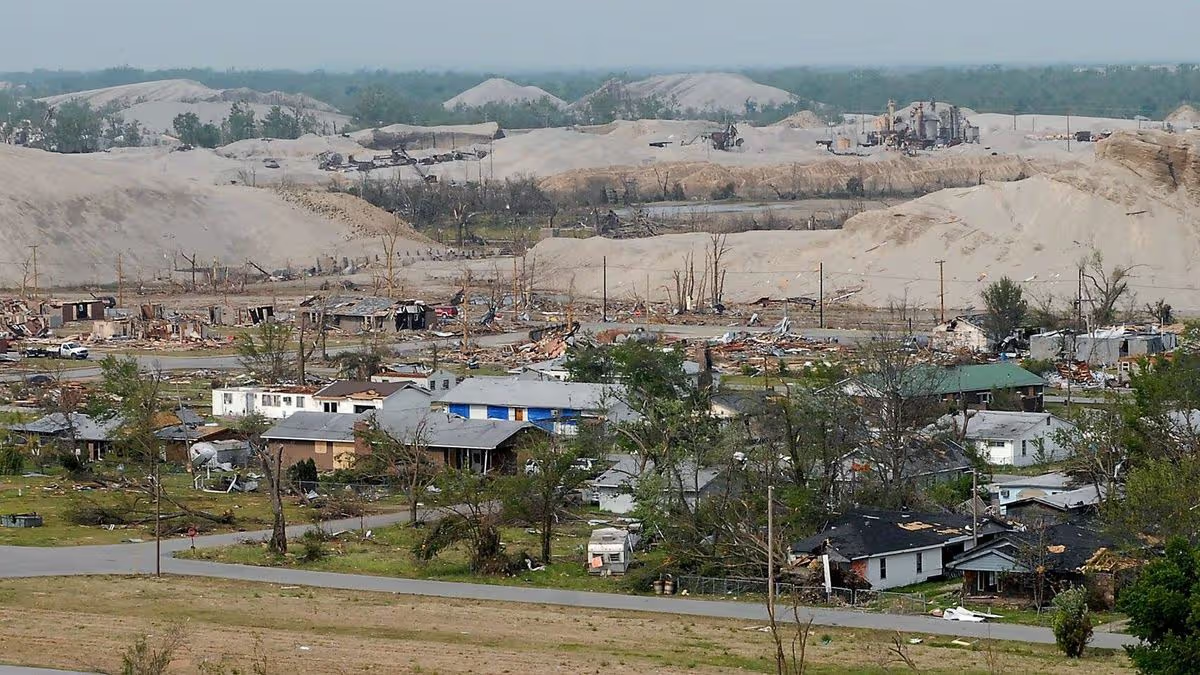
An EF4 tornado entered Picher from the southwest on the evening of May 10, 2008, cut a quarter-mile-wide path through the middle of the town and crossed into Missouri. It killed eight people, injured well over a hundred, and destroyed roughly 150 homes.
The town it hit was already half-empty and mid-demolition, which spared an unknown number of lives and made the aftermath surreal. Emergency crews arrived to search rubble in a municipality that Congress had already voted to dissolve, in neighbourhoods where some of the flattened houses had been standing empty and condemned for months.
Every rebuilding argument had already been settled two years earlier. The tornado did in minutes what the buyout had scheduled across several years, and the practical effect was to collapse every remaining timeline in the town at once.
September 1, 2009: The Day Picher, Oklahoma Stopped Being a Town
Picher-Cardin High School graduated its last class in May 2009. The Gorillas played their final seasons in front of a shrinking town, and the district shut its doors at the end of the school year.
The municipality itself dissolved on September 1, 2009. Water service stopped. The police department stood down. The town of Picher, Oklahoma, ceased to have a legal existence, which is rarer in American history than the frequency of condemnation suggests: Centralia, Pennsylvania went through the same federal buyout process for the same reason a generation earlier and still holds a handful of residents and a legal charter today. Picher was closed outright.
Cardin dissolved the following year. Treece, Kansas, Picher's twin directly across the state line, was bought out and emptied shortly after.
Picher Today: What Remains at America's Most Contaminated Ghost Town
Gary Linderman, the Last Man in Picher, and the Pharmacy That Stayed Open
Gary Linderman kept filling prescriptions after the town stopped existing. He ran the Old Miners Pharmacy on the main street, and when his customers scattered to Miami, Quapaw and half of northeast Oklahoma, he kept the doors open and drove their medicine out to them.
Reporters found him useful, and he gave the same explanation every time: the people who had moved were mostly old, mostly poor, and had been getting their prescriptions from him for thirty years. Somebody had to do it. He worked in a building on a street with almost nothing else left on it, in a town with no municipal government, no water utility and no other business.
Linderman died in June 2015, at 60. The pharmacy closed with him, and the last functioning institution in Picher went with it.
Chat Removal, Remediation Costs and What the Cleanup Has Actually Achieved
The chat is still there. Decades of federal spending — a figure well into the hundreds of millions of dollars — bought yard-by-yard soil replacement, water diversion structures, borehole plugging and the removal of a fraction of the tailings, much of it sold off as aggregate. Tens of millions of tons remain stacked on the ground.
Tar Creek still runs orange in places. Groundwater in the shallow aquifer remains contaminated, and the deeper Roubidoux aquifer, which supplies drinking water to the region, is monitored continuously for the day the shallow water finds a path down into it.
The arithmetic is the entire argument of the site. Mining the Picher field generated enormous wealth, most of it banked far from Ottawa County. Cleaning up after it has cost the public more than any single mining company ever earned here, and the job remains open-ended. The abandoned lead and zinc mine at Faro in the Yukon carries a remediation estimate in the billions of dollars and a water treatment obligation expected to run for centuries.
The Quapaw Nation now holds a direct role in the remediation of ground its own allotments once made profitable, running tribal cleanup operations on land the Bureau of Indian Affairs leased away a century ago.
Visiting Picher, Oklahoma: Access, Safety and the Ethics of a Poisoned Ghost Town
Picher sits just off U.S. 69 in Ottawa County, twenty minutes north of Miami, Oklahoma, and a few miles from the Kansas and Missouri lines. The streets are still on the map and still driveable. Most of what stands is foundation slabs, curbs running into empty lots, a few surviving structures and the chat piles, which dominate the horizon from every direction and are visible on satellite imagery as pale scars across the county.
The site carries real physical risk rather than atmospheric risk. Ground subsidence is the reason the town was closed, and the workings underneath have not been stabilised. Climbing chat piles means inhaling metal-bearing dust, and the flooded pits are acidic. Much of the land is privately held, tribally held, or under active EPA management, and access restrictions are enforced. Photographers and urban explorers have been turned away and cited.
Picher rewards the visitor who stays in the car and looks carefully. The chat piles are the point. They are the accumulated by-product of a century of national demand, sitting where it was left, in the town that was dismantled around it.
The strangest thing about Picher is how ordinary the destruction looks. There is no crater, no burning seam, no exclusion fence around a reactor. There are grass lots where houses were, a grid of empty streets, and grey hills. A town of 14,000 people paid for a war effort with the ground it stood on, and the ground took the town.
Picher, Oklahoma: Frequently Asked Questions
Why was Picher, Oklahoma abandoned?
Picher was abandoned because the ground beneath it became unsafe and the soil above it became toxic. Decades of lead and zinc mining left more than 300 miles of tunnels under the town, and a 2006 U.S. Army Corps of Engineers survey found that the overwhelming majority of its buildings stood over workings at risk of collapse. Separately, mine tailings spread across the town had produced widespread childhood lead poisoning, with roughly one in three local children testing above the federal threshold of concern in 1990s screenings. The federal government concluded that relocating the population was cheaper and safer than remediating the site, and funded a voluntary buyout beginning in 2006. Picher formally dissolved as a municipality on September 1, 2009.
What are the chat piles in Picher, Oklahoma?
Chat piles are mountains of crushed rock left over after lead and zinc were milled out of the ore. Around 75 million tons of this material was stacked in the open across the Picher field, in piles reaching over 200 feet tall, standing directly alongside houses, roads and the town's school. The chat contains lead, cadmium and zinc, and it was widely used across northeast Oklahoma as free construction aggregate for driveways, road base, concrete and even children's sandboxes. Tens of millions of tons remain on the ground today, and they are the dominant feature of the landscape.
Is Picher, Oklahoma safe to visit today?
Picher is drivable but carries genuine physical risk rather than atmospheric risk. Ground subsidence is the reason the town was closed and the underground workings have not been stabilised, so sinkholes remain a live hazard. Climbing the chat piles means inhaling metal-bearing dust, and the flooded pits at their base are acidic. Much of the surrounding land is privately owned, tribally held, or under active EPA management with enforced access restrictions, and photographers and explorers have been turned away and cited.
What happened to the people of Picher, Oklahoma?
Most residents took the buyout and relocated, primarily to nearby Miami, Quapaw and other towns in Ottawa County. Oklahoma began moving families with young children out through a state relocation trust in 2004, and a federal buyout extended the offer to all remaining homeowners and businesses from 2006. A minority refused to leave, and the town spent roughly two years being demolished around the people who stayed. The EF4 tornado of May 10, 2008 killed eight people and destroyed around 150 homes, accelerating the departure of nearly everyone who was left.
Is Tar Creek still contaminated?
Tar Creek remains contaminated and still runs orange in places from iron oxide carried out of the flooded mine workings. Acid mine drainage first reached the surface in 1979, nine years after commercial mining ended, when abandoned tunnels filled with water and pushed metal-laden discharge up through old boreholes. The EPA listed the site on its first National Priorities List in 1983 and has spent decades on soil replacement, borehole plugging and water diversion. The shallow aquifer remains contaminated, and the deeper Roubidoux aquifer that supplies regional drinking water is monitored continuously.
Who was the last person living in Picher, Oklahoma?
Gary Linderman, a pharmacist, is generally described as the last man in Picher. He ran the Old Miners Pharmacy on the main street and kept it open after the town legally ceased to exist, driving prescriptions out to former customers who had scattered across the county. He explained his decision the same way each time reporters asked: his customers were mostly elderly, mostly poor, and had relied on him for thirty years. Linderman died in June 2015 at the age of 60, and the pharmacy closed with him.
Sources
Tar Creek (Ottawa County) Superfund Site: Records of Decision and Five-Year Review Reports — U.S. Environmental Protection Agency, Region 6
Tar Creek Subsidence Evaluation, Picher, Cardin and Hockerville, Oklahoma — U.S. Army Corps of Engineers, Tulsa District (2006)
Public Health Assessment, Tar Creek Superfund Site, Ottawa County, Oklahoma — Agency for Toxic Substances and Disease Registry
Lead and Zinc Resources of the Tri-State Mining District — U.S. Geological Survey
Picher — Encyclopedia of Oklahoma History and Culture, Oklahoma Historical Society
Governor's Tar Creek Task Force Final Report — State of Oklahoma (2000)
Mining and Mineral Resources of the Picher Field — Oklahoma Geological Survey
Tar Creek Superfund Site Cleanup Program — Quapaw Nation Environmental Office
The Last Boy: Mickey Mantle and the End of America's Childhood — Jane Leavy (2010)
Public Health Statement for Lead — Agency for Toxic Substances and Disease Registry
May 10, 2008 Tornado Outbreak Event Summary — National Weather Service, Tulsa Forecast Office
Tar Creek — Matt Myers, documentary film (2009)